
The Northern Territory is an Australian internal territory in the central and central-northern regions of Australia. The Northern Territory shares its borders with Western Australia to the west, South Australia to the south, and Queensland to the east. To the north, the Northern Territory looks out to the Timor Sea, the Arafura Sea and the Gulf of Carpentaria, including Western New Guinea and various other islands of the Indonesian archipelago.

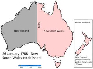
New South Wales is a state on the east coast of Australia. It borders Queensland to the north, Victoria to the south, and South Australia to the west. Its coast borders the Coral and Tasman Seas to the east. The Australian Capital Territory and Jervis Bay Territory are enclaves within the state. New South Wales' state capital is Sydney, which is also Australia's most populous city. In December 2023, the population of New South Wales was over 8.3 million, making it Australia's most populous state. Almost two-thirds of the state's population, 5.3 million, live in the Greater Sydney area.

The Jervis Bay Territory is an internal territory of Australia. It was established in 1915, from a part of New South Wales (NSW), in order to give the landlocked Australian Capital Territory (ACT) access to the sea.

Port Jackson, consisting of the waters of Sydney Harbour, Middle Harbour, North Harbour and the Lane Cove and Parramatta Rivers, is the ria or natural harbour of Sydney, New South Wales, Australia. The harbour is an inlet of the Tasman Sea. It is the location of the Sydney Opera House and Sydney Harbour Bridge. The location of the first European settlement and colony on the Australian mainland, Port Jackson has continued to play a key role in the history and development of Sydney.

Darwin Harbour is a body of water close to the city of Darwin in the Northern Territory of Australia. It is the traditional waterways of the Larrakia people.

Princes Highway is a major road in Australia, extending from Sydney via Melbourne to Adelaide through the states of New South Wales, Victoria and South Australia. It has a length of 1,941 kilometres (1,206 mi) or 1,898 kilometres (1,179 mi) via the former alignments of the highway, although these routes are slower and connections to the bypassed sections of the original route are poor in many cases.

Pacific Highway is a 790-kilometre-long (491 mi) national highway and major transport route along the central east coast of Australia, with the majority of the highway being part of Australia's Highway 1. The highway and its adjoining Pacific Motorway between Brisbane and Brunswick Heads and Pacific Motorway between Sydney and Newcastle links the state capitals of Sydney in New South Wales with Brisbane in Queensland. It approximately parallels the Tasman Sea and the Coral Sea of the South Pacific Ocean coast. Additionally, between Brunswick Heads and Port Macquarie, the road is also signed as Pacific Motorway, but has not been legally gazetted as such.

Kings Highway is an interstate highway located within the Australian Capital Territory and New South Wales, Australia. The highway connects Canberra with Batemans Bay on the South Coast. It is designated route B52.
Since the 19th century, there have been proposals for the creation or incorporation of new states of Australia. Chapter VI of the Constitution of Australia provides for the admission of new states to the federation. Proposals have included admitting territories to statehood, admitting independent countries, and forming new states from parts of existing states. However, no new states have been added since the federation of six former British self-governing colonies in 1901, as states of the new Commonwealth of Australia.
John Clements Wickham was a Scottish explorer, naval officer, magistrate and administrator. He was first lieutenant on HMS Beagle during its second survey mission, 1831–1836, under captain Robert FitzRoy. The young naturalist and geologist Charles Darwin was a supernumerary on the ship, and his journal was published as The Voyage of the Beagle. After that expedition, Wickham was promoted to Commander and made captain of the Beagle on its third voyage, from 1837 and conducted various maritime expeditions and hydrographic surveys along the Australian coastline.

Bradfield Highway is a 2.1-kilometre (1.3 mi) highway that crosses the Sydney Harbour Bridge in Sydney, New South Wales and is one of the shortest highways in Australia. It opened along with the bridge itself on 19 March 1932 and was named in honour of John Bradfield, the engineer who designed and helped construct it.

Cahill Expressway is an urban freeway in Sydney and was the first freeway constructed in Australia, with the first section, from the Bradfield Highway to Conservatorium Place being opened to traffic in March 1958. It links the southern end of the Sydney Harbour Bridge, via an elevated roadway, a tunnel and cuttings between the Royal Botanic Garden and The Domain, to Woolloomooloo in Sydney's inner-eastern suburbs.
Central Coast Highway is a 50-kilometre (31 mi) highway through the Central Coast region of New South Wales, Australia. It connects Pacific Motorway (M1) at Kariong with Pacific Highway (A43) at Doyalson. The highway was named after the region it goes through, to provide an easily identifiable route for visitors to the region, and is designated route A49.

An extensive multi-modal transport system serves the state of New South Wales, Australia. The lead government agency responsible for the network's operation and development is Transport for NSW.
Suburbs and localities are the names of geographic subdivisions in Australia, used mainly for address purposes. The term locality is used in rural areas, while the term suburb is used in urban areas. Australian postcodes closely align with the boundaries of localities and suburbs.

The Man O'War Steps is a heritage-listed jetty located at Farm Cove Crescent, in the Sydney central business district, in the City of Sydney local government area of New South Wales, Australia. It was built from 1810. The property is owned by Transport for NSW. It was added to the New South Wales State Heritage Register on 18 April 2000. The Steps are located on the eastern bank of Bennelong Point, adjacent to the Sydney Opera House and on the north-western boundary of the Royal Botanic Garden.