Port Douglas

Last updated

Port Douglas
Queensland
Port douglas qld australia.jpg
Four Mile Beach
Australia Queensland location map.svg
Red pog.svg
Port Douglas
Coordinates 16°29′00″S145°27′55″E / 16.4834°S 145.4652°E / -16.4834; 145.4652
Population3,650 (2021 census) [1]
 • Density202.8/km2 (525.2/sq mi)
Postcode(s) 4877
Elevation4 m (13 ft)
Area18.0 km2 (6.9 sq mi)
Time zone AEST (UTC+10:00)
Location
LGA(s) Shire of Douglas
County Solander
State electorate(s) Cook
Federal division(s) Leichhardt
Mean max tempMean min tempAnnual rainfall
27.9 °C
82 °F
20.6 °C
69 °F
2,032.4 mm
80 in
Localities around Port Douglas:
Killaloe Coral Sea Coral Sea
Killaloe Port Douglas Coral Sea
Craiglie Craiglie Craiglie

Port Douglas is a coastal town and locality in the Shire of Douglas, Queensland, Australia, [2] [3] approximately 60 km north of Cairns.

Contents

In the 2021 census, the locality of Port Douglas had a population of 3,650 people. [1] The town's population can often double, however, with the influx of tourists during the peak tourism season from May to September.

The town is named in honour of a former Premier of Queensland, John Douglas. Port Douglas developed quickly based on the mining industry. Other parts of the area were established with timber cutting in the area surrounding the Daintree River and with settlement starting on lots around the Mossman River by 1880.

Previous names for the town included Terrigal, Island Point, Port Owen and Salisbury. The town is situated adjacent to two World Heritage areas, the Great Barrier Reef and the Daintree Rainforest.

Port Douglas was No. 3 on Australian Traveller magazine's list of 100 Best Towns in Australia. [4]

History

Port Douglas War Memorial, 2020 Port Douglas War Memorial, Queensland, 2020, 01.jpg
Port Douglas War Memorial, 2020

The Port Douglas township was established in 1877 after the discovery of gold at Hodgkinson River by James Venture Mulligan. Port Douglas Post Office opened on 1 September 1877. [5] It grew quickly, and at its peak Port Douglas had a population of 12,000 and 27 hotels. With the construction of the Mulligan Highway it serviced towns as far away as Herberton.

Port Douglas State School opened on 11 November 1879, but closed in 1962. It was reopened on 23 January 1989. [6] [7]

When the Kuranda Railway from Cairns to Kuranda was completed in 1891, the importance of Port Douglas dwindled along with its population. A cyclone in 1911 demolished or severely damaged all but seven residential buildings and 4 commercial buildings, including the Wharf buildings (rebuilt), the Courthouse (rebuilt), the Catholic church (rebuilt) and Chinese temple (not rebuilt). [8] [9]

The Port Douglas War Memorial was unveiled on 10 February 1923 by Mrs Tresize. [10]

On 5 July 1943, a RAAF Vultee Vengeance (Serial Number A27-217) crash landed on the beach near Port Douglas. [11]

At its nadir in 1960 the town, by then little more than a fishing village, had a population of 100.[ citation needed ]

In the late-1980s, tourism boomed in the region after investor Christopher Skase financed the construction of the Sheraton Mirage Port Douglas Resort.

The music video for Kylie Minogue's 1988 single "It's No Secret" was filmed in Port Douglas.[ citation needed ]

In November 1996 United States President Bill Clinton and First Lady Hillary Clinton chose the town as their only holiday stop on their historic visit to Australia. When dining at a local restaurant they witnessed a couple's wedding certificate. [12]

On a return visit on 11 September 2001, Bill Clinton was again dining at a local restaurant, when he was advised of the September 11 attacks. He returned to the United States the following day. [12]

On 4 September 2006, television personality and conservationist Steve Irwin died at Batt Reef, off Port Douglas, after a stingray barb pierced his chest during filming of a documentary called The Ocean's Deadliest. [13] Irwin was filmed snorkelling directly above the stingray when it lashed him with its tail, killing him almost immediately. The event was widely reported in Australia and overseas. [14]

Although historically and currently Port Douglas is with the local government area of Shire of Douglas, between 2008 and 2013, it was within the Cairns Region following a local government amalgamation which was subsequently reversed following a vote by residents of the area. [15]

Port Douglas was a popular location to view the 14 November 2012 solar eclipse at 6:38 am (local time). Thousands travelled to Port Douglas to see the phenomenon.[ citation needed ] [16]

Demographics

At the 2011 census, the locality of Port Douglas had a population of 3,205 people. [17]

In the 2016 census, the locality of Port Douglas had a population of 3,504 people. [18]

In the 2021 census, the locality of Port Douglas had a population of 3,650 people. [1]

Heritage listings

St Mary's by the Sea (former Catholic church, 1914-1988) St Mary's by the Sea, Port Douglas, 2020, 02.jpg
St Mary's by the Sea (former Catholic church, 1914–1988)

Port Douglas has a number of heritage-listed sites, including:

Demographics

In the 2016 census, the locality of Port Douglas had a population of 3,504 people. [18]

In the 2021 census, the locality of Port Douglas had a population of 3,650 people. 51.9% of people were born in Australia. The next most common countries of birth were England 6.7% and New Zealand 4.1%. 69.9% of people spoke only English at home. The most common responses for religion were No Religion, so described 46.7% and not stated 16.3%. [1]

Climate

Port Douglas has a tropical monsoon climate according to the Köppen climate classification (Am), with hot summers and warm winters, with heavy rainfall primarily from January–March, the wettest month of the year typically being February. The average temperature of the sea ranges from 23.7 °C (74.7 °F) in July to 29.5 °C (85.1 °F) in January. [23]

Climate data for Port Douglas, Queensland
MonthJanFebMarAprMayJunJulAugSepOctNovDecYear
Mean daily maximum °C (°F)30.3
(86.5)
30.1
(86.2)
29.5
(85.1)
28.3
(82.9)
26.7
(80.1)
25.1
(77.2)
24.6
(76.3)
25.3
(77.5)
26.7
(80.1)
28.3
(82.9)
29.5
(85.1)
30.3
(86.5)
27.9
(82.2)
Mean daily minimum °C (°F)23.7
(74.7)
23.5
(74.3)
22.8
(73.0)
21.5
(70.7)
19.5
(67.1)
17.7
(63.9)
16.8
(62.2)
17.1
(62.8)
18.6
(65.5)
20.8
(69.4)
22.3
(72.1)
23.3
(73.9)
20.6
(69.1)
Average precipitation mm (inches)401.6
(15.81)
429.7
(16.92)
425.6
(16.76)
204.8
(8.06)
70.8
(2.79)
47.3
(1.86)
25.6
(1.01)
24.1
(0.95)
32.0
(1.26)
52.0
(2.05)
107.9
(4.25)
213.2
(8.39)
2,032.4
(80.02)
Average precipitation days15.515.916.113.39.87.05.55.25.46.49.011.7120.8
Source: Bureau of Meteorology [24]

Environmental challenges

Port Douglas is susceptible to extreme weather events such as cyclones and floods. These events can have immediate and severe impacts on critical infrastructure, including water supply systems. In the end of 2023, they experienced a critical water supply issues following a cyclone. [25]

Education

Port Douglas State School is a government primary (Preparatory to Year 6) school for boys and girls at Endeavour Street ( 16°31′27″S145°27′40″E / 16.5242°S 145.4612°E / -16.5242; 145.4612 (Port Douglas State School) ). [26] [27] In 2017, the school had an enrolment of 281 students with 20 teachers (17 full-time equivalent) and 12 non-teaching staff (8 full-time equivalent). [28]

For secondary school, Port Douglas is within the catchment of Mossman State High School. [29]

Amenities

The Port Douglas Community Hall houses the Port Douglas Library, 11–29 Mowbray Street, operated by the Douglas Shire Council. [30] The Library opened in 2010. [31] Another branch library is located in Mossman. [32]

The Port Douglas branch of the Queensland Country Women's Association meets at the CWA Hall at 8 Blake Street. [33]

St Mary's Catholic Church is at 2 Endeavour Street. It is within the Mossman-Port Douglas Parish of the Roman Catholic Diocese of Cairns. [34]

Events

Beach in Port Douglas Four Mile Beach, Port Douglas, Queensland, 2020 04.jpg
Beach in Port Douglas

The annual Port Douglas Carnivale is held in May and runs for 10 days over two weekends, beginning with a parade attracting over 10,000 people. [35]

In October Porttoberfest (a play on Oktoberfest ) is held.[ citation needed ]

The Great Barrier Reef Marathon Festival is also held during October. [36]

Every May The Port Douglas Yacht Club hold their annual Regatta in May. Port Douglas Race Week attracts yachts from all along the Eastern Seaboard and provide views for visitors from Four Mile Beach.[ citation needed ]

Attractions

Kitesurfing at Port Douglas, Australia Kitesurfing Port Douglas.jpg
Kitesurfing at Port Douglas, Australia

Kitesurfing is common at the southern end of Four Mile Beach, particularly during the winter months when trade winds blow from the South.[ citation needed ]

Port Douglas is near the Great Barrier Reef. Numerous companies run daily trips from the marina to the outer reef and the Low Isles for scuba diving and snorkelling. Port Douglas is also well known for its many restaurants, walks, golf courses, and five star resorts.

Near the centre of town is a wildlife park that displays crocodiles, tree-kangaroos, cassowaries, koalas, quolls, flying foxes and other native animals.

Related Research Articles

<span class="mw-page-title-main">Daintree National Park</span> Protected area in Queensland, Australia

The Daintree National Park is located in Far North Queensland, Australia, 1,757 km (1,092 mi) northwest of Brisbane and 100 km (62 mi) northwest of Cairns. It was founded in 1981 and is part of the Wet Tropics of Queensland. In 1988, it became a World Heritage Site. The park consists of two sections—Mossman Gorge and Cape Tribulation, with a settled agricultural area between them which includes the towns of Mossman and Daintree Village.

<span class="mw-page-title-main">Cairns</span> City in Queensland, Australia

Cairns is a city in the Cairns Region, Queensland, Australia, on the tropical north east coast of Far North Queensland. In the 2021 census, Cairns had a population of 153,181 people.

<span class="mw-page-title-main">Daintree, Queensland</span> Town in Queensland, Australia

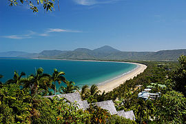
Daintree is a rural town and locality in the Shire of Douglas, Queensland, Australia. In the 2021 census, the locality of Daintree had a population of 93 people.

<span class="mw-page-title-main">Cape Tribulation, Queensland</span> Suburb of Shire of Douglas, Queensland, Australia

Cape Tribulation is a headland and coastal locality in the Shire of Douglas in northern Queensland, Australia. In the 2021 census, Cape Tribulation had a population of 123 people.

<span class="mw-page-title-main">Far North Queensland</span> Region in Queensland, Australia

Far North Queensland (FNQ) is the northernmost part of the Australian state of Queensland. Its largest city is Cairns and it is dominated geographically by Cape York Peninsula, which stretches north to the Torres Strait, and west to the Gulf Country. The waters of Torres Strait include the only international border in the area contiguous with the Australian mainland, between Australia and Papua New Guinea.

<span class="mw-page-title-main">Mossman, Queensland</span> Town in Queensland, Australia

Mossman is a rural town and locality in the Shire of Douglas, Queensland, Australia. It is the administrative centre for the Douglas Shire Council In the 2021 census, the locality of Mossman had a population of 1,935 people.

<span class="mw-page-title-main">Shire of Douglas</span> Local government area in Queensland, Australia

The Shire of Douglas is a local government area in Far North Queensland. It is located on the coast north of the city of Cairns. The shire, administered from the town of Mossman, covers an area of 2,428 square kilometres (937.5 sq mi), and existed as a local government entity from 1880 until 2008, when it was amalgamated with the City of Cairns to become the Cairns Region. Following a poll in 2013, the Shire of Douglas was re-established on 1 January 2014.

<span class="mw-page-title-main">Shire of Cook</span> Local government area in Queensland, Australia

The Shire of Cook is a local government area in Far North Queensland, Australia. The Shire covers most of the eastern and central parts of Cape York Peninsula, the most northerly section of the Australian mainland.

<span class="mw-page-title-main">Wonga Beach, Queensland</span> Suburb of Shire of Douglas, Queensland, Australia

Wonga Beach is a coastal locality in the Shire of Douglas, Queensland, Australia. The town of Wonga is within the locality. In the 2021 census, Wonga Beach had a population of 1,042 people.

<span class="mw-page-title-main">Wujal Wujal Aboriginal Shire</span> Local government area in Queensland, Australia

The Wujal Wujal Aboriginal Shire is a local government area in Far North Queensland, Australia. It is managed as a Deed of Grant in Trust under the Local Government Act 2004.

<span class="mw-page-title-main">Bloomfield, Queensland</span> Town in Queensland, Australia

Bloomfield is a rural town in the Shire of Cook and a coastal locality which is split between the Shire of Cook and the Shire of Douglas in Queensland, Australia. The neighbourhood of Ayton is within the locality. In the 2021 census, the locality of Bloomfield had a population of 228 people.

<span class="mw-page-title-main">Palmer, Queensland</span> Suburb of Shire of Cook, Queensland, Australia

Palmer is a rural locality in the Shire of Cook, Queensland, Australia. In the 2021 census, Palmer had a population of 46 people.

<span class="mw-page-title-main">Miallo, Queensland</span> Suburb of Shire of Douglas, Queensland, Australia

Miallo is a rural locality in the Shire of Douglas, Queensland, Australia. In the 2021 census, Miallo had a population of 406 people.

<span class="mw-page-title-main">Mowbray, Queensland</span> Suburb of Shire of Douglas, Queensland, Australia

Mowbray is a coastal locality in the Shire of Douglas, Queensland, Australia. In the 2021 census, Mowbray had a population of 362 people.

<span class="mw-page-title-main">Whyanbeel</span> Suburb of Shire of Douglas, Queensland, Australia

Whyanbeel is a rural locality in the Shire of Douglas, Queensland, Australia. In the 2021 census, Whyanbeel had a population of 172 people.

<span class="mw-page-title-main">Newell, Queensland</span> Town in Queensland, Australia

Newell is a coastal town and rural locality in the Shire of Douglas, Queensland, Australia. It is a sugarcane growing district.

<span class="mw-page-title-main">Lower Daintree, Queensland</span> Suburb of Shire of Douglas, Queensland, Australia

Lower Daintree is a coastal rural locality in the Shire of Douglas, Queensland, Australia. In the 2021 census, Lower Daintree had a population of 83 people.

<span class="mw-page-title-main">Forest Creek, Queensland</span> Suburb of Shire of Douglas, Queensland, Australia

Forest Creek is a locality in the Shire of Douglas, Queensland, Australia. In the 2021 census, Forest Creek had a population of 136 people.

<span class="mw-page-title-main">Thornton Beach, Queensland</span> Town in Queensland, Australia

Thornton Beach is a coastal town and locality in the Shire of Douglas, Queensland, Australia. In the 2021 census, the locality of Thornton Beach had a population of 8 people.

<span class="mw-page-title-main">Low Isles, Queensland</span> Suburb of Shire of Douglas, Queensland, Australia

Low Isles is an offshore locality in the Shire of Douglas, Queensland, Australia. Located in the Coral Sea, the islands are due east of Rocky Point and approximately 14.5 kilometres (9.0 mi) north-east of Port Douglas on the Queensland mainland coast. In the 2021 census, Low Isles had "no people or a very low population".

References

  1. 1 2 3 4 Australian Bureau of Statistics (28 June 2022). "Port Douglas (Suburbs and Localities)". 2021 Census QuickStats. Retrieved 20 December 2023. OOjs UI icon edit-ltr-progressive.svg
  2. "Port Douglas – town in Shire of Douglas (entry 27348)". Queensland Place Names. Queensland Government . Retrieved 26 November 2018.
  3. "Port Douglas – locality in Shire of Douglas (entry 48847)". Queensland Place Names. Queensland Government . Retrieved 26 November 2018.
  4. "100 Best Towns in Australia". "100 Best Towns in Australia | Australian Traveller". Archived from the original on 17 July 2013. Retrieved 21 July 2013. Retrieved 21 July 2013
  5. Phoenix Auctions History. "Post Office List". Phoenix Auctions. Retrieved 23 January 2021.
  6. "Opening and closing dates of Queensland Schools". Queensland Government . Retrieved 18 April 2019.
  7. Queensland Family History Society (2010), Queensland schools past and present (Version 1.01 ed.), Queensland Family History Society, ISBN   978-1-921171-26-0
  8. "A DEVASTATING CALAMITY". The Brisbane Courier. No. 16, 597. Queensland, Australia. 22 March 1911. p. 5. Retrieved 14 April 2017 via National Library of Australia.
  9. "The Port Douglas Disaster". Cairns Post . Vol. XXV, no. 975. Queensland, Australia. 24 March 1911. p. 2. Retrieved 14 December 2023 via National Library of Australia.
  10. "Port Douglas War Memorial". Monument Australia. Archived from the original on 7 April 2014. Retrieved 4 April 2014.
  11. "5 July 1943: Crash of a Vultee Vengeance on a beach near Port Douglas, Qld". Australia @ War. 29 October 2018. Archived from the original on 28 September 2017. Retrieved 26 November 2018.
  12. 1 2 KING, LARRY (3 September 2002). "Interview With Bill Clinton, Bob Dole, Andrew McKelvey, Dan Rather". CNN. Archived from the original on 22 May 2011. Retrieved 15 November 2010.
  13. Jason Staines Crocodile man, Steve Irwin, dies Archived 19 October 2012 at the Wayback Machine , The Age , 4 September 2006
  14. Death footage 'will never see the light of day' Archived 8 April 2016 at the Wayback Machine , The Age, 7 September 2006
  15. "De-Amalgamation Information". Douglas Shire Council. Archived from the original on 20 November 2020. Retrieved 20 November 2020.
  16. Family, Author Alyson for World Travel (14 November 2012). "Total Solar Eclipse Port Douglas, In Photos | World Travel Family" . Retrieved 14 March 2021.{{cite web}}: |first= has generic name (help)
  17. Australian Bureau of Statistics (31 October 2012). "Port Douglas". 2011 Census QuickStats. Retrieved 27 January 2014. OOjs UI icon edit-ltr-progressive.svg
  18. 1 2 Australian Bureau of Statistics (27 June 2017). "Port Douglas (SSC)". 2016 Census QuickStats. Retrieved 20 October 2018. OOjs UI icon edit-ltr-progressive.svg
  19. "FDA Carstens Memorial (entry 601053)". Queensland Heritage Register . Queensland Heritage Council. Retrieved 7 July 2013.
  20. "St Mary's by the Sea (entry 600464)". Queensland Heritage Register . Queensland Heritage Council. Retrieved 7 July 2013.
  21. "Port Douglas Wharf and Storage Shed (former) (entry 600466)". Queensland Heritage Register . Queensland Heritage Council. Retrieved 7 July 2013.
  22. "Port Douglas Court House Museum (entry 600465)". Queensland Heritage Register . Queensland Heritage Council. Retrieved 7 July 2013.
  23. "Port Douglas Water Temperature | Australia Sea Temperatures". Archived from the original on 15 May 2018. Retrieved 7 June 2017.
  24. "Climate Statistics for Port Douglas, Queensland". 17 February 2012. Archived from the original on 27 February 2012.
  25. "Queensland town's water supply at 'critical low'". www.9news.com.au. 29 December 2023. Retrieved 30 January 2024.
  26. "State and non-state school details". Queensland Government. 9 July 2018. Archived from the original on 21 November 2018. Retrieved 21 November 2018.
  27. "Port Douglas State School". Archived from the original on 21 April 2013. Retrieved 21 November 2018.
  28. "ACARA School Profile 2017". Archived from the original on 22 November 2018. Retrieved 22 November 2018.
  29. "Queensland Globe". State of Queensland . Retrieved 26 November 2018.
  30. "Port Douglas, Directory of Public Libraries". Public Libraries Connect. 30 October 2017. Archived from the original on 1 February 2018. Retrieved 1 February 2018.
  31. "Queensland Public Libraries Statistical Bulletin 2016–2017" (PDF). Public Libraries Connect. November 2017. Archived (PDF) from the original on 30 January 2018. Retrieved 1 February 2018.
  32. "Douglas Shire, Public Libraries Connect". Public Libraries Connect. 20 September 2016. Archived from the original on 1 February 2018. Retrieved 1 February 2018.
  33. "Branch Locations". Queensland Country Women's Association. Archived from the original on 26 December 2018. Retrieved 26 December 2018.
  34. "Mossman-Port Douglas Parish". Roman Catholic Diocese of Cairns . Archived from the original on 18 November 2020. Retrieved 18 November 2020.
  35. Cotton, Martine. "Port Douglas Carnivale". Port Douglas Chamber of Commerce. Archived from the original on 20 February 2010. Retrieved 15 November 2010.
  36. Cullen, Sam. "Great Barrier Reef Marathon Festival". Port Douglas Event Management. Archived from the original on 5 July 2017. Retrieved 11 June 2017.