Aboriginal Shire of Yarrabah

Last updated

Aboriginal Shire of Yarrabah
Queensland
Yarrabah LGA Qld.png
Location within Queensland
Population2,505 (2021 census) [1]
 • Density15.75/km2 (40.80/sq mi)
Established1987
Area159 km2 (61.4 sq mi) [2]
MayorRoss Andrews
Council seat Yarrabah
Region Far North
State electorate(s) Mulgrave
Federal division(s) Kennedy
Yarrabah Aboriginal Shire Council.jpg
Website Aboriginal Shire of Yarrabah
LGAs around Aboriginal Shire of Yarrabah:
Cairns Coral Sea Coral Sea
Cairns Aboriginal Shire of Yarrabah Coral Sea
Cairns Cairns Cairns

The Aboriginal Shire of Yarrabah is a special local government area in Far North Queensland, Queensland, Australia, east and southeast of Cairns on Cape Grafton. It is managed under a Deed of Grant in Trust under the Local Government (Community Government Areas) Act 2004.

Contents

In the 2021 census, the Aboriginal Shire of Yarrabah had a population of 2,505 people. [1]

History

The area originally was set up as an Anglican Mission in 1892. Aboriginal people from the region were gradually drawn or relocated from their traditional lands into the mission settlement. The Gungganydji people were the main group to be settled there.

In the 1960s, the Anglican Church relinquished control of the mission. The Department of Aboriginal and Islander Affairs, a government department, under the Act continued running the affairs of the community.

On 29 October 1987, under the Community Services (Aborigines) Act 1984, a Deed of Grant in Trust was given to the Yarrabah community over the Cape Grafton area. Like other DOGIT communities of the time, Yarrabah had a Community Council elected by Aboriginal people living in the community.

Demographics

In the 2016 census, the Aboriginal Shire of Yarrabah had a population of 2,559 people. [3]

In the 2021 census, the Aboriginal Shire of Yarrabah had a population of 2,505 people. [1]

Responsibilities

As the Shire is not operated under the Local Government Act and operates the land on behalf of the community, the Shire Council's responsibilities are quite different from a typical local government body. This includes responsibility for fisheries, alcohol management and employment initiatives.

The Yarrabah Aboriginal Shire Council operates an Indigenous Knowledge Centre at Noble Drive in Yarrabah. [4] [5]

Mayors

See also

Related Research Articles

<span class="mw-page-title-main">Shire of Paroo</span> Local government area in Queensland, Australia

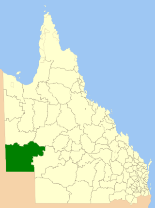
The Shire of Paroo is a local government area in South West Queensland, Australia. The administrative centre is the town of Cunnamulla. The Paroo Shire covers an area of 47,623 square kilometres (18,387 sq mi). In the 2021 census, the Shire of Paroo had a population of 1,679 people.

<span class="mw-page-title-main">Yarrabah, Queensland</span> Town in Queensland, Australia

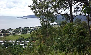
Yarrabah is a coastal town and locality in the Aboriginal Shire of Yarrabah, Queensland, Australia. It is an Aboriginal community. In the 2021 census, the locality of Yarrabah had a population of 2,505 people.

<span class="mw-page-title-main">Shire of Diamantina</span> Local government area in Queensland, Australia

The Shire of Diamantina is a local government area in Central West Queensland, bordering South Australia and the Northern Territory. Its administrative centre is in the town of Bedourie.

<span class="mw-page-title-main">Shire of McKinlay</span> Local government area in Queensland, Australia

The Shire of McKinlay is a local government area in outback north-western Queensland, Australia.

<span class="mw-page-title-main">Shire of Etheridge</span> Local government area in Queensland, Australia

The Shire of Etheridge is a local government area in Far North Queensland, Australia in what is known as the Savannah Gulf region. Its economy is based on cattle grazing and mining.

<span class="mw-page-title-main">Shire of Croydon</span> Local government area in Queensland, Australia

The Shire of Croydon is a local government area in western Queensland, Australia. The shire, administered from the town of Croydon, covers an area of 29,498 square kilometres (11,389.2 sq mi). The council consists of a mayor plus four councillors, each of whom represents the entire Shire.

<span class="mw-page-title-main">Shire of Cook</span> Local government area in Queensland, Australia

The Shire of Cook is a local government area in Far North Queensland, Australia. The Shire covers most of the eastern and central parts of Cape York Peninsula, the most northerly section of the Australian mainland.

<span class="mw-page-title-main">Shire of Torres</span> Local government area in Queensland, Australia

The Shire of Torres is a local government area located in Far North Queensland, Australia, covering large sections of the Torres Strait Islands and the northern tip of Cape York Peninsula north of 11°S latitude. It holds two distinctions—it is the northernmost Local Government Area in Australia, and is the only one to abut an international border – it is at one point just 73 kilometres (45 mi) from Papua New Guinea. It is administered from Thursday Island.

<span class="mw-page-title-main">Shire of Mornington (Queensland)</span> Local government area in Queensland, Australia

The Shire of Mornington is a local government area in northwestern Queensland, Australia. The shire covers the Wellesley Islands, which includes Mornington Island; the South Wellesley Islands; Bountiful Islands; and West Wellesley / Forsyth Islands groups in the Gulf of Carpentaria.

<span class="mw-page-title-main">Aboriginal Shire of Doomadgee</span> Local government area in Queensland, Australia

The Aboriginal Shire of Doomadgee is a special local government area in North West Queensland, Queensland, Australia. It is managed under a Deed of Grant in Trust under the Local Government Act 2004.

<span class="mw-page-title-main">Maranoa Region</span> Local government area in Queensland, Australia

Maranoa Region is a local government area in South West Queensland, Australia. The town of Roma is the administrative headquarters of the region.

<span class="mw-page-title-main">Isaac Region</span> Local government area in Queensland, Australia

The Isaac Region is a local government area located in Central Queensland, Queensland, Australia created in March 2008 as a result of the report of the Local Government Reform Commission released in July 2007.

<span class="mw-page-title-main">Central Highlands Region</span> Local government area in Queensland, Australia

Central Highlands Region is a local government area in Queensland, Australia. In the 2021 census, the Central Highlands Region had a population of 27,836 people.

<span class="mw-page-title-main">Cassowary Coast Region</span> Local government area in Queensland, Australia

The Cassowary Coast Region is a local government area in the Far North Queensland region of Queensland, Australia, south of Cairns and centred on the towns of Innisfail, Cardwell and Tully. It was created in 2008 from a merger of the Shire of Cardwell and the Shire of Johnstone.

<span class="mw-page-title-main">Tablelands Region</span> Local government area in Queensland, Australia

The Tablelands Region is a local government area in Far North Queensland, Australia inland from the city of Cairns. Established in 2008, it was preceded by four previous local government areas which dated back more than a century. On 1 January 2014, one of those local government areas, the Shire of Mareeba, was re-established independent of the Tablelands Region.

<span class="mw-page-title-main">Blackall-Tambo Region</span> Local government area in Queensland, Australia

The Blackall-Tambo Region is a local government area in Central West Queensland, Australia. Established in 2008, it was preceded by two previous local government areas dating from the 1870s.

<span class="mw-page-title-main">Charters Towers Region</span> Local government area in Queensland, Australia

The Charters Towers Region is a local government area in North Queensland, Australia southwest of, and inland from the city of Townsville, based in Charters Towers. Established in 2008, it was preceded by two previous local government areas which dated back to the 1870s.

<span class="mw-page-title-main">Aboriginal Shire of Kowanyama</span> Local government area in Queensland, Australia

The Aboriginal Shire of Kowanyama is a special local government area which is located on western Cape York Peninsula in Queensland, Australia. It is managed under a Deed of Grant in Trust under the Local Government Act 2004.

<span class="mw-page-title-main">Aboriginal Shire of Pormpuraaw</span> Local government area in Queensland, Australia

The Aboriginal Shire of Pormpuraaw is a special local government area which is located on western Cape York Peninsula in Queensland, Australia. It is managed under a Deed of Grant in Trust under the Local Government Act 2004.

<span class="mw-page-title-main">Aboriginal Shire of Hope Vale</span> Local government area in Queensland, Australia

The Aboriginal Shire of Hope Vale is a local government area in Far North Queensland, Queensland, Australia, north of the town of Cooktown. The majority of the Shire consists of Deed of Grant land that is held for the benefit of Aboriginal people particularly concerned with the land and their ancestors and descendants.

References

  1. 1 2 3 Australian Bureau of Statistics (28 June 2022). "Aboriginal Shire of Yarrabah (LGA)". 2021 Census QuickStats. Retrieved 28 February 2023. OOjs UI icon edit-ltr-progressive.svg
  2. "3218.0 – Regional Population Growth, Australia, 2017-18: Population Estimates by Local Government Area (ASGS 2018), 2017 to 2018". Australian Bureau of Statistics. Australian Bureau of Statistics. 27 March 2019. Retrieved 25 October 2019. Estimated resident population, 30 June 2018.
  3. Australian Bureau of Statistics (27 June 2017). "Aboriginal Shire of Yarrabah (LGA)". 2016 Census QuickStats. Retrieved 20 October 2018. OOjs UI icon edit-ltr-progressive.svg
  4. "Yarrabah Knowledge Centre". State Library of Queensland. Archived from the original on 7 March 2016. Retrieved 24 January 2018.
  5. "Yarrabah Knowledge Centre". Public Libraries Connect. State Library of Queensland . Retrieved 9 January 2017.
  6. "2008 Yarrabah Aboriginal Shire Council - Mayoral Election - Election Summary". results.ecq.qld.gov.au. Retrieved 4 December 2017.
  7. "2012 Yarrabah Aboriginal Shire Council - Mayoral Election - Election Summary". results.ecq.qld.gov.au. Retrieved 4 December 2017.
  8. "2016 Yarrabah Aboriginal Shire Council - Mayoral Election - Election Summary". results.ecq.qld.gov.au. Retrieved 4 December 2017.
  9. "2020 Local Government Elections: Saturday, 28 March 2020". Electoral Commission of Queensland. 2020. Archived from the original on 23 December 2020. Retrieved 16 June 2020.

16°55′14″S145°52′21″E / 16.92056°S 145.87250°E / -16.92056; 145.87250