Shire of Aurukun

Last updated

Shire of Aurukun
Queensland
Aurukun LGA Qld.png
Location within Queensland
Population1,382 (2018) [1]
 • Density0.18615/km2 (0.48213/sq mi)
Established1978
Area7,424 km2 (2,866.4 sq mi) [1]
MayorKeri Pauline Tamwoy
Council seat Aurukun
Region Far North Queensland
State electorate(s) Cook
Federal division(s) Leichhardt
Aurukun Shire Council Logo.png
Website Shire of Aurukun
LGAs around Shire of Aurukun:
Cook Cook Napranum
Gulf of Carpentaria Shire of Aurukun Cook
Gulf of Carpentaria Pormpuraaw Cook

The Shire of Aurukun is a local government area in Far North Queensland, Australia. The shire covers part of western Cape York Peninsula, the most northerly section of the Australian mainland.

Contents

It covers an area of 7,424 square kilometres (2,866.4 sq mi), and has existed as a local government area since 1978.

History

According to the earliest records, Cape Keerweer, located on the Gulf of Carpentaria coast, was the first site where Europeans wished to settle in Australia. A Dutch ship with Captain Willem Janszoon was the first recorded Dutch landing at Cape Keerweer. Captain Janszoon wanted to build a city at the site but the exploitative action of his crew led to a fight between the local Aboriginal people and the sailors. It resulted in the killing of various crew members and the ship had to leave. [2]

The territory of the Shire of Aurukun was previously an Aboriginal reserve administered under the Queensland Aboriginals Protection and Restriction of the Sale of Opium Act 1897 by the Presbyterian Church. The Aurukun Mission was established in 1904 and Aboriginal people from all over Cape York were relocated there.

In 1978, the land was taken over by the Queensland Government, who enacted the Local Government (Aboriginal Lands) Act 1978, proclaimed the Shire of Aurukun and granted to it Aboriginal Land Lease No. 1. An elected council lasted just one month and an administrator was appointed. The State's media at the time generally was of the opinion that bauxite revenues were a major factor in the Government's decision making on the issue. [3]

In the 1990s, an elected council once again took charge.

Towns and localities

The Shire of Aurukun includes the following settlement:

Language

Aurukun is known as part of the Wik Nation. [4] The location of Aurukun has the Wik Mungkan Tribe as traditional custodians and is known as a strong First Nations community. It is the last Aboriginal community in Queensland who have a traditional language (Wik Mungkan) as a thriving and strong first language, with more than 1200 fluent speakers from children to elders. Many cultural-based programs, incorporating the five Wik Language Groups have been facilitated from the local Indigenous Knowledge Centre (IKC); This includes the Kaap Thonam: Woyan-Min Biocultural Project App (the Biocultural Project). [4]

In 2022, the Biocultural Project was led by Perry Yunkaporta, Wik Elder and Apelech Clan songman and traditional owner and included Noel Waterman, Aurukun IKC Coordinator and Gabe Waterman, Wik and Kugu Art Centre Manager. Engaging the community, they developed the software application 'Kaap Thonam, a Wik Seasons Calendar', teaching important knowledge of Aurukun's seven seasons. Perry Yunkaporta has been working on the Biocultural Project at the Wik Mungkan IKC in Aurukun for several years, contributing his rich linguistic expertise and cultural knowledge in leading learning on country activities with students from the local school. [4]

Libraries

The Aurukun Shire Council operates the Wik Mungkan Indigenous Knowledge Centre in Aurukun, [5] in partnership with the State Library of Queensland. This was the sixth IKC to open, on 22 November 2002. The council has operated the IKC for 20 years, with periods of closure for various reasons. The IKC currently offers library services, as well as a location for the Aurukun Flexi Learning Centre which focuses on culturally based learning, including Wik language classes. [4]

Population

The population of the Shire of Aurukun, along with Cook, Torres and Mornington, have been singled out by the Australian Bureau of Statistics (ABS), who conduct the quinquennial census, as particularly difficult to measure accurately. Reasons for this include cultural and language barriers, transport and geographical spread of the population, who are mostly located in isolated communities. As such, all figures are likely to be lower than the actual population on the census date.

YearPopulation
1981791
1986937
1991784
1996781
20011,032
20061,043

Chairs and mayors

Start of termEnd of termChairman/MayorNotes
20082012Neville James Pootchemunka [6]
20122020Dereck WalpoElected on 16 June 2012 in a postponed election due to the death of one of the original candidates. [7] Re-elected unopposed in 2016. [8]
2020presentKerrie Pauline Tamwoy [9]

Related Research Articles

<span class="mw-page-title-main">Cape York Peninsula</span> Peninsula in Far North Queensland, Australia

Cape York Peninsula is a peninsula located in Far North Queensland, Australia. It is the largest unspoiled wilderness in northern Australia. The land is mostly flat and about half of the area is used for grazing cattle. The relatively undisturbed eucalyptus-wooded savannahs, tropical rainforests and other types of habitat are now recognised and preserved for their global environmental significance. Although much of the peninsula remains pristine, with a diverse repertoire of endemic flora and fauna, some of its wildlife may be threatened by industry and overgrazing as well as introduced species and weeds.

<span class="mw-page-title-main">Weipa</span> Town in Queensland, Australia

Weipa is a coastal mining town in the local government area of Weipa Town in Queensland. It is the largest town on the Cape York Peninsula. It exists because of the enormous bauxite deposits along the coast. The Port of Weipa is mainly involved in exports of bauxite. There are also shipments of live cattle from the port.

<span class="mw-page-title-main">Yarrabah, Queensland</span> Town in Queensland, Australia

Yarrabah (traditionally Yagaljida in the Yidin language spoken by the indigenous Yidinji people is a coastal town and locality in the Aboriginal Shire of Yarrabah, Queensland, Australia. In the 2016 census, the locality of Yarrabah recorded a population of 2,559 people. It is an Aboriginal community.

<span class="mw-page-title-main">Aurukun, Queensland</span> Town in Queensland, Australia

Aurukun is a town and coastal locality in the Shire of Aurukun and the Shire of Cook in Far North Queensland, Australia. It is an Indigenous community. In the 2016 census, the locality of Aurukun had a population of 1,269 people.

<span class="mw-page-title-main">Pormpuraaw, Queensland</span> Town in Queensland, Australia

Pormpuraaw is a coastal town and a locality in the Aboriginal Shire of Pormpuraaw, Queensland, Australia. Pormpuraaw is an Aboriginal community situated on the west coast of Cape York Peninsula approximately halfway between Karumba and Weipa on the Edward River. It is 650 kilometres (400 mi) by road from Cairns. Pormpuraaw currently has a 4-man police station.

<span class="mw-page-title-main">Mapoon, Queensland</span> Town in Queensland, Australia

Mapoon is a coastal town in the Aboriginal Shire of Mapoon and a locality split between the Aboriginal Shire of Mapoon and the Shire of Cook in Queensland, Australia. In the 2016 census, Mapoon had a population of 317 people.

<span class="mw-page-title-main">Napranum, Queensland</span> Town in Queensland, Australia

Napranum is a remote town in the locality of Mission River in the Aboriginal Shire of Napranum, Queensland, Australia. At the 2016 census, the town of Napranum had a population of 950.

<span class="mw-page-title-main">New Mapoon, Queensland</span> Town in Queensland, Australia

New Mapoon is a town in the Northern Peninsula Area Region and coastal locality split between the Northern Peninsula Region and Shire of Torres, Queensland, Australia. In the 2016 census, New Mapoon had a population of 383 people.

The Wik peoples are an Indigenous Australian group of people from an extensive zone on western Cape York Peninsula in northern Queensland, speaking several different languages. They are from the coastal flood plains bounding the Gulf of Carpentaria lying between Pormpuraaw and Weipa, and inland the forested country drained by the Archer, Kendall and Holroyd rivers. The first ethnographic study of the Wik people was undertaken by the Queensland born anthropologist Ursula McConnel. Her fieldwork focused on groups gathered into the Archer River Mission at what is now known as Aurukun.

Wik-Mungkan, or Wik-Mungknh, is a Paman language spoken on the northern part of Cape York Peninsula of Queensland, Australia, by around 1,000 Wik-Mungkan people, and related peoples including the Wikalkan, Wik-Ngathana, Wikngenchera language groups. Wik Mungkan is healthier than most other languages on the peninsula, and is developing and absorbing other Aboriginal languages very quickly.

There are two library services operating in Australia that have adopted the appellation "knowledge centre" in relation to the delivery of library services for Indigenous Australian clients. The Northern Territory Library first developed the Indigenous Knowledge Centre model of service and later changed this to Library and Knowledge Centre. The State Library of Queensland continues to use the title Indigenous Knowledge Centre.

<span class="mw-page-title-main">Northern Peninsula Area Region</span> Local government area in Queensland, Australia

The Northern Peninsula Area Region is a local government area in Far North Queensland, Australia, covering areas on the northwestern coast of Cape York Peninsula. It was created in March 2008 out of three Aboriginal Shires and two autonomous Island Councils during a period of statewide local government reform. In June 2018, the area had a population of 3,069.

The Torres Strait Island Region is a local government area in Far North Queensland, Australia, covering part of the Torres Strait Islands. It was created in March 2008 out of 15 autonomous Island Councils during a period of statewide local government reform. It has offices in each of its 15 communities, and satellite services in Thursday Island and in Cairns.

<span class="mw-page-title-main">Aboriginal Shire of Pormpuraaw</span> Local government area in Queensland, Australia

The Aboriginal Shire of Pormpuraaw is a special local government area which is located on western Cape York Peninsula in Queensland, Australia. It is managed under a Deed of Grant in Trust under the Local Government Act 2004.

<span class="mw-page-title-main">Aboriginal Shire of Yarrabah</span> Local government area in Queensland, Australia

The Aboriginal Shire of Yarrabah is a special local government area in Far North Queensland, Queensland, Australia, east and southeast of Cairns on Cape Grafton. It is managed under a Deed of Grant in Trust under the Local Government Act 2004.

<span class="mw-page-title-main">Wujal Wujal Aboriginal Shire</span> Local government area in Queensland, Australia

The Wujal Wujal Aboriginal Shire is a local government area in Far North Queensland, Australia. It is managed as a Deed of Grant in Trust under the Local Government Act 2004.

<span class="mw-page-title-main">Aboriginal Shire of Lockhart River</span> Local government area in Queensland, Australia

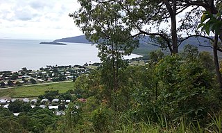
The Aboriginal Shire of Lockhart River is a local government area in Far North Queensland, Australia.

<span class="mw-page-title-main">Aboriginal Shire of Napranum</span> Local government area in Queensland, Australia

The Aboriginal Shire of Napranum is a local government area in Far North Queensland, Australia. It is on the western side of the Cape York Peninsula around Weipa.

The Mimungkum were an indigenous Australian people of Cape York Peninsula in northern Queensland.

The Wikepa are an indigenous Australian people, one of the Wik tribes of the Cape York Peninsula of northern Queensland.

References

  1. 1 2 "3218.0 – Regional Population Growth, Australia, 2017-18: Population Estimates by Local Government Area (ASGS 2018), 2017 to 2018". Australian Bureau of Statistics. Australian Bureau of Statistics. 27 March 2019. Retrieved 25 October 2019. Estimated resident population, 30 June 2018.
  2. "History". Aurukun Shire Council.
  3. Cribb, Margaret (December 1978). "Australian Political Chronicle: January-June 1978". Australian Journal of Politics and History. 24 (3): 371–372. ISSN   0004-9522.
  4. 1 2 3 4 CC BY icon-80x15.png This Wikipedia article incorporates text from Wik Mungkan Indigenous Knowledge Centre (22 November 2022) by Indigenous services published by the State Library of Queensland under CC BY licence , accessed on 18 January 2023.
  5. "Aurukun Shire Council". Public Libraries Connect. 2 February 2018. Retrieved 2 February 2018.
  6. "2008 Aurukun Shire - Mayoral Election - Election Summary". Electoral Commission of Queensland. 31 August 2010. Retrieved 30 May 2016.
  7. "2012 Aurukun Shire - Postponed Mayoral Election - Election Summary". Electoral Commission of Queensland. 24 October 2012. Retrieved 30 May 2016.
  8. "2016 Aurukun Shire Council - Mayoral Election - Election Summary". Electoral Commission of Queensland. 19 April 2016. Retrieved 30 May 2016.
  9. "2020 Local Government Elections: Saturday, 28 March 2020". Electoral Commission of Queensland. 2020. Archived from the original on 16 June 2020. Retrieved 16 June 2020.

13°21′30″S141°43′41″E / 13.35833°S 141.72806°E / -13.35833; 141.72806