Barcaldine Region

Last updated

Barcaldine Region
Queensland
Barcaldine Regional Council LGA Qld.png
Location within Queensland
Population2,852 (2018) [1]
 • Density0.053425/km2 (0.138371/sq mi)
Established2008
Area53,383 km2 (20,611.3 sq mi) [1]
MayorSean Micheal Dillion
Council seat Barcaldine
Region Central West Queensland
State electorate(s) Gregory
Federal division(s) Maranoa
Barcaldine regional council.svg
Website Barcaldine Region
LGAs around Barcaldine Region:
Winton Flinders Charters Towers
Longreach Barcaldine Region Isaac /
Central Highlands
Longreach Blackall-Tambo Central Highlands

The Barcaldine Region is a local government area in Central West Queensland, Australia. Established in 2008, it was preceded by three previous local government areas which had existed for over a century.

Contents

It has an estimated operating budget of A$21.6 million.

History

Barcaldine Region includes the traditional tribal lands of the Iningai. Iningai (also known as Yiningay, Muttaburra, Tateburra, Yinangay, Yinangi) is an Australian Aboriginal language spoken by the Iningai people. The Iningai language region includes the landscape within the local government boundaries of the Longreach Region and Barcaldine Region, particularly the towns of Longreach, Barcaldine, Muttaburra and Aramac as well as the properties of Bowen Downs and catchments of Cornish Creek and Alice River. [2]

Kuungkari (also known as Kungkari and Koonkerri) is a language of Western Queensland. The Kuungkari language region includes the landscape within the local government boundaries of Longreach Shire Council and Blackall-Tambo Shire Council. [3]

Jirandali (also known as Yirandali, Warungu, Yirandhali) is an Australian Aboriginal language of North-West Queensland, particularly the Hughenden area. The language region includes the local government area of the Shire of Flinders, including Dutton River, Flinders River, Mount Sturgeon, Caledonia (in the Barcaldine Region), Richmond, Corfield, Winton, Torrens, Tower Hill, Landsborough Creek, Lammermoor Station, Hughenden, and Tangorin. [4]

Prior to the 2008 amalgamation, the Barcaldine Region existed as three distinct local government areas:

When the Divisional Boards Act 1879 was proclaimed on 11 November 1879, what is now the Barcaldine Region was part of the Barcaldine, Aramac, Kargoolnah and Bauhinia divisions. With the passage of the Local Authorities Act 1902, all four became Shires on 31 March 1903. A number of boundary changes took place thereafter, but by the establishment of the Shire of Jericho on 1 January 1916, the boundaries were to remain unchanged for 92 years.

In July 2007, the Local Government Reform Commission released its report and recommended that the three areas amalgamate. All three councils were rated as weak to moderate in terms of financial sustainability, and the three areas were believed to form a collective community of interest with the town of Barcaldine serving as a regional centre with commercial facilities and an airport. All three councils opposed the amalgamation, with Aramac putting an alternate suggestion together with the Shire of Winton. [5] On 15 March 2008, the three Shires formally ceased to exist, and elections were held on the same day to elect councillors and a mayor to the Regional Council.

On 22 November 2019 the Queensland Government decided to amalgamate the localities in the Barcaldine Region, resulting in five expanded localities based on the larger towns: [6] [7] [8]

Wards

The council is undivided, with six councillors and a mayor serving the whole region.

Towns and localities

The Barcaldine Region includes the following settlements:

Mayors

2008–2020 : Rob Chandler [9] [10] [11]

2020–present: Sean Micheal Dillion [12]

Population

The populations given relate to the component entities prior to 2008. The 2011 census was the first for the new Region.

YearPopulation
(Total)
(Barcaldine)(Aramac)(Jericho)
19335,9052,6121,6791,614
19475,2182,1471,5921,479
19545,5142,2001,7141,600
19615,7972,3841,7901,623
19665,4352,2821,6521,501
19714,4561,8681,1681,420
19764,0591,7801,0591,220
19814,0421,7831,0821,177
19863,9811,7791,0971,105
19913,7621,8138321,117
19963,5941,850778966
20013,5361,7737421,021
20063,2641,818754920
20113,215
20162,865

Services

In cooperation with Rural Libraries Queensland, Barcaldine Regional Council operate libraries in Alpha, Aaramac, Barcaldine (headquarters), Jericho, and Muttaburra. [13]

Related Research Articles

<span class="mw-page-title-main">Barcaldine, Queensland</span> Town in Queensland, Australia

Barcaldine is a rural town and locality in the Barcaldine Region in Queensland, Australia. This is the administrative centre of the Barcaldine Region. Barcaldine played a major role in the Australian labour movement.

<span class="mw-page-title-main">Aramac, Queensland</span> Town in Queensland, Australia

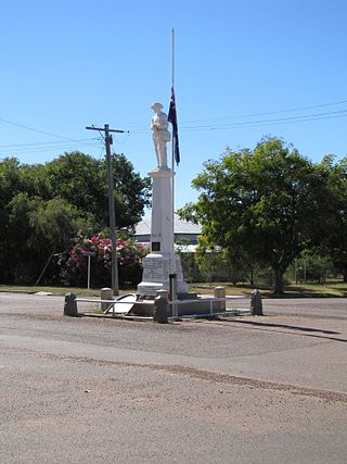
Aramac is a rural town and locality in the Barcaldine Region, Queensland, Australia. In the 2016 census, Aramac had a population of 299 people.

<span class="mw-page-title-main">Muttaburra</span> Town in Queensland, Australia

Muttaburra is an outback town and locality in the Barcaldine Region, Queensland, Australia. Muttaburra was the discovery site of the Muttaburrasaurus, one of Australia's most famous dinosaurs.

<span class="mw-page-title-main">Shire of Aramac</span> Local government area in Queensland, Australia

The Shire of Aramac was a local government area located in central Queensland about 1,100 kilometres (684 mi) north west of the state capital, Brisbane, between the towns of Barcaldine and Winton. It covered an area of 23,364.1 square kilometres (9,020.9 sq mi), and existed as a local government entity from 1879 until 2008, when it amalgamated with the Shires of Barcaldine and Jericho to form the Barcaldine Region.

<span class="mw-page-title-main">Shire of Jericho</span> Local government area in Queensland, Australia

The Shire of Jericho was a local government area in central Queensland between the towns of Barcaldine and Emerald. Administered from the town of Alpha, the Shire covered an area of 21,864.9 square kilometres (8,442.1 sq mi), and existed as a local government entity from 1916 until 2008, when it amalgamated with the Shires of Aramac and Barcaldine to form the Barcaldine Region.

<span class="mw-page-title-main">Longreach Region</span> Local government area in Queensland, Australia

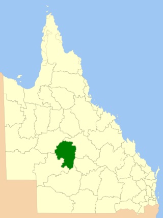
The Longreach Region is a local government area in Central West Queensland, Australia. Established in 2008, it superseded three previous local government areas that had existed for more than a century.

<span class="mw-page-title-main">Alice River (Barcoo River tributary)</span> River in Queensland, Australia

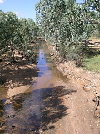
The Alice River in central Queensland, Australia rises on the western slopes of the Great Dividing Range. The river bisects the Shire of Barcaldine, flowing in a south-westerly direction towards Isisford and its confluence with the Barcoo River. The town of Barcaldine is located on the Alice River. The Alice River's tributaries include Jordan Creek and Lagoon Creek. The Alice River is often dry, except after the annual summer rains.

<span class="mw-page-title-main">Bowen Downs Station</span>

Bowen Downs Station is a pastoral lease that has operated both as a cattle station and a sheep station.

<span class="mw-page-title-main">Cornish Creek, Queensland</span> Suburb of Barcaldine Region, Queensland, Australia

Cornish Creek is a former rural locality in the Barcaldine Region, Queensland, Australia. In the 2016 census, Cornish Creek had a population of 16 people.

Tablederry is a former rural locality in the Barcaldine Region, Queensland, Australia. In the 2016 census, Tablederry had a population of 32 people.

Bangall is a former rural locality in the Barcaldine Region, Queensland, Australia. In the 2016 census, Bangall had a population of 4 people.

Upper Cornish Creek is a former rural locality in the Barcaldine Region, Queensland, Australia. In the 2016 census, Upper Cornish Creek had a population of 43 people.

Ingberry is a former rural locality in the Barcaldine Region, Queensland, Australia. In the 2016 census, Ingberry had a population of 11 people.

Sardine is a former rural locality in the Barcaldine Region, Queensland, Australia. In the 2016 census, Sardine had a population of 5 people.

<span class="mw-page-title-main">Barcaldine Downs</span> Suburb of Barcaldine Region, Queensland, Australia

Barcaldine Downs is a former rural locality in the Barcaldine Region, Queensland, Australia. In the 2016 census, Barcaldine Downs had a population of 14 people.

Evora is a former rural locality in the Barcaldine Region, Queensland, Australia. In the 2016 census, Evora had a population of 0 people.

Patrick is a former rural locality in the Barcaldine Region, Queensland, Australia. In the 2016 census, Patrick had a population of 26 people.

Tara Station is a former rural locality in the Barcaldine Region, Queensland, Australia. In the 2016 census, Tara Station had a population of 10 people.

Dunrobin is a former rural locality in the Barcaldine Region, Queensland, Australia. In the 2016 census, Dunrobin had a population of 14 people.

<span class="mw-page-title-main">Hobartville, Queensland</span> Suburb of Barcaldine Region, Queensland, Australia

Hobartville is a former rural locality in the Barcaldine Region, Queensland, Australia. In the 2016 census, Hobartville had a population of 50 people.

References

  1. 1 2 "3218.0 – Regional Population Growth, Australia, 2017-18: Population Estimates by Local Government Area (ASGS 2018), 2017 to 2018". Australian Bureau of Statistics. Australian Bureau of Statistics. 27 March 2019. Archived from the original on 27 March 2019. Retrieved 25 October 2019. Estimated resident population, 30 June 2018.
  2. "Iningai". State Library of Queensland . Retrieved 15 January 2020.
  3. CC BY icon-80x15.png This Wikipedia article incorporates CC-BY-4.0 licensed text from: "Queensland Aboriginal and Torres Strait Islander languages map". State Library of Queensland. State Library of Queensland . Retrieved 30 January 2020.
  4. CC BY icon-80x15.png This Wikipedia article incorporates CC-BY-4.0 licensed text from: "Guugu Yimithirr". Queensland Aboriginal and Torres Strait Islander languages map. State Library of Queensland . Retrieved 28 January 2020.
  5. Queensland Local Government Reform Commission (July 2007). Report of the Local Government Reform Commission (PDF). Vol. 2. pp. 22–26. ISBN   978-1-921057-11-3. Archived (PDF) from the original on 17 March 2011. Retrieved 3 June 2010.
  6. "Recent place name decisions". Queensland Government. 22 November 2019. Archived from the original on 22 October 2019. Retrieved 15 January 2020.
  7. "Proposed Locality Boundaries and Names: Barcaldine Regional: Alpha, Aramac, Barcaldine, Jericho and Muttaburra" (PDF). Queensland Government. 17 May 2019. Archived from the original (PDF) on 15 January 2020. Retrieved 15 January 2020.
  8. "Locality Boundaries and Names: Barcaldine Regional Council: Alpha, Aramac, Barcaldine, Jericho and Muttaburra" (PDF). Queensland Government. 17 May 2019. Archived from the original (PDF) on 15 January 2020. Retrieved 15 January 2020.
  9. "2008 Barcaldine Regional Council - Mayoral Election - Election Summary". Electoral Commission of Queensland. 31 August 2010. Archived from the original on 29 March 2016. Retrieved 16 March 2017.
  10. "2012 Barcaldine Regional Council - Mayoral Election - Election Summary". Electoral Commission of Queensland. 27 May 2012. Archived from the original on 8 May 2016. Retrieved 16 March 2017.
  11. "2016 Barcaldine Regional Council - Mayoral Election - Election Summary". Electoral Commission of Queensland. 19 April 2016. Archived from the original on 25 April 2016. Retrieved 16 March 2017.
  12. "2020 Local Government Elections: Saturday, 28 March 2020". Electoral Commission of Queensland. 2020. Retrieved 16 June 2020.[ dead link ]
  13. "Libraries". Barcaldine Regional Council. Archived from the original on 7 June 2017. Retrieved 8 May 2017.

Coordinates: 23°34′S145°17′E / 23.567°S 145.283°E / -23.567; 145.283