Redland City

Last updated

Redland City
Queensland
RedlandCity-QldLGA.svg
Location within South East Queensland
Redland City
Population156,863 (2018) [1]  (46th)
 • Density292.001/km2 (756.28/sq mi)
Established1948
Area537.2 km2 (207.4 sq mi) [1]
MayorKaren Williams
Council seat Cleveland
Region South East Queensland
State electorate(s)
Federal division(s) Bowman
Redlands city council.svg
Website Redland City
LGAs around Redland City:
Brisbane Moreton Bay Brisbane (Moreton Island)
Brisbane Redland City Coral Sea
Logan Gold Coast Coral Sea

Redland City, better known as the Redlands and formerly known as Redland Shire, is a local government area and a part of the Brisbane metropolitan area in South East Queensland, Australia. With a population of 159,222 in June 2021, the city is spread along the southern coast of Moreton Bay, covering 537.2 square kilometres (207.4 sq mi). Its mainland borders the City of Brisbane to the west and north-west, and Logan City to the south-west and south, while its islands are situated north of the City of Gold Coast.

Contents

Redland attained city status on 15 March 2008, having been a shire since 1949, when it was created by the merger of the former Tingalpa and Cleveland Shires. [2] Despite this status, the City consists of largely suburban and coastal communities, featuring a somewhat disjointed urbanisation around major suburbs interspersed with bushland; there is no clear city centre.

Large mainland suburbs include Capalaba, Cleveland, Victoria Point, Thornlands, and Redland Bay. The latter is the city's namesake, due to the colour of its fertile soil. [3] North Stradbroke Island and smaller nearby islands, most notably those of Southern Moreton Bay, comprise the eastern portion of the Redlands. The city's boundaries correspond to those of the federal division of Bowman.

History

St Pauls Anglican Church in Cleveland, ca. 1905 StateLibQld 1 118616 St. Paul's Church of England, Cleveland, ca. 1905.jpg
St Pauls Anglican Church in Cleveland, ca. 1905

The area now known as the Redlands was initially inhabited by the Jagera, Turrbal, and Quandamooka people. [4] Some locations derive their names from Aboriginal languages, and known historic sites within the area include a bora ring at Mount Cotton. [5] [6] The Quandamooka are recognised as the traditional custodians of North Stradbroke Island, and more recently applied for native title over much of the Redlands' surrounding islands and mainland. [7] [8]

Jandai (also known as Janday, Jandewal, Djendewal, Jundai, Goenpul and Jandawal), is one of the Aboriginal languages used on Stradbroke Island. [9]

Europeans first entered the Redlands in the late 18th century while mapping Moreton Bay: James Cook made observations of the then-undivided Stradbroke Island; Matthew Flinders landed on Coochiemudlo Island in 1799; and Robert Dixon later surveyed and named much of the area.

By the 1840s, the coastal township of Cleveland was in contention to become a major port replacing Brisbane, but was ultimately not chosen due to the region's existing sandbars and shipwrecks, and an unfavourable review from Governor George Gipps during his 1842 visit. Louis Hope and other land purchasers began to develop significant infrastructure at this time. On 11 November 1879, under the Divisional Boards Act 1879, the Tingalpa Division was created to govern the area to the east of metropolitan Brisbane. The area around Cleveland split away to form the Cleveland Division on 30 May 1885. Under the Local Authorities Act 1902, both became Shires on 31 March 1903. The Tingalpa council met at Mount Cotton.

On 1 October 1925, a sizeable portion of the Shire of Tingalpa (suburbs west of Tingalpa Creek, including Upper Mount Gravatt and Rochedale) became part of the new City of Brisbane along with 20 other local governments. [10] [11] On 9 December 1948, as part of a major reorganisation of local government in South East Queensland, an Order in Council renamed the Shire of Cleveland to be Shire of Redland and amalgamated part of Shire of Tingalpa into it (the other part of Tingalpa amalgamated to form the Shire of Albert). [12]

The twentieth century saw significant population growth in the Redlands, preceded by the construction of the Cleveland railway line. Peel Island became a leper colony, while North Stradbroke Island became a hub for sand mining, and is also associated with the Indigenous rights movement as the home of poet Oodgeroo Noonuccal and academic Aileen Moreton-Robinson. On 15 March 2008, Redlands was granted city status. [13] [14]

In June 2018, the Redland City Council approved a marketing campaign to brand the city as "Redlands Coast" with the tagline "naturally wonderful". The campaign seeks to attract tourists to the city's 335 kilometres (208 mi) of coastline (due to a number of islands which form part of the city). [15]

Geography

Satellite view from the southwest of Southern Moreton Bay, Queensland - labelled are the many islands created from the outflow of the Logan River behind the barrier of North and South Stradbroke Islands Bay Islands.jpg
Satellite view from the southwest of Southern Moreton Bay, Queensland – labelled are the many islands created from the outflow of the Logan River behind the barrier of North and South Stradbroke Islands

Although most of the population resides on the main urban conglomeration based around the centres of Capalaba, Cleveland and Victoria Point, over 6,000 people live on islands in Moreton Bay that are part of the city. These are North Stradbroke, Coochiemudlo and the Southern Moreton Bay Islands of Karragarra, Lamb, Russell and Macleay. Tingalpa Creek rises on Mount Cotton, forming Leslie Harrison Dam, and marking the majority of the area's western boundary. [16]

Environment

Redland City has many immediately recognisable animals and plants such as koalas, migratory shorebirds, flying foxes and scribbly gum forests. It is also home to over 1,700 other recorded native species, many of which are under threat from population growth and its associated effects such as habitat clearing and fragmentation, road construction, pollution and expanding development. [17] The council area is also home to Venman Bushland National Park, and the Eprapah Scout environment training centre.

One of Redland City's koalas 116 Koala HZP 14 February 2015 comp.jpg
One of Redland City's koalas

In April 2013, the Redland City Council illegally cleared vegetation from public land on the foreshores of Moreton Bay. The council has been required by the State Government to restore the cleared vegetation and install signage about the restoration. [18] Trees felled included many sheoaks. [19]

The city's koala population has declined significantly in recent years. In 2010, it was estimated that only 2,000 koalas remained, a 65% decline since 1999. Figures from a count in 2012 have not yet been released by the Queensland Government. [20] The Redland City-based Koala Action Group has warned that: "Rampant expansion of urban areas will lead to the loss of the koala populations that are vital to the long-term survival of the species." [21]

The city boundaries include internationally significant coastal wetlands within the Moreton Bay Ramsar site. Tidal flats, mangroves and seagrass beds provide important habitats for fish, crustaceans, and:

Hilliards Creek, flowing from Moreton Bay, separating the suburbs of Wellington Point (left) and Ormiston (right) Hillards Creek at Ormiston Park.jpg
Hilliards Creek, flowing from Moreton Bay, separating the suburbs of Wellington Point (left) and Ormiston (right)

Freshwater systems in the Redlands catchment do not meet set ecosystem health values, according to the Healthy Waterways Report Cards for both 2013 and 2014. [25] [26]

Fire ants have been detected in a number of Redland City suburbs, with Sheldon and Mount Cotton being assessed by BioSecurity Queensland as high-risk, and requiring treatment by ground teams. [27]

Transport

Wellington Point station, the Redlands' third stop along the Cleveland line Wellington Point Railway Station, Queensland, Aug 2012.JPG
Wellington Point station, the Redlands' third stop along the Cleveland line

Queensland Rail operates the Cleveland railway line, which connects the Redlands with Brisbane as part of its City network. The line runs parallel with the Brisbane River to its south, passing through Brisbane's Cannon Hill and Wynnum, before crossing Tingalpa Creek to enter Redland City. Northern suburbs of the city are serviced by five stations: Thorneside, Birkdale, Wellington Point, Ormiston, and Cleveland, where the line terminates.

The TransLink (South East Queensland) bus network is prevalent in the Redlands. Bus stations at Capalaba and Victoria Point feature regular city-bound and outbound connections, with direct services to Carindale, Eight Mile Plains, Loganholme, and the Brisbane CBD during peak hour.

Plans for extending the Eastern Busway to Capalaba bus station were "paused" in 2011 but a new planning study commenced in 2022. [28]

The Gateway Motorway and Pacific Motorway are located further west within the City of Brisbane. Major roads are accessible from these highways, such as Old Cleveland Road, Mount Gravatt-Capalaba Road, and Mount Cotton Road, which enter the Redlands from Chandler, Burbank, and Cornubia, respectively.

Culture and heritage

Redland Museum, viewed from the Cleveland Showgrounds Redland Museum.jpg
Redland Museum, viewed from the Cleveland Showgrounds

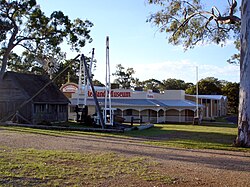
Redland City has a number of important cultural facilities, including the Redland Art Gallery, Redland Museum, and Redland Performing Arts Centre.

The city also has many heritage-listed sites, [29] including:

Libraries

The Redland City Council operate public libraries at Amity Point, Capalaba, Cleveland, Dunwich, Point Lookout, Russell Island and Victoria Point. [31] There is a mobile library serving Alexandra Hills, Mount Cotton Park, Redland Bay, Thorneside, Victoria Point, and Wellington Point. [32]

Economy

Raby Bay Marina, viewed from the centre of Cleveland Cleveland Harbour.jpg
Raby Bay Marina, viewed from the centre of Cleveland

For the year ending 30 June 2014, Redland City's Gross Regional Product (GRP) was estimated to be 4.77 billion dollars. [33]

Year (Ending June)Redland City  % Change in GRPQueensland –  % Change in GRP
20141.71.7
20131.72.6
20125.06.2
20111.60.7
20102.00.0
20091.00.6
Eastern curlew visiting the shore of Cleveland Wiki Eastern Curlew Oyster Pt Cleveland 112 edit 2 comp.jpg
Eastern curlew visiting the shore of Cleveland

Key industry sectors include health care and social assistance, retail trade, education and training, sand mining, construction and tourism.

During the year ending in June 2014, an estimated 41,506 jobs were located in Redland City, [34] along with an estimated 74,089 employed residents, [35] meaning 32,035 (or 47.1%) of Redland City's employed residents who work travel outside of the area to do so. [36]

Year (Ending June)Redland City – Employed ResidentsRedland City – Local Jobs
201474,08941,506
201374,14141,788
201274,63343,138
201173,86343,485
201073,03342,888
200973,20741,829

Mining

North Stradbroke Island's beaches Straddie.jpg
North Stradbroke Island's beaches

North Stradbroke Island, one of the world's largest sand islands, has been the subject of sand mining operations since 1949. [37] In 2010, Queensland's Labor Government announced a phase-out of the sand mining industry over a 17-year period, with up to 80% of the island to be covered by national park. In April 2011, the government then extended key expired mining leases to allow mining to continue at the main Enterprise sand mine until the end of 2019, while Sibelco was interested in an extension to 2027. [38] 2013 saw the LNP Government pass legislation allowing sand mining on the island for an extra 16 years: from 2019 to 2035. [39] For mining to continue past 2019 at the Enterprise sand mine, the lease owner (currently Sibelco) would have to apply for an extension in 2019, under legislative amendments passed by the Newman Government in November 2013. However, if the amendments are repealed by a future government before 2019, the mine will close on 31 December 2019, the closure date legislated by the government in April 2011. [40]

The circumstances leading up to this legislative amendment have been referred to Queensland's Crime and Misconduct Commission. [41] On 6 June 2014, North Stradbroke Island's traditional owners, the Quandamooka people, initiated a legal challenge saying, on the grounds that the LNP Government's extension of mining contravened the Federal Native Title Act. [42] In May 2016, legislation passed by the Palaszczuk Ministry did confirm that sand mining on North Stradbroke will end by 2019. [43] [44]

Mainland quarries are located in the suburb of Mount Cotton, [45] [46] and have drawn their own criticisms concerning allegations of pollution [47] and OHS breaches. [48]

Development

Protest against the planned marina and high-rise buildings in Cleveland Protest against Toondah PDA plan 23 February 2014.jpg
Protest against the planned marina and high-rise buildings in Cleveland

Toondah Harbour in Cleveland is the location of the Stradbroke Island Ferry Terminal, used by water taxis and vehicular ferries to provide access to North Stradbroke Island. Cleveland's Toondah Harbour and Redland Bay's Weinam Creek were declared Priority Development Areas (PDAs) under the Economic Development Act 2012 on 21 June 2013. PDA designation allows development to be fast-tracked, but also means that local communities and interest groups have less opportunity to comment on issues of concern. [49]

The Government and Redland City Council have proposed PDA development schemes which have attracted community opposition. On 23 February, approximately 30 people attended a rally to protest against the Government's plans to "carve up" the G.J. Walter Park as part of its Toondah Harbour redevelopment proposal. [50] On 4 March 2014 a petition with 1,211 signatures calling for the Government's Toondah Harbour PDA plan to be withdrawn was tabled in the Queensland Parliament. [51]

On 31 May 2014, an approved development scheme was released [52] together with a lengthy report on the 583 submissions received during the consultation period. [53]

On 18 September 2014, the Government and Council announced that Walker Corporation had been selected as preferred developer for both the Toondah Harbour and Weinam Creek priority development areas. [54]

In the 2016 census, the population of the Redland City was 147,010. [55] The median age was 41 years old, 3 years older than the nationwide median. The male-to-female ratio was 49-to-51. The most commonly nominated ancestries were English (32.1%), Australian (25.2%), Irish (9.0%), Scottish (8.6%), and German (4.5%). 72.5% of people were born in Australia, while the other most common countries of birth were England (6.7%), New Zealand (5.4%), South Africa (1.7%), Scotland (0.9%), and the Philippines (0.5%). Indigenous Australians accounted for 2.3% of the population. The most commonly spoken languages other than English were Afrikaans and Mandarin (0.5% each), German (0.4%), and Italian and Spanish (0.3% each). The most common religious affiliations reported were none (29.8%), Catholic (21.1%), Anglican (17.9%), and Uniting Church (6.1%). [55]

Entrance to the Capalaba Library, 2008 Capalaba Library.jpg
Entrance to the Capalaba Library, 2008

Council

Redland City Council has a Mayor, and a Councillor for each of its 10 divisions. [56] Elections are held every four years and voting is compulsory.

Karen Williams was elected mayor at the 2012 election. She pledged to cap rate rises to inflation, control debt, abolish fees to dump rubbish at local tips, and make the council more transparent and accountable. [57]

Williams was re-elected at the 2016 local government election and the 2020 local government elections. [58] [59]

On 23 June 2022 Williams crashed her car after drinking "several glasses of wine" following the Council's Budget meeting. [60] She was charged with drink driving after returning a Blood Alcohol Concentration of 0.177 per cent, three times the legal limit. [61] Appearing in the Cleveland Magistrates Court on 1 August 2022 Karen Williams pleaded guilty to drink driving and was sentenced to 80 hours of community service and disqualified from driving for six months. [62] Karen Williams announced on 9 December 2023 that she would not seek re-election at the March 2024 local government elections. [63]

Councillor [59] Declared political membershipTermConstituency
Karen Williams Liberal National Party [64] 2012–presentMayor
Wendy BoglaryIndependent2008–presentDivision 1
Peter MitchellIndependent2016–presentDivision 2
Paul GollèIndependent2016–presentDivision 3
Lance HewlettIndependent2012–presentDivision 4
Mark EdwardsIndependent2012–presentDivision 5
Julie TaltyIndependent2012–presentDivision 6
Rowanne McKenzieIndependent2020–presentDivision 7
Tracey HugesIndependent2016–presentDivision 8
Adelia BerridgeIndependent2020–presentDivision 9
Paul Bishop Independent2012–presentDivision 10

Mayors

Other notable members of the Redland Council include:

Suburbs

Redland City consists of the following suburbs and localities: [66]

View east, towards Redland and Moreton Bay, from Mount Cotton, 2014 View towards Moreton Bay from Mount View Road.jpg
View east, towards Redland and Moreton Bay, from Mount Cotton, 2014
Shoreline of Brown Lake on North Stradbroke Island Brown Lake (North Stradbroke Island).JPG
Shoreline of Brown Lake on North Stradbroke Island
Cassim Island, viewed from G.J. Walter Park in Cleveland Cassim Island at Sunrise viewed from G.J. Walter Park.JPG
Cassim Island, viewed from G.J. Walter Park in Cleveland

Redland City also includes a number of uninhabited or sparsely populated islands in Moreton Bay, including: [67]

Population

Picnic area of Venman Bushland National Park in Mount Cotton Venman Bushland National Park picnic area.jpg
Picnic area of Venman Bushland National Park in Mount Cotton

The following table lists of the population of Redland City and its predecessor local government areas:[ citation needed ]

YearPopulation
19475,211
19547,365
196110000
196612,632
197116,672
197627,539
198142,527
198658,501
199180,690
1996100,101
2001117,252
2006131,210
2012145,336
2016147,010
2020160,331
2021159,222

Related Research Articles

<span class="mw-page-title-main">Moreton Bay</span> Inlet in southern Queensland, Australia

Moreton Bay is a bay located on the eastern coast of Australia 14 kilometres (8.7 mi) from central Brisbane, Queensland. It is one of Queensland's most important coastal resources. The waters of Moreton Bay are a popular destination for recreational anglers and are used by commercial operators who provide seafood to market.

<span class="mw-page-title-main">North Stradbroke Island</span> Island that lies within Moreton Bay in the Australian state of Queensland

North Stradbroke Island, colloquially Straddie or North Straddie, is an island that lies within Moreton Bay in the Australian state of Queensland, 30 kilometres (19 mi) southeast of the centre of Brisbane. Originally there was only one Stradbroke Island but in 1896 it split into North Stradbroke Island and South Stradbroke Island separated by the Jumpinpin Channel. The Quandamooka people are the traditional owners of North Stradbroke island.

<span class="mw-page-title-main">Mount Cotton, Queensland</span> Locale in Queensland, Australia

Mount Cotton is a rural locality in the City of Redland, Queensland, Australia. In the 2016 census, Mount Cotton had a population of 6,835 people.

<span class="mw-page-title-main">Cleveland railway station</span> Railway station in Queensland, Australia

Cleveland railway station is located on the Cleveland line in Queensland, Australia. It serves the suburb of Cleveland in the Redland City.

<span class="mw-page-title-main">Capalaba, Queensland</span> Suburb of Redland City, Queensland, Australia

Capalaba is an urban locality in the City of Redland, Queensland, Australia. In the 2021 census, Capalaba had a population of 18,002 people.

<span class="mw-page-title-main">Tingalpa, Queensland</span> Suburb of Brisbane, Queensland, Australia

Tingalpa is a suburb in the City of Brisbane, Queensland, Australia. In the 2016 census, Tingalpa had a population of 8,290 people.

<span class="mw-page-title-main">South East Queensland</span> Region in southern Queensland, Australia

South East Queensland (SEQ) is a bio-geographical, metropolitan, political and administrative region of the state of Queensland in Australia, with a population of approximately 3.8 million people out of the state's population of 5.1 million. The area covered by South East Queensland varies, depending on the definition of the region, though it tends to include Queensland's three largest cities: the capital city Brisbane; the Gold Coast; and the Sunshine Coast. Its most common use is for political purposes, and covers 35,248 square kilometres (13,609 sq mi) and incorporates 11 local government areas, extending 240 kilometres (150 mi) from Noosa in the north to the Gold Coast and New South Wales border in the south, and 140 kilometres (87 mi) west to Toowoomba. It is the third largest urban area in Australia by population.

<span class="mw-page-title-main">Cleveland, Queensland</span> Suburb of Redland City, Queensland, Australia

Cleveland is a coastal and central locality in the City of Redland, Queensland, Australia. In the 2016 census, Cleveland had a population of 14,801 people.

<span class="mw-page-title-main">Dunwich, Queensland</span> Town in Queensland, Australia

Dunwich is a town and locality on the western side of North Stradbroke Island in Queensland, Australia. Dunwich is part of the Redland City local government area, administered from the bayside town of Cleveland on the Queensland mainland. In the 2016 census, Dunwich had a population of 864 people.

Amity is a rural town and locality in the City of Redland, Queensland, Australia. In the 2016 census, the locality of Amity had a population of 387 people.

<span class="mw-page-title-main">Chandler, Queensland</span> Suburb of Brisbane, Queensland, Australia

Chandler is an outer south-eastern suburb in the City of Brisbane, Queensland, Australia. In the 2016 census, Chandler had a population of 1,442 people.

<span class="mw-page-title-main">Ransome, Queensland</span> Suburb of Brisbane, Queensland, Australia

Ransome is an outer coastal suburb in the City of Brisbane, Queensland, Australia. In the 2016 census, Ransome had a population of 405 people.

<span class="mw-page-title-main">Ferry transport in Queensland</span>

The article Ferry transport in Queensland provides both historical and current information relating to scheduled public passenger ferry services in Queensland. The first ferry started on 1 January 1843 at Russell Street with a service across the Brisbane River.

<span class="mw-page-title-main">Sheldon, Queensland</span> Suburb of Redland City, Queensland, Australia

Sheldon is a rural residential locality in the City of Redland, Queensland, Australia. In the 2016 census, Sheldon had a population of 1,704 people.

<span class="mw-page-title-main">Tingalpa Creek</span> River in Queensland, Australia

Tingalpa Creek is a creek in South East Queensland. It flows along Brisbane's south east boundary with Redland City Council. On early maps the creek was called both Tunim Creek and Tangulba Creek.

<span class="mw-page-title-main">Old Cleveland Road</span> Road in Brisbane, Australia

Old Cleveland Road is a major road in Brisbane, Queensland. It runs 19.3 kilometres (12.0 mi) from Stones Corner to Capalaba in Brisbane, with most of the route signed as State Route 22. Sections of the road are also part of State Routes 30, 54, and 55. The road is the main route from inner Brisbane to Capalaba and Cleveland since New Cleveland Road only links Tingalpa with Capalaba.

<span class="mw-page-title-main">Shire of Cleveland</span>

The Shire of Cleveland is a former local government area in the south-east of Queensland, Australia, centred on the town of Cleveland beside Moreton Bay.

<span class="mw-page-title-main">Toondah Harbour</span> Suburb of Cleveland, Queensland, Australia

Toondah Harbour is a boat harbour at Cleveland in Redland City, Queensland, Australia. It is in southern Moreton Bay. It is the location of the Stradbroke Island Ferry Terminal used by water taxis and vehicular ferries to provide access to North Stradbroke Island.

<span class="mw-page-title-main">Mount Cotton Road</span>

Mount Cotton Road, or Mt Cotton Rd, is a major split road in the Brisbane area of South East Queensland, Australia. It runs in both an east-west direction between Burbank (Brisbane) and Sheldon (Redlands), and a north-south direction between Capalaba (Redlands) and Carbrook (Logan). In total, the road is approximately 26.5 kilometres (16.5 mi) long, and is split at a three-way roundabout.

Cleveland–Redland Bay Road is a continuous 15.2 kilometres (9.4 mi) road route in the Redland local government area of Queensland, Australia. The route is designated as part of State Route 47. It is a state-controlled district road rated as a local road of regional significance (LRRS).

References

  1. 1 2 "3218.0 – Regional Population Growth, Australia, 2017–18: Population Estimates by Local Government Area (ASGS 2018), 2017 to 2018". Australian Bureau of Statistics. Australian Bureau of Statistics. 27 March 2019. Archived from the original on 27 March 2019. Retrieved 25 October 2019. Estimated resident population, 30 June 2018.
  2. Queensland State Archives, Search for Agency Details of Redland City Council Archived 27 January 2014 at the Wayback Machine , Retrieved 7 April 2014
  3. David Tuffley, 2007, "Redland Bay, Australia: Introduction", Griffith University: "Redland Bay: Introduction". Archived from the original on 24 September 2015. Retrieved 6 September 2015., Retrieved 7 September 2015
  4. "The Turrbal and Jagera People". 26 June 2014. Archived from the original on 12 July 2021. Retrieved 12 July 2021.
  5. "Aboriginal cultural heritage in the Redlands". Archived from the original on 12 July 2021. Retrieved 12 July 2021.
  6. "Aboriginal history of Rochedale". Archived from the original on 12 July 2021. Retrieved 12 July 2021.
  7. "Quandamooka Country Map". Archived from the original on 23 November 2020. Retrieved 12 July 2021.
  8. "QYAC Native Title". Archived from the original on 12 July 2021. Retrieved 12 July 2021.
  9. "Queensland Aboriginal and Torres Strait Islander languages map". State Library of Queensland. 2020. Archived from the original on 5 September 2020. Retrieved 23 January 2020.
  10. Queensland Places, "Tingalpa", Centre for the Government of Queensland, University of Queensland: "Tingalpa | Queensland Places". Archived from the original on 22 February 2015. Retrieved 22 February 2015., Retrieved 19 May 2015
  11. City of Brisbane Act 1924 Archived 13 March 2011 at the Wayback Machine (accessed 19 May 2015)
  12. Queensland Places, "Redland City", Centre for the Government of Queensland, University of Queensland: "Redland City | Queensland Places". Archived from the original on 20 May 2015. Retrieved 19 May 2015., Retrieved 19 May 2015
  13. Redland City Council, "Redlands City Community Plan Project Proposal", 18 March 2008: "Archived copy" (PDF). Archived (PDF) from the original on 12 April 2015. Retrieved 19 May 2015.{{cite web}}: CS1 maint: archived copy as title (link), Retrieved 19 May 2015
  14. The Redland Foundation, "About Us": "The Redland Foundation: About Us". Archived from the original on 20 May 2015. Retrieved 19 May 2015., Retrieved 19 May 2015
  15. "Redland City Council approves Redlands Coast brand and naturally wonderful tagline". Redland City Bulletin . 6 June 2018. Archived from the original on 28 August 2018. Retrieved 16 September 2018.
  16. Mary Howells, "Living on the Edge: along Tingalpa Creek a history of Upper Tingalpa, Capalaba and Thorneside", University of Queensland, 2001: "Archived copy" (PDF). Archived (PDF) from the original on 20 May 2015. Retrieved 17 July 2015.{{cite web}}: CS1 maint: archived copy as title (link), Retrieved 19 May 2015
  17. Biodiversity Strategy 2008–2012, Redland City Council, May 2008: "Biodiversity Strategy". Archived from the original on 22 February 2014. Retrieved 22 February 2014., Retrieved on 5 February 2014
  18. Judith Kerr, "Council guilty of illegal tree clearing", Redland City Bulletin, 26 July 2014: "UPDATED: Council guilty of illegal tree clearing". 26 July 2014. Archived from the original on 27 July 2014. Retrieved 26 July 2014., Retrieved 27 July 2014
  19. "Wildlife Bayside,"Council cleared protected coastal vegetation for individual ocean views?" Retrieved 27 July 2014". 9 April 2014. Archived from the original on 13 August 2014. Retrieved 26 July 2014.
  20. Tony Moore, "State Government's go-slow on Koala Coast population figures", Brisbane Times, 9 December 2013 Archived 1 March 2014 at the Wayback Machine , Retrieved on 9 March 2014
  21. KAG comments on Draft EPBC Act Referral Guidelines for the Vulnerable Koala: "KAG comments on Draft EPBC Act Referral Guidelines for the Vunerable Koala". Archived from the original on 13 March 2014. Retrieved 12 March 2014., Retrieved on 13 March 2014
  22. "Moreton Bay (Ramsar Site) Overview, Australian Government, Department of The Environment Retrieved on 5 February 2014". Archived from the original on 13 February 2014. Retrieved 5 February 2014.
  23. Migratory waterbirds, Australian Government, Department of The Environment Archived 22 February 2014 at the Wayback Machine , Retrieved 13 February 2014
  24. BAAM Ecological Consultants and FRC Environmental, "Expert Advice in Ecology (Marine and Terrestrial)and Coastal Processes for Input to the preparation of a Structure Plan and Development Scheme for Toondah Harbour and Weinam Creek Priority Development Areas": "Archived copy" (PDF). Archived (PDF) from the original on 5 May 2014. Retrieved 5 May 2014.{{cite web}}: CS1 maint: archived copy as title (link), Retrieved 5 May 2014
  25. James Kelly, "Moreton Bay's grade falls in Healthy Waterways report", ABC News, 23 October 2013: Kelly, James (23 October 2013). "Moreton Bay's grade falls in Healthy Waterways report". ABC News. Archived from the original on 10 March 2014. Retrieved 8 March 2014., Retrieved on 8 March 2014
  26. Judith Kerr, "Water report gives Redland 'F' for fail", Redland City Bulletin, 22 October 2014: "Waterway report fails Redland again". 22 October 2014. Archived from the original on 22 October 2014. Retrieved 22 October 2014., Retrieved 22 October 2014
  27. Judith Kerr, "Fire ants on the march in Redlands", Bayside Bulletin, 20 June 2013: "Fire ants on the march in Redlands | Bayside Bulletin". Archived from the original on 9 March 2014. Retrieved 9 March 2014., Retrieved on 9 March 2014
  28. Stephanie Bennett "Brisbane Metro: Funding for Eastern Metro Study to pave way for route through eastern suburbs to Capalaba", Courier Mail, 11 November 2022 "Eastern Busway". Archived from the original on 13 May 2023. Retrieved 9 April 2023.
  29. The External links section of this article includes a link to a search of the Queensland Heritage Register which gives a complete list of all heritage-listed places in Redland City.
  30. "Cleveland Lighthouse (former) (entry 600772)". Queensland Heritage Register . Queensland Heritage Council. Retrieved 12 July 2013.
  31. "Library opening hours and locations". Redland City Council . Archived from the original on 30 January 2018. Retrieved 31 January 2018.
  32. "Mobile Library". Redland City Council . Archived from the original on 30 January 2018. Retrieved 31 January 2018.
  33. .Id, Redland City Gross Product: "Gross Domestic product | Redland City | economy.id". Archived from the original on 8 April 2014. Retrieved 7 April 2014., Retrieved 18 May 2015
  34. Id, Redland City, Local Jobs: "Local employment | Redland | economy.id". Archived from the original on 18 May 2015. Retrieved 18 May 2015., Retrieved 18 May 2015
  35. Id, Redland City, Employed Residents: "Employed residents | Redland | economy.id". Archived from the original on 4 March 2016. Retrieved 18 May 2015., Retrieved 18 May 2015
  36. Id, Redland City, Residents place of work by occupation – All occupations: "Residents place of work by occupation | Redland City | economy.id". Archived from the original on 6 November 2016. Retrieved 18 May 2015.?, Retrieved 18 May 2015
  37. Queensland Historical Atlas, Mining: "Mining | Queensland Historical Atlas". Archived from the original on 24 April 2014. Retrieved 7 April 2014. , Retrieved 7 April 2014
  38. Courtney Trenwith, "Green jobs to replace mining work on Stradbroke: Bligh", Brisbane Times, 21 June 2010: "Green jobs to replace mining work on Stradbroke: Bligh". 20 June 2010. Archived from the original on 8 January 2014. Retrieved 7 April 2014. , Retrieved 7 April 2014
  39. Judith Kerr, "Straddie Act amended to allow 16 more years of mining", Bayside Bulletin, 21 November 2013: "Straddie Act amended to allow 16 more years of mining | Bayside Bulletin". Archived from the original on 8 April 2014. Retrieved 7 April 2014. , Retrieved 7 April 2014
  40. Richard Carew, "The government is lying about Stradbroke Island sand mining", Brisbane times, 15 July 2014 Archived 18 July 2014 at the Wayback Machine , Retrieved 15 July 2014
  41. Tony Moore, "Labor refers Sibelco sand mining company to CMC", Brisbane Times, 24 June 2014: "Labor refers Sibelco sand mining company to CMC". 24 June 2014. Archived from the original on 27 June 2014. Retrieved 29 June 2014., retrieved 29 June 2014
  42. "Native title dispute goes to court after Queensland mining lease extended", The Guardian, 6 June 2014 Archived 21 May 2017 at the Wayback Machine , Retrieved 6 June 2014
  43. Gail Burke (26 May 2016). "North Stradbroke Island sand mining to end by 2019". ABC News. ABC. Archived from the original on 8 June 2016. Retrieved 8 June 2016.
  44. Trenton Akers (26 May 2016). "Sand mining on North Stradbroke Island to end in 2019". The Courier-Mail. Retrieved 8 June 2016.
  45. "About Us – Mt Cotton Quarries". Mt Cotton Quarries. Archived from the original on 9 January 2016. Retrieved 2 November 2015.
  46. "About Us – Karreman Quarries". Karreman Quarries. Archived from the original on 23 March 2016. Retrieved 2 November 2015.
  47. Mark Solomons and Mark Willacy (25 February 2015). "Karreman Quarries accused of illegally dumping chemicals and waste oils at Mount Cotton quarry, company denies allegations". ABC News. Archived from the original on 7 November 2015. Retrieved 2 November 2015.
  48. "Dane Karreman, 9, banned from driving 30-tonne front-end loader". news.com.au. 2 November 2009. Archived from the original on 30 June 2014. Retrieved 11 September 2015.
  49. Economic Development Act 2014 (Qld): "Acts as passed - Queensland Legislation - Queensland Government" (PDF). Archived (PDF) from the original on 7 April 2014. Retrieved 1 April 2014. , Retrieved 1 April 2014
  50. "Future of GJ Walter Park defines Toondah debate", Bayside Bulletin, 24 February 2014, "Future of GJ Walter Park defines Toondah debate | Bayside Bulletin". Archived from the original on 28 February 2014. Retrieved 24 February 2014., Retrieved on 25 February 2014
  51. Judith Kerr, "Parliament hears petition demanding new Toondah plan", Bayside Bulletin, 6 March 2014: "Parliament hears petition demanding new Toondah plan | Bayside Bulletin". Archived from the original on 8 March 2014. Retrieved 8 March 2014., Retrieved on 8 March 2014
  52. Toondah Harbour Priority Development Area Development Scheme May 2014: "Economic Development Queensland | State Development, Infrastructure, Local Government and Planning" (PDF). Archived (PDF) from the original on 10 April 2015. Retrieved 1 June 2014., Retrieved 1 June 2014
  53. Toondah Harbour Priority Development Area Development Scheme Submissions Report, May 2014: "Economic Development Queensland | State Development, Infrastructure, Local Government and Planning" (PDF). Archived (PDF) from the original on 10 April 2015. Retrieved 1 June 2014., Retrieved 1 June 2014
  54. Judith Kerr, "Walker Group to develop Cleveland and Redland bay waterfronts", Redland City Bulletin, 18 September 2014: "Waterfront revamps on way for Cleveland and Redland Bay". 18 September 2014. Archived from the original on 24 September 2015. Retrieved 18 May 2015., Retrieved on 18 May 2015
  55. 1 2 "2016 Census QuickStats: Redland (C)". quickstats.censusdata.abs.gov.au. Archived from the original on 28 July 2019. Retrieved 28 July 2019.
  56. "Mayor & Councillors". Redland City Council. Queensland Government. Archived from the original on 1 March 2017. Retrieved 19 March 2018.
  57. Daniel Hurst, "Redland voters ponder change at the top", Brisbane Times, 26 April 2012: "Redland voters ponder change at the top". 25 April 2012. Archived from the original on 16 March 2014. Retrieved 20 February 2014. , Retrieved 21 February 2014
  58. "Council election wash-up". ABC. 21 March 2016. Archived from the original on 24 June 2016. Retrieved 8 June 2016.
  59. 1 2 "2020 Local Government Elections: Saturday, 28 March 2020". Electoral Commission of Queensland. 2020. Retrieved 16 June 2020.[ dead link ]
  60. Marsh, Vanessa (25 June 2022). "Redlands Mayor Karen Williams admits drink-driving on budget day". Courier Mail. Archived from the original on 13 May 2023. Retrieved 11 April 2023.
  61. Kerr, Judith (2 July 2022). "Karen Williams: Redland Mayor charged with drink driving takes leave after death threats and Transport Minister's anger". Courier Mail. Archived from the original on 13 May 2023. Retrieved 11 April 2023.
  62. Judith Kerr Kerr, Judith (5 August 2022). "Redland mayor Karen Williams guilty of high-range drink driving, hit with 80 hours' community service". Courier Mail. Archived from the original on 13 May 2023. Retrieved 11 April 2023.
  63. Black, Jessica (9 December 2023). "Redland mayor Karen Williams, who pleaded guilty to DUI, will not contest 2024 election". ABC News. Retrieved 9 December 2023.
  64. "The Mayor". Archived from the original on 15 March 2021. Retrieved 3 April 2021.
  65. "Goleby, Mr John Philip". Re-Member Database. Queensland Parliament. Archived from the original on 12 March 2016. Retrieved 18 June 2014.
  66. "Our Suburbs". Redland City Council. Archived from the original on 14 November 2013. Retrieved 10 September 2013.
  67. "Redland (C)" (PDF). Queensland Local Government Areas (LGA), 2011. Queensland Government. Archived (PDF) from the original on 29 October 2013. Retrieved 28 October 2013.
  68. Peter Davie et al, "Wild Guide To Moreton Bay", Queensland Museum, 1998, p 376
  69. Joshua Peter Bell, "Moreton Bay And How To Fathom It", Queensland Newspapers, 1984, p 52

Further reading

27°35′35.86″S153°15′59.11″E / 27.5932944°S 153.2664194°E / -27.5932944; 153.2664194