Aboriginal Shire of Pormpuraaw

Last updated

Aboriginal Shire of Pormpuraaw
Queensland
Pormpuraaw LGA Qld.png
Location within Queensland
Population833 (2018) [1]
 • Density0.18953/km2 (0.4909/sq mi)
Established1987
Area4,395 km2 (1,696.9 sq mi) [1]
MayorRichard Tarpencha
Council seat Pormpuraaw, Queensland
Region Cape York
State electorate(s) Cook
Federal division(s) Leichhardt
Pormpuraaw Aboriginal Shire Council Logo.jpg
Website Aboriginal Shire of Pormpuraaw
LGAs around Aboriginal Shire of Pormpuraaw:
Gulf of Carpentaria Aurukun Cook
Gulf of Carpentaria Aboriginal Shire of Pormpuraaw Cook
Kowanyama Kowanyama Cook

The Aboriginal Shire of Pormpuraaw is a special local government area which is located on western Cape York Peninsula in Queensland, Australia. It is managed under a Deed of Grant in Trust under the Local Government (Community Government Areas) Act 2004.

Contents

History

Kuuk Thaayorre (also known as Koko-Daiyuri, Kuku Yak, Thayorre, and used as a generic name for several related languages/dialects) is an Australian Aboriginal Language spoken on Western Cape York, particularly in the area around Pormpuraaw (Edward River). The Thaayorre language region includes the landscape within Pormpuraaw Community Council and the Cook Shire Council. [2]

The area originally was set up as the Edward River Mission in 1938. Aboriginal people from the region were gradually drawn from their traditional lands into the mission settlement.

In 1967 the Anglican church were no longer able to sustain their activities in the area as a church mission. The Department of Aboriginal and Islander Affairs, a government department, under the Act continued running the affairs of the community.

On 28 July 1987, under the Community Services (Aborigines) Act 1984, a Deed of Grant in Trust (DOGIT) was given to the community. Like other DOGIT communities of the time, Pormpuraaw had a town council elected by Aboriginal people living in the community. The newly-formed Pormpuraaw Council assumed responsibility for implementing certain conditions of the DOGIT. Four elected Aboriginal residents plus a mayor hold four year terms of office.

Responsibilities

As the Shire is not operated under the Local Government Act and operates the land on behalf of the community, the council's responsibilities are quite different from a typical local government body. This includes responsibility for fisheries, alcohol management, and even operation of some commercial enterprises.

The Pormpuraaw Shire Council operates an Indigenous Knowledge Centre (IKC) at Pormpuraaw. [3] The Pormpuraaw IKC was the seventh IKC to open in 2002, the last for the year. The council owns and operates the IKC in partnership with State Library of Queensland. In 2019, the council requested support from the State Library to assist with refurbishing the space to create a more modern library environment for the community. The project was delayed by the COVID-19 pandemic; however in February 2021 it was reopened for community use. [4]

Chairs and mayors

Current councillors

2020 – Councillors: Tim Koo-Aga, George Conrad, Andrea Foote & Ronald Kingi Jnr [9]

Related Research Articles

<span class="mw-page-title-main">Hope Vale, Queensland</span> Town in Queensland, Australia

Hope Vale is a town within the Aboriginal Shire of Hope Vale and a coastal locality split between the Aboriginal Shire of Hope Vale and the Shire of Cook, both in Queensland, Australia. It is an Aboriginal community. In the 2016 census, the locality of Hope Vale had a population of 1,015 people.

<span class="mw-page-title-main">Shire of Aurukun</span> Local government area in Queensland, Australia

The Shire of Aurukun is a local government area in Far North Queensland, Australia. The shire covers part of western Cape York Peninsula, the most northerly section of the Australian mainland.

<span class="mw-page-title-main">Kowanyama, Queensland</span> Town in Queensland, Australia

Kowanyama is a town and coastal locality in the Aboriginal Shire of Kowanyama, Queensland, Australia.

<span class="mw-page-title-main">Pormpuraaw, Queensland</span> Town in Queensland, Australia

Pormpuraaw is a coastal town and a locality in the Aboriginal Shire of Pormpuraaw, Queensland, Australia. Pormpuraaw is an Aboriginal community situated on the west coast of Cape York Peninsula approximately halfway between Karumba and Weipa on the Edward River. It is 650 kilometres (400 mi) by road from Cairns. Pormpuraaw currently has a 4-man police station.

<span class="mw-page-title-main">Shire of Mckinlay</span> Local government area in Queensland, Australia

The Shire of Mckinlay is a local government area in outback north-western Queensland, Australia.

<span class="mw-page-title-main">Shire of Carpentaria</span> Local government area in Queensland, Australia

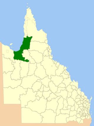
The Shire of Carpentaria is a local government area in Far North Queensland, Australia on the Gulf of Carpentaria, for which it is named.

<span class="mw-page-title-main">Shire of Cook</span> Local government area in Queensland, Australia

The Shire of Cook is a local government area in Far North Queensland, Australia. The Shire covers most of the eastern and central parts of Cape York Peninsula, the most northerly section of the Australian mainland.

<span class="mw-page-title-main">Shire of Torres</span> Local government area in Queensland, Australia

The Shire of Torres is a local government area located in Far North Queensland, Australia, covering large sections of the Torres Strait Islands and the northern tip of Cape York Peninsula north of 11°S latitude. It holds two distinctions—it is the northernmost Local Government Area in Australia, and is the only one to abut an international border – it is at one point just 73 kilometres (45 mi) from Papua New Guinea. It is administered from Thursday Island.

<span class="mw-page-title-main">Shire of Mornington (Queensland)</span> Local government area in Queensland, Australia

The Shire of Mornington is a local government area in northwestern Queensland, Australia. The shire covers the Wellesley Islands, which includes Mornington Island; the South Wellesley Islands; Bountiful Islands; and West Wellesley / Forsyth Islands groups in the Gulf of Carpentaria.

<span class="mw-page-title-main">Aboriginal Shire of Palm Island</span> Local government area in Queensland, Australia

The Aboriginal Shire of Palm Island is a special local government area of Queensland, Australia, managed by the Palm Island Aboriginal Shire Council under a Deed of Grant in Trust granted to the community on 27 October 1986. The local council was previously the Palm Island Community Council, which had far fewer powers. The shire is located on the Palm Island group, off the north Queensland coast near the city of Townsville.

<span class="mw-page-title-main">Aboriginal Shire of Doomadgee</span> Local government area in Queensland, Australia

The Aboriginal Shire of Doomadgee is a special local government area in North West Queensland, Queensland, Australia. It is managed under a Deed of Grant in Trust under the Local Government Act 2004.

<span class="mw-page-title-main">Isaac Region</span> Local government area in Queensland, Australia

The Isaac Region is a local government area located in Central Queensland, Queensland, Australia created in March 2008 as a result of the report of the Local Government Reform Commission released in July 2007.

<span class="mw-page-title-main">Charters Towers Region</span> Local government area in Queensland, Australia

The Charters Towers Region is a local government area in North Queensland, Australia southwest of, and inland from the city of Townsville, based in Charters Towers. Established in 2008, it was preceded by two previous local government areas which dated back to the 1870s.

<span class="mw-page-title-main">Cairns Region</span> Local government area of Queensland, Australia

The Cairns Region is a local government area in Far North Queensland, Queensland, Australia, centred on the regional city of Cairns. It was established in 2008 by the amalgamation of the City of Cairns and the Shires of Douglas and Mulgrave. However, following public protest and a referendum in 2013, on 1 January 2014, the Shire of Douglas was de-amalgamated from the Cairns Region and re-established as a separate local government authority.

<span class="mw-page-title-main">Northern Peninsula Area Region</span> Local government area in Queensland, Australia

The Northern Peninsula Area Region is a local government area in Far North Queensland, Australia, covering areas on the northwestern coast of Cape York Peninsula. It was created in March 2008 out of three Aboriginal Shires and two autonomous Island Councils during a period of statewide local government reform. In June 2018, the area had a population of 3,069.

The Torres Strait Island Region is a local government area in Far North Queensland, Australia, covering part of the Torres Strait Islands. It was created in March 2008 out of 15 autonomous Island Councils during a period of statewide local government reform. It has offices in each of its 15 communities, and satellite services in Thursday Island and in Cairns.

<span class="mw-page-title-main">Aboriginal Shire of Kowanyama</span> Local government area in Queensland, Australia

The Aboriginal Shire of Kowanyama is a special local government area which is located on western Cape York Peninsula in Queensland, Australia. It is managed under a Deed of Grant in Trust under the Local Government Act 2004.

<span class="mw-page-title-main">Aboriginal Shire of Yarrabah</span> Local government area in Queensland, Australia

The Aboriginal Shire of Yarrabah is a special local government area in Far North Queensland, Queensland, Australia, east and southeast of Cairns on Cape Grafton. It is managed under a Deed of Grant in Trust under the Local Government Act 2004.

<span class="mw-page-title-main">Aboriginal Shire of Hope Vale</span> Local government area in Queensland, Australia

The Aboriginal Shire of Hope Vale is a local government area in Far North Queensland, Queensland, Australia, north of the town of Cooktown. The majority of the Shire consists of Deed of Grant land that is held for the benefit of Aboriginal people particularly concerned with the land and their ancestors and descendants.

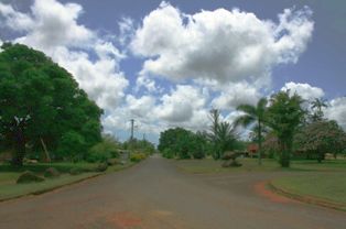
Edward River is a rural locality in the Shire of Cook, Queensland, Australia. In the 2016 census Edward River had a population of 0 people.

References

  1. 1 2 "3218.0 – Regional Population Growth, Australia, 2017-18: Population Estimates by Local Government Area (ASGS 2018), 2017 to 2018". Australian Bureau of Statistics. Australian Bureau of Statistics. 27 March 2019. Archived from the original on 27 March 2019. Retrieved 25 October 2019. Estimated resident population, 30 June 2018.
  2. "Kuuk Thaayorre". State Library of Queensland. Archived from the original on 23 April 2021. Retrieved 30 January 2020.
  3. "Pormpuraaw Aboriginal Shire Council". Public Libraries Connect. State Library of Queensland. 20 September 2016. Archived from the original on 5 February 2018. Retrieved 4 February 2018.
  4. CC BY icon.svg This Wikipedia article incorporates text from Pormpuraaw Indigenous Knowledge Centre (25 November 2022) by Indigenous Services published by the State Library of Queensland under CC-BY licence , accessed on 19 January 2023.
  5. "2008 Pormpuraaw Aboriginal Shire Council - Mayoral Election - Election Summary". results.ecq.qld.gov.au. Archived from the original on 7 April 2019. Retrieved 4 December 2017.
  6. "2012 Pormpuraaw Aboriginal Shire Council - Mayoral Election - Election Summary". results.ecq.qld.gov.au. Archived from the original on 5 April 2018. Retrieved 4 December 2017.
  7. "2016 Pormpuraaw Aboriginal Shire Council - Mayoral Election - Election Summary". results.ecq.qld.gov.au. Archived from the original on 27 March 2018. Retrieved 4 December 2017.
  8. "Elected Council". Pormpuraaw Aboriginal Shire Council. Archived from the original on 8 March 2019. Retrieved 16 May 2019.
  9. 1 2 "2020 Local Government Elections: Saturday, 28 March 2020". Electoral Commission of Queensland. 2020. Retrieved 16 June 2020.[ dead link ]

Coordinates: 14°53′53.28″S141°37′10.08″E / 14.8981333°S 141.6194667°E / -14.8981333; 141.6194667