
The Shire of Aurukun is a local government area in Far North Queensland, Australia. The shire covers part of western Cape York Peninsula, the most northerly section of the Australian mainland.

Lockhart River is a town in the Aboriginal Shire of Lockhart River and a coastal locality split between the Aboriginal Shire of Lockhart River and the Shire of Cook, on the Cape York Peninsula in Queensland, Australia. In the 2016 census, Lockhart River had a population of 724 people.

The Shire of Mckinlay is a local government area in north-western Queensland, Australia.

The Shire of Richmond is a local government area in north western Queensland, Australia.

The Shire of Flinders is a local government area in north-western Queensland, Australia.

The Shire of Douglas is a local government area in Far North Queensland. It is located on the coast north of the city of Cairns. The shire, administered from the town of Mossman, covers an area of 2,428 square kilometres (937.5 sq mi), and existed as a local government entity from 1880 until 2008, when it was amalgamated with the City of Cairns to become the Cairns Region. Following a poll in 2013, the Shire of Douglas was re-established on 1 January 2014.
The Shire of Carpentaria is a local government area in Far North Queensland, Australia on the Gulf of Carpentaria, for which it is named.

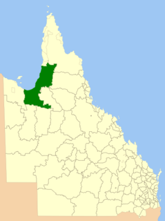
The Shire of Cook is a local government area in Far North Queensland, Australia. The Shire covers most of the eastern and central parts of Cape York Peninsula, the most northerly section of the Australian mainland.

The Shire of Mornington is a local government area in north-west Queensland, Australia. The Shire covers Mornington Island and neighbouring islands in the Wellesley Islands group in the Gulf of Carpentaria. The Shire Council employees are 93% local indigenous residents.

The Aboriginal Shire of Doomadgee is a special local government area in North West Queensland, Queensland, Australia. It is managed under a Deed of Grant in Trust under the Local Government Act 2004.

The Moreton Bay Region is a local government area in the north of the Brisbane metropolitan area in South East Queensland, Australia. Established in 2008, it replaced three established local government areas, the City of Redcliffe and the Shires of Pine Rivers and Caboolture.
The Cairns Region is a local government area in Far North Queensland, Queensland, Australia, centred on the regional centre of Cairns. It was established in 2008 by the amalgamation of the City of Cairns and the Shire of Douglas. However, following public protest and a referendum in 2013, on 1 January 2014, the Shire of Douglas was separated from the Cairns Region and re-established as a local government authority.

The Northern Peninsula Area Region is a local government area in Far North Queensland, Australia, covering areas on the northwestern coast of Cape York Peninsula. It was created in March 2008 out of three Aboriginal Shires and two autonomous Island Councils during a period of statewide local government reform. In June 2018, the area had a population of 3,069.

The Aboriginal Shire of Kowanyama is a special local government area which is located on western Cape York Peninsula in Queensland, Australia. It is managed under a Deed of Grant in Trust under the Local Government Act 2004.

The Aboriginal Shire of Woorabinda is a local government area in Central Queensland, Australia.

The Aboriginal Shire of Pormpuraaw is a special local government area which is located on western Cape York Peninsula in Queensland, Australia. It is managed under a Deed of Grant in Trust under the Local Government Act 2004.
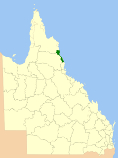
The Wujal Wujal Aboriginal Shire is a local government area in Far North Queensland, Australia. It is managed as a Deed of Grant in Trust under the Local Government Act 2004.

The Aboriginal Shire of Hope Vale is a local government area in Far North Queensland, Queensland, Australia, north of the town of Cooktown. The majority of the Shire consists of Deed of Grant land that is held for the benefit of Aboriginal people particularly concerned with the land and their ancestors and descendants.
The Aboriginal Shire of Mapoon is a local government area in Far North Queensland, Australia. It is on the western coast of Cape York Peninsula on the Gulf of Carpentaria.

The Aboriginal Shire of Napranum is a local government area in Far North Queensland, Australia. It is on the western side of the Cape York Peninsula around Weipa.
