Isaac Region

Last updated

Isaac Region
Queensland
Isaac LGA Qld 2008.png
Location within Queensland
Population20,934 (2018) [1]
 • Density0.356578/km2 (0.923534/sq mi)
Established2008
Area58,708 km2 (22,667.3 sq mi) [1]
MayorAnne Baker
Council seat Moranbah
State electorate(s)
Federal division(s) Capricornia
Issac regional council logo.svg
Website Isaac Region
LGAs around Isaac Region:
Charters Towers Whitsunday Mackay
Barcaldine Isaac Region Coral Sea
Barcaldine Central Highlands Livingstone

The Isaac Region is a local government area located in Central Queensland, Queensland, Australia created in March 2008 as a result of the report of the Local Government Reform Commission released in July 2007.

Contents

History

Yagalingu is an Australian Aboriginal language of Central Queensland. Its traditional language region was within the local government area of Isaac Region, from the headwaters of the Belyando River south to Avoca, north to Laglan, west to the Great Dividing Range, and east and south to Drummond Range. [2]

Prior to 2008, the Isaac Region was an entire area of three previous and distinct local government areas:

The report recommended that the new local government area should not be divided into wards and should elect eight councillors and a mayor. The Isaac Regional Council covers an area of 58,708 square kilometres (22,667 sq mi), [1] had a population in 2018 of 20,934 [1] and an operating budget of A$46.0m.

The region takes its name from the Isaac River, which in turn takes its name from Queensland pioneer Frederick Isaac who accompanied the explorer Ludwig Leichhardt on his first expedition. [3]

Towns and localities

The Isaac Region includes the following settlements:

* - The former town of Blair Athol, obliterated by the Blair Athol coal mine was within the region. [4]

Islands

Isaac also includes several uninhabited islands, including the Flat Isles, with Avoid Island, which is an important habitat for the flatback sea turtle. [5]

Libraries

Isaac Regional Council operates public libraries in Carmila, Clermont, Dysart, Glenden, Middlemount, Moranbah, Nebo, and St Lawrence. [6]

Mayors

Population

The populations given relate to the component entities prior to 2008.

YearTotal RegionBelyandoBroadsoundNebo
19334,9712,9871,590394
19475,0163,0671,415534
19545,0883,1041,537447
19615,3673,2531,539575
19665,1012,9971,625479
19717,2004,8341,589777
197611,3897,2103,379800
198115,5227,7006,908914
198622,13311,3628,4192,352
199122,18811,0828,4722,634
199620,70310,7557,4862,462
200119,0139,8836,6012,529
200619,82010,4556,8432,522
201620,940

Related Research Articles

<span class="mw-page-title-main">Shire of Peak Downs</span> Local government area in Queensland, Australia

The Shire of Peak Downs was a local government area in the Central Highlands of Queensland, Australia, 320 km west of both Rockhampton and Mackay. On 15 March 2008 the shires of Duaringa, Emerald, Bauhinia and Peak Downs were amalgamated to form the Central Highlands Region.

<span class="mw-page-title-main">Shire of Belyando</span> Local government area in Queensland, Australia

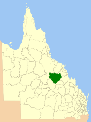
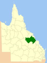
The Shire of Belyando was a local government area in Central Queensland, Australia. The Shire, administered from the town of Clermont, covered an area of 30,281.3 square kilometres (11,691.7 sq mi), and existed as a local government entity from 1879 until 2008, when it was amalgamated with the Shires of Broadsound and Nebo to form the Isaac Region.

<span class="mw-page-title-main">Shire of Nebo</span> Local government area in Queensland, Australia

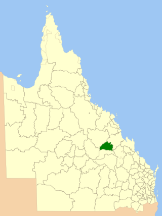
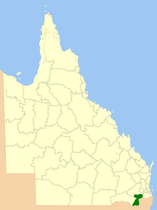
The Shire of Nebo was a local government area in Central Queensland, Queensland, Australia, about 80 kilometres (50 mi) south-west of the regional city of Mackay. The Shire, administered from the town of Nebo, covered an area of 10,034.6 square kilometres (3,874.4 sq mi), and existed as a local government entity from 1883 until 2008, when it was amalgamated with the Shires of Belyando and Broadsound to form the Isaac Region.

<span class="mw-page-title-main">Shire of Croydon</span> Local government area in Queensland, Australia

The Shire of Croydon is a local government area in western Queensland, Australia. The shire, administered from the town of Croydon, covers an area of 29,498 square kilometres (11,389.2 sq mi). The council consists of a mayor plus four councillors, each of whom represents the entire Shire.

<span class="mw-page-title-main">Shire of Torres</span> Local government area in Queensland, Australia

The Shire of Torres is a local government area located in Far North Queensland, Australia, covering large sections of the Torres Strait Islands and the northern tip of Cape York Peninsula north of 11°S latitude. It holds two distinctions—it is the northernmost Local Government Area in Australia, and is the only one to abut an international border – it is at one point just 73 kilometres (45 mi) from Papua New Guinea. It is administered from Thursday Island.

<span class="mw-page-title-main">Aboriginal Shire of Doomadgee</span> Local government area in Queensland, Australia

The Aboriginal Shire of Doomadgee is a special local government area in North West Queensland, Queensland, Australia. It is managed under a Deed of Grant in Trust under the Local Government Act 2004.

<span class="mw-page-title-main">North Burnett Region</span> Local government area in Queensland, Australia

The North Burnett Region is a local government area in Queensland, Australia in the northern catchment of the Burnett River. Established in 2008, it was preceded by several previous local government areas with histories extending back to the early 1900s.

<span class="mw-page-title-main">Maranoa Region</span> Local government area in Queensland, Australia

Maranoa Region is a local government area in South West Queensland, Australia. The town of Roma is the administrative headquarters of the region.

<span class="mw-page-title-main">Central Highlands Region</span> Local government area in Queensland, Australia

Central Highlands Region is a local government area in Queensland, Australia.

<span class="mw-page-title-main">Cassowary Coast Region</span> Local government area in Queensland, Australia

The Cassowary Coast Region is a local government area in the Far North Queensland region of Queensland, Australia, south of Cairns and centred on the towns of Innisfail, Cardwell and Tully. It was created in 2008 from a merger of the Shire of Cardwell and the Shire of Johnstone.

<span class="mw-page-title-main">Tablelands Region</span> Local government area in Queensland, Australia

The Tablelands Region is a local government area in Far North Queensland, Australia inland from the city of Cairns. Established in 2008, it was preceded by four previous local government areas which dated back more than a century. On 1 January 2014, one of those local government areas, the Shire of Mareeba, was re-established independent of the Tablelands Region.

<span class="mw-page-title-main">Blackall-Tambo Region</span> Local government area in Queensland, Australia

The Blackall-Tambo Region is a local government area in Central West Queensland, Australia. Established in 2008, it was preceded by two previous local government areas dating from the 1870s.

<span class="mw-page-title-main">Toowoomba Region</span> Local government area in Queensland, Australia

The Toowoomba Region is a local government area located in the Darling Downs part of Queensland, Australia. Established in 2008, it was preceded by several previous local government areas with histories extending back to the early 1900s and beyond.

<span class="mw-page-title-main">Charters Towers Region</span> Local government area in Queensland, Australia

The Charters Towers Region is a local government area in North Queensland, Australia southwest of, and inland from the city of Townsville, based in Charters Towers. Established in 2008, it was preceded by two previous local government areas which dated back to the 1870s.

<span class="mw-page-title-main">Fraser Coast Region</span> Local government area in Queensland, Australia

The Fraser Coast Region is a local government area in the Wide Bay–Burnett region of Queensland, Australia, about 250 kilometres (160 mi) north of Brisbane, the state capital. It is centred on the twin cities of Hervey Bay and Maryborough and also contains K'gari. It was created in 2008 from a merger of the Cities of Maryborough and Hervey Bay and the Shires of Woocoo and most of Tiaro. In June 2018 it had a population of 105,463.

<span class="mw-page-title-main">Southern Downs Region</span> Local government area in Queensland, Australia

The Southern Downs Region is a local government area in the Darling Downs region of Queensland, Australia, along the state's boundary with New South Wales. It was created in 2008 from a merger of the Shire of Warwick and the Shire of Stanthorpe.

<span class="mw-page-title-main">Whitsunday Region</span> Local government area in Queensland, Australia

The Whitsunday Region is a local government area located in North Queensland, Australia. Established in 2008, it was preceded by two previous local government areas with a history extending back to the establishment of regional local government in Queensland in 1879.

<span class="mw-page-title-main">Gympie Region</span> Local government area in Queensland, Australia

The Gympie Region is a local government area in the Wide Bay–Burnett region of Queensland, Australia, about 170 kilometres (110 mi) north of Brisbane, the state capital. It is between the Sunshine Coast and Hervey Bay and centred on the town of Gympie. It was created in 2008 from a merger of the Shires of Cooloola and Kilkivan and part of the Shire of Tiaro.

<span class="mw-page-title-main">Aboriginal Shire of Pormpuraaw</span> Local government area in Queensland, Australia

The Aboriginal Shire of Pormpuraaw is a special local government area which is located on western Cape York Peninsula in Queensland, Australia. It is managed under a Deed of Grant in Trust under the Local Government Act 2004.

<span class="mw-page-title-main">Aboriginal Shire of Yarrabah</span> Local government area in Queensland, Australia

The Aboriginal Shire of Yarrabah is a special local government area in Far North Queensland, Queensland, Australia, east and southeast of Cairns on Cape Grafton. It is managed under a Deed of Grant in Trust under the Local Government Act 2004.

References

  1. 1 2 3 4 "3218.0 – Regional Population Growth, Australia, 2017-18: Population Estimates by Local Government Area (ASGS 2018), 2017 to 2018". Australian Bureau of Statistics. Australian Bureau of Statistics. 27 March 2019. Retrieved 25 October 2019. Estimated resident population, 30 June 2018.
  2. CC BY icon-80x15.png This Wikipedia article incorporates CC-BY-4.0 licensed text from: "Yagalingu". Queensland Aboriginal and Torres Strait Islander languages map. State Library of Queensland . Retrieved 30 January 2020.
  3. "Isaac Regional Council". Queensland Places. Centre for the Government of Queensland, University of Queensland. Archived from the original on 11 April 2015. Retrieved 5 April 2015.
  4. "Blair Athol". Queensland Places. Centre for the Government of Queensland, University of Queensland. Archived from the original on 24 April 2014. Retrieved 23 April 2014.
  5. "Avoid Island Nature Refuge". Wetland Info. Queensland Government . Retrieved 2 March 2022.
  6. "Find your local library". Isaac Regional Council . Archived from the original on 31 January 2018. Retrieved 31 January 2018.
  7. "2008 Isaac Regional Council - Mayoral Election - Election Summary". results.ecq.qld.gov.au. Archived from the original on 27 April 2018. Retrieved 4 December 2017.
  8. "2012 Isaac Regional Council - Mayoral Election - Election Summary". results.ecq.qld.gov.au. Archived from the original on 1 April 2018. Retrieved 4 December 2017.
  9. "2016 Isaac Regional Council - Mayoral Election - Election Summary". results.ecq.qld.gov.au. Archived from the original on 27 March 2018. Retrieved 4 December 2017.
  10. "2020 Local Government Elections: Saturday, 28 March 2020". Electoral Commission of Queensland. 2020. Retrieved 16 June 2020.[ dead link ]
  11. Gregg, Fergus (13 February 2024). "Isaac council election: Mayor decided, fight for councillor positions". The Daily Mercury. Retrieved 6 April 2024. The next mayor of Isaac Regional Council is already locked in with only incumbent councillor Kelly Vea Vea signing up for the gig.

22°49′00″S148°41′56″E / 22.81667°S 148.69889°E / -22.81667; 148.69889