Rannes, Queensland

Last updated

Rannes
Queensland
Township of Rannes, 1923.jpg
Township of Rannes, 1923
Australia Queensland location map.svg
Red pog.svg
Rannes
Coordinates 24°05′55″S150°07′12″E / 24.0986°S 150.12°E / -24.0986; 150.12 (Rannes (town centre)) Coordinates: 24°05′55″S150°07′12″E / 24.0986°S 150.12°E / -24.0986; 150.12 (Rannes (town centre))
Postcode(s) 4702
Time zone AEST (UTC+10:00)
Location
LGA(s) Shire of Banana
State electorate(s) Fitzroy
Federal division(s) Flynn

Rannes is a rural town in the west of the locality of Goovigen in the Shire of Banana, Queensland, Australia. [1] [2]

Contents

Geography

Rannes is in Central Queensland between Wowan and Banana on the Leichhardt Highway and the Don River. [2]

History

Rannes was established as a pastoral sheep station property in April 1853 by Scottish brothers James, Norman and Charles Leith Hay. The brothers were the offspring of Peninsula War veteran Andrew Leith Hay and the grandsons of General Alexander Leith Hay of Leith Hall. They were the first Europeans to occupy the region and at that time Rannes was the northern-most outpost of British colonisation in Eastern Australia. The brothers named the property Rannes after a Leith Hay family manor house located near Buckie in Scotland. [3] [4]

On 11 May 1853, James Leith Hay sent a letter to Lieutenant John Murray, reporting that two of his shepherds had been murdered by Aborigine men and requested the services of the Native Police. On 16 May, Murray and a section of troopers arrived at Rannes Station. Two days later, Murray went in search for those responsible. In November 1853, James Leith Hay requested a section of Native Police be posted permanently at Rannes after two men were killed and one hundred sheep stolen. A sort of peace ensued and some of the local tribes were allowed onto the property. On the night of 23 September 1855, the Native Police barracks at Rannes was attacked by a large number of Aboriginal men, killing three troopers and leaving all but one wounded. Murray then led the Native Police and pursued Aborigines "who had taken forcible possession of a station and were prevented from murdering the inhabitants by the timely arrival of the troopers." Sub-Lieutenant Walker also led a patrol to search for the murderers but did not find them. [5]

The town of Rannes was surveyed by surveyor A.F. Wood in July 1860 and the town reserve was gazetted 2 October 1860 (page 396). [1]

Shire Council building, Rannes, circa 1930 StateLibQld 1 105260 Shire Council building, Rannes, ca. 1930.jpg
Shire Council building, Rannes, circa 1930

Rannes was once a major railway town at the junction of the Dawson Valley railway line and the Callide Valley railway line. [6] Both railway lines having been abandoned, the Rannes railway station is no longer extant ( 24°06′13″S150°07′06″E / 24.1035°S 150.1182°E / -24.1035; 150.1182 (Rannes railway station (former)) ). [7]

In 1880, the local government area Banana Division (later the Shire of Banana) was established with its headquarters in Banana (taking its name from the town). However, in 1930 the shire headquarters became Rannes and the shire offices were physically relocated from Banana to Rannes. Since 1946, the shire has its headquarters in Biloela. [8]

Rannes railway station, circa 1940s Railway Station at Rannes, Queensland - circa 1940s.jpg
Rannes railway station, circa 1940s

Rannes railway station was originally named Kuyul, but was changed 29 April 1915. [1]

Rannes State School opened on 14 March 1916. It closed on 23 February 1960 but reopened on 30 January 1962. It closed permanently on 18 March 1966. [9]

Woolein State School opened on 27 February 1918 and closed on 17 August 1924. [9]

Economy

Rannes is primarily a farming town which specialises in the beef and grain industry.

Education

There are no schools in Rannes. The nearest government primary school is Goovigen State School in the town of Goovigen to the east. The nearest government secondary schools are Baralaba State School (to Year 10) in Baralaba to the west and Biloela State High School (to Year 12) in Biloela to the south-east. [2]

Related Research Articles

<span class="mw-page-title-main">Biloela</span> Town in Queensland, Australia

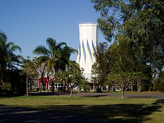
Biloela is a rural town and locality in Shire of Banana, Central Queensland, Australia. It is situated 120 kilometres (75 mi) inland from the port city of Gladstone at the junction of the Burnett and Dawson highways. Biloela is the administrative centre of Banana Shire, which has an area of 15,729 square kilometres (6,073 sq mi). In the 2021 census, the locality of Biloela had a population of 5,692 people.

<span class="mw-page-title-main">Banana, Queensland</span> Town in Queensland, Australia

Banana is a rural town and locality in the Shire of Banana, Queensland, Australia. In the 2016 census, the locality of Banana had a population of 356 people.

<span class="mw-page-title-main">Mount Larcom, Queensland</span> Town in Queensland, Australia

Mount Larcom is the name of a mountain, a rural town and locality in the Gladstone Region, Queensland, Australia. In the 2016 census, the locality of Mount Larcom had a population of 361 people.

<span class="mw-page-title-main">Baralaba, Queensland</span> Town in Queensland, Australia

Baralaba is a rural town and locality in the Shire of Banana in central Queensland, Australia. In the 2016 census, Baralaba had a population of 314 people.

<span class="mw-page-title-main">Taroom</span> Town in Queensland, Australia

Taroom is a town in the Shire of Banana and locality split between the Shire of Banana and the Western Downs Region in Queensland, Australia. At the 2016 census, Taroom had a population of 869 people.

<span class="mw-page-title-main">Shire of Banana</span> Local government area in Queensland, Australia

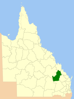
The Shire of Banana is a local government area located in the Capricorn region of Queensland, Australia, inland from the regional city of Gladstone. The shire was named after the first township in the region (Banana), which in turn was named for the burial site of a huge dun coloured bullock named 'Banana'. The council sits in the town of Biloela, which is the largest town in the Shire.

<span class="mw-page-title-main">Australian native police</span> Police units consisting of Australian Aboriginal men

Australian native police units, consisting of Aboriginal troopers under the command (usually) of at least one white officer, existed in various forms in all Australian mainland colonies during the nineteenth and, in some cases, into the twentieth centuries. The Native Mounted Police utilised horses as their transportation mode in the days before motor cars, and patrolled huge geographic areas. The introduction of a Police presence helped provide law & order to areas which were already struggling with crime issues. From established base camps they patrolled vast areas to investigate law breaches, including alleged murders. Often armed with rifles, carbines and swords, they sometimes also escorted surveying groups, pastoralists and prospectors through country considered to be dangerous.

<span class="mw-page-title-main">Thangool</span> Town in Queensland, Australia

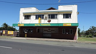
Thangool is a rural town and locality in the Shire of Banana, Queensland, Australia. In the 2016 census the locality of Thangool had a population of 741 people.

<span class="mw-page-title-main">Goovigen</span> Town in Queensland, Australia

Goovigen is a rural town and locality in the Shire of Banana, Queensland, Australia. In the 2016 census, the locality of Goovigen had a population of 215 people.

<span class="mw-page-title-main">Wowan, Queensland</span> Town in Queensland, Australia

Wowan is a rural town and locality in the Shire of Banana, Queensland, Australia. In the 2016 census, the locality of Wowan had a population of 216 people.

<span class="mw-page-title-main">Dawson Valley (Theodore) railway line</span>

The Dawson Valley Branch Railway was a railway line in Central Queensland, Australia. It branched from the Central Western railway line at Kabra in the Rockhampton Region and went to Theodore in the Shire of Banana. It opened in a series of sections between 1898 and 1927, and featured a rack railway section, one of only 3 such systems in Australia.

<span class="mw-page-title-main">Moura railway line</span>

The Moura railway line is a railway in central Queensland, connecting several coal mines to the port of Gladstone. It connects the remnants of several lines that previously connected to Rockhampton, originally by a rack railway.

Callide is a rural town and locality in the Shire of Banana, Queensland, Australia. In the 2016 census, the locality of Callide had a population of 86 people.

Greycliffe is a rural locality in the Shire of Banana, Queensland, Australia. In the 2016 census, Greycliffe had a population of 22 people.

Kokotungo is a rural locality in the Shire of Banana, Queensland, Australia. In the 2016 census Kokotungo had a population of 100 people.

<span class="mw-page-title-main">John Murray (native police officer)</span> Scottish officer in the Australian native police

John Murray was a Scottish officer in the Australian native police in the British colonies of New South Wales and Queensland. He was an integral part of this paramilitary force for nearly twenty years, supporting European colonisation in south-eastern, central and northern Queensland. He also had an important role in recruiting troopers for the Native Police from the Riverina District in New South Wales.

Woolein is a rural locality in the Shire of Banana, Queensland, Australia. In the 2016 census, Woolein had a population of 7 people.

<span class="mw-page-title-main">Lawgi Dawes</span> Suburb of Shire of Banana, Queensland, Australia

Lawgi Dawes is a rural locality in the Shire of Banana, Queensland, Australia. In the 2016 census Lawgi Dawes had a population of 144 people. It contains the neighbourhood of Lawgi, a former town.

Dakenba is a rural locality in the Shire of Banana, Queensland, Australia. In the 2016 census, Dakenba had a population of 116 people.

Alberta is a rural locality in the Shire of Banana, Queensland, Australia. In the 2016 census, Alberta had a population of 69 people.

References

  1. 1 2 3 "Rannes – town in Shire of Banana (entry 28011)". Queensland Place Names. Queensland Government . Retrieved 26 December 2020.
  2. 1 2 3 "Queensland Globe". State of Queensland . Retrieved 25 November 2022.
  3. "Early Settlers: THE LEITH-HAYS AND RANNES STATION". The Central Queensland Herald . Vol. 19, no. 1060. Queensland, Australia. 14 July 1949. p. 3. Retrieved 25 October 2020 via National Library of Australia.
  4. "Queensland". Leith-Hay. Retrieved 24 October 2020.
  5. Skinner, Leslie Edward (1 January 1975), Police of the pastoral frontier : native police, 1849-1859, University of Queensland Press, retrieved 25 October 2020
  6. "Baralaba History Loop" (PDF). Sandstone Wonders. p. 2. Retrieved 24 November 2022.
  7. "Railway stations and sidings - Queensland". Queensland Open Data. Queensland Government. 2 October 2020. Archived from the original on 5 October 2020. Retrieved 5 October 2020.
  8. "Banana Shire". Queensland Places. Centre for the Government of Queensland, University of Queensland. Retrieved 7 June 2014.
  9. 1 2 Queensland Family History Society (2010), Queensland schools past and present (Version 1.01 ed.), Queensland Family History Society, ISBN   978-1-921171-26-0

Further reading