
Westwood is a town in the Rockhampton Region and a locality split between the Rockhampton Region and the Shire of Banana in Queensland, Australia. It was the first town that was gazetted by the Queensland Government. In the 2021 census, the locality of Westwood had a population of 199 people.

Kinka Beach is a coastal rural locality in the Livingstone Shire, Queensland, Australia. In the 2021 census, Kinka Beach had a population of 674 people.
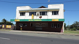
Thangool is a rural town and locality in the Shire of Banana, Queensland, Australia. In the 2021 census, the locality of Thangool had a population of 685 people.

Goovigen is a rural town and locality in the Shire of Banana, Queensland, Australia. In the 2021 census, the locality of Goovigen had a population of 349 people.
Comet is a historically-rich rural town and locality in the Central Highlands Region, Queensland, Australia. In the 2021 census, the locality of Comet had a population of 360 people.

Wowan is a rural town and locality in the Shire of Banana, Queensland, Australia. In the 2021 census, the locality of Wowan had a population of 170 people.

Rannes is a rural town in the west of the locality of Goovigen in the Shire of Banana, Queensland, Australia.

Ravenswood is a rural town and locality in the Charters Towers Region, Queensland, Australia. In the 2021 census, the locality of Ravenswood had a population of 297 people.

Jambin is a rural town and locality in the Shire of Banana, Queensland, Australia. In the 2021 census, the locality of Jambin had a population of 207 people.
Koumala is a rural town and coastal locality in the Mackay Region, Queensland, Australia. In the 2021 census, the locality of Koumala had a population of 772 people.

Mount Chalmers is a rural town and locality in the Livingstone Shire, Queensland, Australia. In the 2021 census, the locality of Mount Chalmers had a population of 226 people.

The Caves is a rural town and locality in the Livingstone Shire, Queensland, Australia. In the 2021 census, the locality of The Caves had a population of 680 people.
Prospect is a rural locality in the Shire of Banana, Queensland, Australia. In the 2021 census, Prospect had a population of 289 people.

Lawgi Dawes is a rural locality in the Shire of Banana, Queensland, Australia. It contains the neighbourhood of Lawgi, a former town.
Dixalea is a rural locality in the Shire of Banana, Queensland, Australia. In the 2021 census, Dixalea had a population of 102 people.
Ulogie is a rural locality in the Shire of Banana, Queensland, Australia. In the 2021 census, Ulogie had a population of 31 people.

Thompson Point is a coastal locality in the Livingstone Shire, Queensland, Australia. It was the site of a short-lived town and port called Broadmount. In the 2021 census, Thompson Point had "no people or a very low population".
Orange Creek is a rural locality in the Shire of Banana, Queensland, Australia. In the 2021 census, Orange Creek had a population of 197 people.

Kianga is a rural locality in the Shire of Banana, Queensland, Australia. In the 2021 census, Kianga had a population of 219 people.
Wura is a rural locality in the Rockhampton Region, Queensland, Australia. In the 2021 census, Wura had "no people or a very low population".


