Cockatoo, Queensland

Last updated

Cockatoo
Queensland
W B Slade and an aboriginal stable boy on Cockatoo Creek Station Queensland 1866.JPG
W B Slade and an aboriginal stable boy on Cockatoo Creek Station, 1866
Australia Queensland location map.svg
Red pog.svg
Cockatoo
Coordinates 25°41′04″S150°16′53″E / 25.6844°S 150.2813°E / -25.6844; 150.2813 (Cockatoo (centre of locality)) Coordinates: 25°41′04″S150°16′53″E / 25.6844°S 150.2813°E / -25.6844; 150.2813 (Cockatoo (centre of locality))
Population36 (2016 census) [1]
 • Density0.0454/km2 (0.1177/sq mi)
Postcode(s) 4419
Area792.5 km2 (306.0 sq mi)
Time zone AEST (UTC+10:00)
Location
LGA(s) Shire of Banana
State electorate(s) Callide
Federal Division(s) Flynn
Suburbs around Cockatoo:
Glebe Cracow Eidsvold West
Taroom Cockatoo Sujeewong
Taroom Bungaban Sujeewong

Cockatoo is a rural locality in the Shire of Banana, Queensland, Australia. [2] In the 2016 census Cockatoo had a population of 36 people. [1]

Contents

Geography

Cockatoo Creek flows through Cockatoo from east to west, eventually flowing to the Dawson River at 25°28′00″S150°02′00″E / 25.4666°S 150.0333°E / -25.4666; 150.0333 (Cockatoo Creek) . [3] [4]

History

Cockatoo State School opened on 23 January 1984 and closed on 31 December 2000. [5] It was located in the south of Cockatoo on Pine Creek Road, possibly just over the border into present-day neighbouring Bungaban at 25°47′22″S150°15′39″E / 25.7895°S 150.2607°E / -25.7895; 150.2607 (Cockatoo State School) .

In the 2011 census, the population of Cockatoo was not separately reported but was included within neighbouring Taroom which had a combined population of 873 people. [6]

In the 2016 census Cockatoo had a population of 36 people. [1]

Education

There are no schools in Cockatoo. The nearest school is Taroom State School in Taroom to the west which is a primary and secondary school to Year 10. There is no nearby secondary school to Year 12; distance education and boarding school are the alternatives. [3]

Notable people

Related Research Articles

Banana, Queensland Town in Queensland, Australia

Banana is a small town and rural locality in the Shire of Banana, Central Queensland, Australia.

Woorabinda, Queensland Town in Queensland, Australia

Woorabinda is a rural town and locality in the Aboriginal Shire of Woorabinda, Queensland, Australia. In the 2016 census, Woorabinda had a population of 962 people. It is an Aboriginal community.

Taroom Town in Queensland, Australia

Taroom is a town in the Shire of Banana and locality split between the Shire of Banana and the Western Downs Region in Queensland, Australia. At the 2016 census, Taroom had a population of 869 people.

Shire of Banana Local government area in Queensland, Australia

The Shire of Banana is a local government area located in the Capricorn region of Queensland, Australia, inland from the regional city of Gladstone. The shire was named after the first township in the region (Banana), which in turn was named for the burial site of a huge dun coloured bullock named 'Banana'. The council sits in the town of Biloela, which is the largest town in the Shire.

Thangool Town in Queensland, Australia

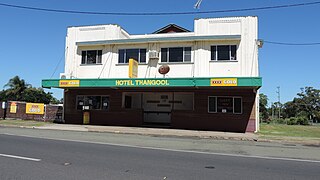
Thangool is a rural town and locality in the Shire of Banana, Queensland, Australia. In the 2016 census the locality of Thangool had a population of 741 people.

Wowan, Queensland Town in Queensland, Australia

Wowan is a rural town and locality in the Shire of Banana, Queensland, Australia. The town of Deeford is also within the locality. In the 2016 census, the locality of Wowan had a population of 216 people.

Jambin, Queensland Town in Queensland, Australia

Jambin is a rural town and locality in the Shire of Banana, Queensland, Australia.

Glebe, Queensland Suburb of Shire of Banana, Queensland, Australia

Glebe is a rural locality in the Shire of Banana, Queensland, Australia. In the 2016 census Glebe had a population of 24 people.

Eurombah, Queensland Suburb of Western Downs Region, Queensland, Australia

Eurombah is a rural locality split between the Western Downs Region and Shire of Banana, Queensland, Australia. The neighbourhoods of Peek-A-Doo and Hornet Bank are within the locality. In the 2016 census, Eurombah had a population of 67 people.

Prospect, Queensland Suburb of Shire of Banana, Queensland, Australia

Prospect is a rural locality in the Shire of Banana, Queensland, Australia. In the 2016 census Prospect had a population of 297 people.

Adelaide Park, Queensland Suburb of Shire of Livingstone, Queensland, Australia

Adelaide Park is a rural locality in the Livingstone Shire, Queensland, Australia. In the 2016 census, Adelaide Park had a population of 424 people.

Columboola, Queensland Town in Queensland, Australia

Columboola is a rural town and locality in the Western Downs Region, Queensland, Australia. In the 2016 census the locality of Columboola had a population of 72 people.

Spring Creek, Queensland (Banana Shire) Suburb of Shire of Banana, Queensland, Australia

Spring Creek is a rural locality in the Shire of Banana, Queensland, Australia. In the 2016 census Spring Creek had a population of 15 people.

Greycliffe, Queensland Suburb of Shire of Banana, Queensland, Australia

Greycliffe is a rural locality in the Shire of Banana, Queensland, Australia. In the 2016 census, Greycliffe had a population of 22 people.

Pheasant Creek, Queensland Suburb of Shire of Banana, Queensland, Australia

Pheasant Creek is a rural locality in the Shire of Banana, Queensland, Australia. In the 2016 census Pheasant Creek had a population of 48 people.

Lawgi Dawes Suburb of Shire of Banana, Queensland, Australia

Lawgi Dawes is a rural locality in the Shire of Banana, Queensland, Australia. In the 2016 census Lawgi Dawes had a population of 144 people. It contains the neighbourhood of Lawgi, a former town.

Dumpy Creek, Queensland Suburb of Shire of Banana, Queensland, Australia

Dumpy Creek is a rural locality in the Shire of Banana, Queensland, Australia. In the 2016 census Dumpy Creek had a population of 11 people.

Orange Creek, Queensland Suburb of Shire of Banana, Queensland, Australia

Orange Creek is a rural locality in the Shire of Banana, Queensland, Australia. In the 2016 census, Orange Creek had a population of 212 people.

Lonesome Creek, Queensland Suburb of Shire of Banana, Queensland, Australia

Lonesome Creek is a rural locality in the Shire of Banana, Queensland, Australia. In the 2016 census, Lonesome Creek had a population of 170 people.

Kinnoul, Queensland Suburb of Shire of Banana, Queensland, Australia

Kinnoul is a rural locality in the Shire of Banana, Queensland, Australia. In the 2016 census Kinnoul had a population of 69 people.

References

  1. 1 2 3 Australian Bureau of Statistics (27 June 2017). "Cockatoo (SSC)". 2016 Census QuickStats. Retrieved 20 October 2018. OOjs UI icon edit-ltr-progressive.svg
  2. "Cockatoo – locality in Shire of Banana (entry 49542)". Queensland Place Names. Queensland Government . Retrieved 26 December 2020.
  3. 1 2 "Queensland Globe". State of Queensland . Retrieved 3 February 2021.
  4. "Cockatoo Creek (entry 7608)". Queensland Place Names. Queensland Government . Retrieved 8 February 2015.
  5. "Opening and closing dates of Queensland Schools". Queensland Government . Retrieved 8 February 2015.
  6. Australian Bureau of Statistics (31 October 2012). "Taroom (SSC)". 2011 Census QuickStats. Retrieved 8 February 2015. OOjs UI icon edit-ltr-progressive.svg
  7. "Florence E. Lord". AustLit . Archived from the original on 8 February 2015. Retrieved 8 February 2015.

Commons-logo.svg Media related to Cockatoo, Queensland at Wikimedia Commons