Mount Murchison, Queensland

Last updated

Mount Murchison
Queensland
Australia Queensland location map.svg
Red pog.svg
Mount Murchison
Coordinates 24°20′09″S150°34′16″E / 24.3358°S 150.5711°E / -24.3358; 150.5711 (Mount Murchison (centre of locality)) Coordinates: 24°20′09″S150°34′16″E / 24.3358°S 150.5711°E / -24.3358; 150.5711 (Mount Murchison (centre of locality))
Population149 (2016 census) [1]
 • Density1.961/km2 (5.078/sq mi)
Postcode(s) 4715 [2]
Area76.0 km2 (29.3 sq mi)
Time zone AEST (UTC+10:00)
Location
LGA(s) Shire of Banana
State electorate(s) Callide
Federal Division(s) Flynn
Suburbs around Mount Murchison:
Callide Dumgree Dumgree
Dakenba Mount Murchison Dumgree
Dakenba Valentine Plains Valentine Plains

Mount Murchison is a rural locality in the Shire of Banana, Queensland, Australia. [3] In the 2016 census Mount Murchison had a population of 149 people. [1]

Contents

History

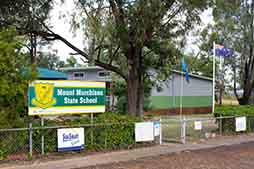
Mount Murchison State School opened on 24 April 1935. [4] [5] The new school was built to cater for up to 24 students with a single 18x18 foot classroom with 8 foot verandas front and rear; it was a timber building with a galvanised iron roof and was built on the property of Mr C. G. Skinner. [6] [7] The teacher was Reg Davidson. [8]

The mobile library service commenced in 2004. [9]

In the 2011 census, Mount Murchison had a population of 226 people. [10]

In the 2016 census Mount Murchison had a population of 149 people. [1]

Education

Mount Murchison State School is a government primary (Prep-6) school for boys and girls at Lot 137 Dawson Highway ( 24°20′02″S150°32′16″E / 24.3338°S 150.5379°E / -24.3338; 150.5379 (Mount Murchison State School) ). [11] [12] In 2013, the school had 16 students in a single multi-age class with one teacher. [13] In 2018, the school had an enrolment of 33 students with 3 teachers and 6 non-teaching staff (2 full-time equivalent). [14]

There is no secondary school in Mount Murchison. The nearest secondary school is Biloela State High School in Biloela to the south-west. [15]

Amenities

Banana Shire Council operate a fortnightly mobile library service to the school. [16] [17]

Related Research Articles

Biloela Town in Queensland, Australia

Biloela is a rural town and locality in Shire of Banana, Central Queensland, Australia. It is situated 120 kilometres (75 mi) inland from the port city of Gladstone at the junction of the Burnett and Dawson highways. Biloela is the administrative centre of Banana Shire, which has an area of 15,729 square kilometres (6,073 sq mi). In the 2016 census, Biloela had a population of 5,758 people.

Mount Morgan, Queensland City in Queensland, Australia

Mount Morgan is a town and locality in Rockhampton Region, Queensland, Australia. The town was the administrative centre of the Mount Morgan Shire until March 2008, when it was amalgamated with neighbouring local government areas to form the Rockhampton Region.

Banana, Queensland Town in Queensland, Australia

Banana is a small town and rural locality in the Shire of Banana, Central Queensland, Australia.

Moura, Queensland Town in Queensland, Australia

Moura is a small town and locality in the Shire of Banana in Central Queensland, Australia. It services the surrounding coal mining and rural activities. It is situated approximately 65 kilometres (40 mi) west of Biloela on the Dawson Highway, 186 kilometres (116 mi) west of the port city of Gladstone, and 171 kilometres (106 mi) south west of Rockhampton.

Westwood, Queensland Town in Queensland, Australia

Westwood is a town in the Rockhampton Region and a locality split between the Rockhampton Region and the Shire of Banana in Queensland, Australia. It was the first town that was gazetted by the Queensland Government. In the 2016 census, Westwood had a population of 174 people.

Theodore, Queensland Town in Queensland, Australia

Theodore is a town and a locality in the Shire of Banana, Queensland, Australia. It was established in the 1920s as part of Queensland Premier Ted Theodore's ambitious Dawson River Irrigation Scheme which failed to eventuate. It was originally known as Castle Creek, but that name is now used by another locality in the area.

Baralaba, Queensland Town in Queensland, Australia

Baralaba is a rural town and locality in the Shire of Banana in central Queensland, Australia. In the 2016 census, Baralaba had a population of 314 people.

Shire of Banana Local government area in Queensland, Australia

The Shire of Banana is a local government area located in the Capricorn region of Queensland, Australia, inland from the regional city of Gladstone. The shire was named after the first township in the region (Banana), which in turn was named for the burial site of a huge dun coloured bullock named 'Banana'. The council sits in the town of Biloela, which is the largest town in the Shire.

Thangool Town in Queensland, Australia

Thangool is a rural town and locality in the Shire of Banana, Queensland, Australia. In the 2016 census the locality of Thangool had a population of 741 people.

Goovigen Town in Queensland, Australia

Goovigen is a rural town and locality in the Shire of Banana, Queensland, Australia. In the 2016 census the locality of Goovigen had a population of 215 people.

Wowan, Queensland Town in Queensland, Australia

Wowan is a rural town and locality in the Shire of Banana, Queensland, Australia. The town of Deeford is also within the locality. In the 2016 census, the locality of Wowan had a population of 216 people.

Jambin, Queensland Town in Queensland, Australia

Jambin is a rural town and locality in the Shire of Banana, Queensland, Australia.

Raglan, Queensland Town in Queensland, Australia

Raglan is a rural town and locality in the Gladstone Region, Queensland, Australia. In the 2016 census the locality of Raglan had a population of 146 people.f>

Bracewell, Queensland Suburb of Gladstone Region, Queensland, Australia

Bracewell is a rural locality in the Gladstone Region, Queensland, Australia. In the 2016 census Bracewell had a population of 196 people.

Gladstone Central Suburb of Gladstone, Queensland, Australia

Gladstone Central is a coastal suburb of Gladstone in the Gladstone Region, Queensland, Australia. It is the historic centre and central business district of the city of Gladstone and the seat of the Gladstone Regional Council.

Bajool, Queensland Suburb of Rockhampton Region, Queensland, Australia

Bajool is a rural town and locality in the Rockhampton Region, Queensland, Australia. In the 2016 census, Bajool had a population of 455 people.

Mount Chalmers, Queensland Town in Queensland, Australia

Mount Chalmers is a rural town and locality in the Livingstone Shire, Queensland, Australia. In the 2016 census the locality of Mount Chalmers had a population of 235 people.

Prospect, Queensland Suburb of Shire of Banana, Queensland, Australia

Prospect is a rural locality in the Shire of Banana, Queensland, Australia. In the 2016 census Prospect had a population of 297 people.

Lakes Creek, Queensland Suburb of Rockhampton Region, Queensland, Australia

Lakes Creek is a suburb split between Rockhampton Region and Shire of Livingstone, Queensland, Australia. In the 2016 census Lakes Creek had a population of 552 people.

Lawgi Dawes Suburb of Shire of Banana, Queensland, Australia

Lawgi Dawes is a rural locality in the Shire of Banana, Queensland, Australia. In the 2016 census Lawgi Dawes had a population of 144 people. It contains the neighbourhood of Lawgi, a former town.

References

  1. 1 2 3 Australian Bureau of Statistics (27 June 2017). "Mount Murchison (SSC)". 2016 Census QuickStats. Retrieved 20 October 2018. OOjs UI icon edit-ltr-progressive.svg
  2. Mount Murchison Postcode Australia Post
  3. "Mount Murchison – locality in Shire of Banana (entry 49565)". Queensland Place Names. Queensland Government . Retrieved 26 December 2020.
  4. "Opening and closing dates of Queensland Schools". Queensland Government . Retrieved 2 July 2014.
  5. "Agency ID 5539, Mount Murchison State School". Queensland State Archives . Retrieved 2 July 2014.
  6. "MT. MURCHISON STATE SCHOOL". The Morning Bulletin . Rockhampton, Qld.: National Library of Australia. 19 July 1934. p. 6. Retrieved 2 July 2014.
  7. "BILOELA". The Morning Bulletin . Rockhampton, Qld.: National Library of Australia. 24 April 1935. p. 7. Retrieved 2 July 2014.
  8. "MURGON". Maryborough Chronicle, Wide Bay and Burnett Advertiser . Qld.: National Library of Australia. 31 December 1935. p. 9. Retrieved 2 July 2014.
  9. "Public Libraries Statistical Bulletin 2016-17" (PDF). Public Libraries Connect. State Library of Queensland. November 2017. p. 11. Archived (PDF) from the original on 30 January 2018. Retrieved 29 January 2018.
  10. Australian Bureau of Statistics (31 October 2012). "Mount Murchison (SSC)". 2011 Census QuickStats. Retrieved 2 July 2014. OOjs UI icon edit-ltr-progressive.svg
  11. "State and non-state school details". Queensland Government. 9 July 2018. Archived from the original on 21 November 2018. Retrieved 21 November 2018.
  12. "Mount Murchison State School" . Retrieved 5 March 2021.
  13. "2013 School Annual Report" (PDF). Mount Murchison State School. Mount Murchison State School. Archived (PDF) from the original on 14 July 2014. Retrieved 2 July 2014.
  14. "ACARA School Profile 2018". Australian Curriculum, Assessment and Reporting Authority. Archived from the original on 27 August 2020. Retrieved 28 January 2020.
  15. "Queensland Globe". State of Queensland . Retrieved 4 March 2021.
  16. "Library: Branches & Opening hours". Banana Shire Council. Archived from the original on 19 March 2017. Retrieved 8 May 2017.
  17. "Banana Shire Mobile Library Timetable" (PDF). Banana Shire Council. Retrieved 8 May 2017.[ permanent dead link ]