Westwood, Queensland

Last updated

Westwood
Queensland
Australia Queensland location map.svg
Red pog.svg
Westwood
Coordinates 23°36′52″S150°09′24″E / 23.6144°S 150.1566°E / -23.6144; 150.1566 Coordinates: 23°36′52″S150°09′24″E / 23.6144°S 150.1566°E / -23.6144; 150.1566
Population174 (2016 census) [1]
 • Density0.3905/km2 (1.0114/sq mi)
Postcode(s) 4702
Area445.6 km2 (172.0 sq mi)
Time zone AEST (UTC+10:00)
Location
LGA(s)
State electorate(s) Fitzroy
Federal division(s) Flynn
Localities around Westwood:
Gogango Wycarbah Bushley
Gogango Westwood Boulder Creek
Oakey Creek
Pheasant Creek Dululu Wura

Westwood is a town in the Rockhampton Region and a locality split between the Rockhampton Region and the Shire of Banana in Queensland, Australia. [2] [3] [4] It was the first town that was gazetted by the Queensland Government. In the 2016 census, Westwood had a population of 174 people. [1]

Contents

Geography

Westwood is 50 kilometres (31 mi) southwest of the city of Rockhampton. The Capricorn Highway passes through the town, and the intersection with the Leichhardt Highway is a few kilometres to the southwest. The town of Westwood consists of a handful of houses, a hotel, and a police station. The major industry of the area is cattle grazing. The northern half of the locality of Westwood is in Rockhampton region while the southern part is in the Shire of Banana. [5]

History

Old Westwood railway station Westwood railway station.tiff
Old Westwood railway station
Westwood School, claimed to be the oldest schoolhouse in Central Queensland, 1930 Westwood School, 1930.tiff
Westwood School, claimed to be the oldest schoolhouse in Central Queensland, 1930
Front and rear views of the new state sanitorium at Westwood, June 1919 Page 26 of the Queenslander Pictorial supplement to The Queenslander 14 June 1919.tiff
Front and rear views of the new state sanitorium at Westwood, June 1919

Although towns such as Brisbane, Maryborough and Rockhampton had been gazetted by the New South Wales Government prior to the separation of Queensland, Westwood was the first town to be gazetted by the newly established Queensland Government on 23 May 1860. Although the area was named Prestone on the original survey plan, Queensland Governor George Bowen decided to name the town Westwood after Westwood House, the home of Sir John Pakington, the Secretary of State for the Colonies and War in 1852. [2] [6]

In 1867, the Great Northern Railway (now known as the Central Western Line) reached the area from Rockhampton, and Westwood became the railhead. [7] The first load of wool was railed from the town on 23 August.

Westwood State School opened on 26 August 1872. [8] [9]

A Protestant church opened in Westwood on Thursday 2 October 1873. [10]

The town was meant to be the railhead for only a short time. However, bureaucracy and financial difficulties for the state meant that the next section of the line did not commence construction until 1873. The significance of Westwood declined when the railhead moved further west.

On Saturday 6 September 1919, John Huxham, the Queensland Home Secretary opened the Westwood Sanatorium, [11] [12] a 64-bed sanitorium was opened in Westwood to treat miner's phthisis, [13] a lung disease suffered by miners from working in dusty conditions. Later, it treated patients with tuberculous. In 1953, a ¾ mile bitumen road was built from the Huxham railway siding (just to the north of Westwood) to the sanitorium and named Haigh Drive in memory of Leonard Garfield Haigh, the former chairman of the Rockhampton Hospitals Board from 2 June 1933 to 16 February 1953. Commencing with a tiled-roof waiting shed at the siding with a plaque commemorating Haigh, the drive to the sanitorium was flanked with Peltophorum trees and was officially opened by James Larcombe (MLA for Rockhampton) in the presence of Haigh's widow on Sunday 1 November 1953. [14] [15] More effective medical treatments for tuberculous resulted in the closure of the sanitorium in 1959, but the building continued to be used as a nursing home until the 1980s. The sanitorium buildings were then relocated or demolished; one is in use as a private home in Emerald. [16]

In 1996, Westwood held its first Anzac Day ceremony at its new memorial which was dedicated the same day. [17] The event, organised by the Westwood Progress Association, was attended by approximately 80 people including official guests Fitzroy Shire mayor Mary Seierup, state MP Jim Pearce and federal MP Paul Marek. [18] Fitzroy Shire councillor Vince Reynolds was the master of ceremonies while Uniting Church pastor Dorothy Demack served as the worship leader. [18]

At the 2006 census, Westwood and the surrounding area had a population of 253. [19]

At the 2011 census, Westwood had a population of 240. [20]

Heritage listings

Westwood has the following heritage-listed sites:

Education

Westwood State School is a government primary (Prep-6) school for boys and girls at 108 Herbert Street ( 23°37′02″S150°09′16″E / 23.6173°S 150.1545°E / -23.6173; 150.1545 (Westwood State School) ). [22] [23] In 2017, the school had an enrolment of 13 students with 2 teachers (1 full-time equivalent) and 4 non-teaching staff (2 full-time equivalent). [24]

Related Research Articles

Rockhampton City in Queensland, Australia

Rockhampton is a city in the Rockhampton Region of Central Queensland, Australia. The population of Rockhampton in June 2018 was 78,592, making it the fourth-largest city in the state outside of the cities of South East Queensland, and the 22nd-largest city in Australia. Today, Rockhampton is an industrial and agricultural centre of the north, and is the regional centre of Central Queensland.

Yeppoon Town in Queensland, Australia

Yeppoon is a coastal town and locality in the Shire of Livingstone, Queensland, Australia. Yeppoon is renowned for its beaches, tropical climate, and the islands out on the bay. Twenty-five minutes from the city of Rockhampton, Yeppoon is the principal town on the Capricorn Coast, a string of seaside communities stretching more than 150 kilometres (93 mi) from north to south. The beaches and shallow coves provide a destination both for tourists and retirees settling down in Central Queensland. Offshore, there are 27 islands including Great Keppel Island which is 20 kilometres (12 mi) from Yeppoon.

Shire of Livingstone Local government area in Queensland, Australia

The Shire of Livingstone is a local government area located in the Capricornia region of Central Queensland, Queensland, Australia, to the immediate north and east of the regional city of Rockhampton. The shire, administered from the coastal town of Yeppoon, covers an area of 11,758 square kilometres (4,539.8 sq mi), and existed as a local government entity from 1879 until 2008, when it amalgamated with several other councils to become the Rockhampton Region. The Shire was re-established on 1 January 2014 following a successful de-amalgamation referendum in 2013.

St Lawrence, Queensland Town in Queensland, Australia

St Lawrence is a rural town and locality in the Isaac Region, Queensland, Australia. In the 2016 census the locality of St Lawrence had a population of 235 people.

Shire of Fitzroy Local government area in Queensland, Australia

The Shire of Fitzroy was a local government area located in the Capricornia region of Central Queensland, Queensland, Australia, to the immediate west and south of the regional city of Rockhampton. The shire, administered from the town of Gracemere, covered an area of 5,898.7 square kilometres (2,277.5 sq mi), and existed as a local government entity from 1899 until 2008, when it amalgamated with several other councils to become the Rockhampton Region. It is named for the Fitzroy River, that passes along the northern boundary of the shire.

City of Gladstone Local government area in Queensland, Australia

The City of Gladstone is a former local government area in central Queensland, Australia. It covered the urban locality of Gladstone and parts of the surrounding area.

City of Rockhampton Local government area in Queensland, Australia

The City of Rockhampton was a local government area in the Central Queensland region of Queensland, Australia, encompassing most of the suburban area of the regional city of Rockhampton. The city covered an area of 188.7 square kilometres (72.9 sq mi), and existed as a local government entity in various forms from 1860 until 2008, when it amalgamated with several other councils in the surrounding area to become the Rockhampton Region.

Rockhampton Region Local government area in Queensland, Australia

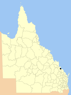
The Rockhampton Region is a local government area (LGA) in Central Queensland, Australia, located on the Tropic of Capricorn about 600 kilometres (370 mi) north of Brisbane. Rockhampton is the region's major city; the region also includes the Fitzroy River, Mount Archer National Park and Berserker Range.

Wallaville Town in Queensland, Australia

Wallaville is a rural town and locality in the Bundaberg Region, Queensland, Australia. It is 372 kilometres (231 mi) north of the state capital, Brisbane and 43 kilometres (27 mi) south west of the regional centre of Bundaberg. In the 2016 census, Wallaville had a population of 410 people.

Jambin, Queensland Town in Queensland, Australia

Jambin is a rural town and locality in the Shire of Banana, Queensland, Australia.

Morinish, Queensland Suburb of Rockhampton Region, Queensland, Australia

Morinish is a rural locality in the Rockhampton Region, Queensland, Australia. In the 2016 census Morinish had a population of 89 people.

Gladstone Central Suburb of Gladstone, Queensland, Australia

Gladstone Central is a coastal suburb of Gladstone in the Gladstone Region, Queensland, Australia. It is the historic centre and central business district of the city of Gladstone and the seat of the Gladstone Regional Council. In the 2016 census, Gladstone Central had a population of 1,547 people.

Bajool, Queensland Suburb of Rockhampton Region, Queensland, Australia

Bajool is a rural town and locality in the Rockhampton Region, Queensland, Australia. In the 2016 census, Bajool had a population of 455 people.

Gogango Town in Queensland, Australia

Gogango is a rural town and locality in the Rockhampton Region, Queensland, Australia. In the 2016 census the locality of Gogango had a population of 111 people.

Town of North Rockhampton

The Town of North Rockhampton was a local government area in Queensland, Australia. It existed from 1883 to 1919.

Yaamba Suburb of Shire of Livingstone, Queensland, Australia

Yaamba is a town and locality in the Shire of Livingstone, Queensland, Australia.

Nerimbera, Queensland Suburb of Shire of Livingstone, Queensland, Australia

Nerimbera is a rural locality in the Livingstone Shire, Queensland, Australia. In the 2016 census Nerimbera had a population of 293 people.

Lakes Creek, Queensland Suburb of Rockhampton Region, Queensland, Australia

Lakes Creek is a suburb split between Rockhampton Region and Shire of Livingstone, Queensland, Australia. In the 2016 census Lakes Creek had a population of 552 people.

Lawgi Dawes Suburb of Shire of Banana, Queensland, Australia

Lawgi Dawes is a rural locality in the Shire of Banana, Queensland, Australia. In the 2016 census Lawgi Dawes had a population of 144 people. It contains the neighbourhood of Lawgi, a former town.

Thompson Point, Queensland Suburb of Livingstone Shire, Queensland, Australia

Thompson Point is a coastal locality in the Livingstone Shire, Queensland, Australia. In the 2016 census Thompson Point had a population of 10 people. It was the site of a short-lived town and port called Broadmount.

References

  1. 1 2 Australian Bureau of Statistics (27 June 2017). "Westwood (SSC)". 2016 Census QuickStats. Retrieved 20 October 2018. OOjs UI icon edit-ltr-progressive.svg
  2. 1 2 "Westwood – town (entry 37148)". Queensland Place Names. Queensland Government . Retrieved 27 December 2015.
  3. "Westwood – locality in Rockhampton Region (entry 48930)". Queensland Place Names. Queensland Government . Retrieved 27 December 2015.
  4. "Westwood – locality in Banana Shire (entry 49579)". Queensland Place Names. Queensland Government . Retrieved 27 December 2015.
  5. "Queensland Globe". State of Queensland . Retrieved 26 December 2015.
  6. "Westwood celebrates its place in Queensland's 150 year history". statements.qld.gov.au. Archived from the original on 4 March 2016. Retrieved 26 December 2015.
  7. The Centenary of the Central Line Knowles, J.W. Australian Railway Historical Society Bulletin, September, 1967 pp181-202
  8. "Opening and closing dates of Queensland Schools". Queensland Government . Retrieved 26 December 2015.
  9. "Agency ID 5823, Westwood State School". Queensland State Archives . Retrieved 26 December 2015.
  10. "THE DOCK WAREHOUSES". Rockhampton Bulletin . XIII (1859). Queensland, Australia. 2 October 1873. p. 2. Retrieved 4 December 2021 via National Library of Australia.
  11. "WESTWOOD SANATORIUM". The Capricornian . 44 (36). Queensland, Australia. 6 September 1919. p. 31. Retrieved 13 November 2021 via National Library of Australia.
  12. "Westwood Sanatorium on its opening day 1919". Australian Country Hospital Heritage Association. Archived from the original on 16 April 2021. Retrieved 13 November 2021.
  13. "Westwood Sanatorium". The Telegraph (14, 597). Queensland, Australia. 8 September 1919. p. 7 (SECOND EDITION). Retrieved 13 November 2021 via National Library of Australia.
  14. "HAIGH DRIVE OPENED". The Central Queensland Herald (Rockhampton, Qld. : 1930 - 1956) . Rockhampton, Qld.: National Library of Australia. 5 November 1953. p. 11. Retrieved 27 December 2015.
  15. "Untitled". The Central Queensland Herald (Rockhampton, Qld. : 1930 - 1956) . Rockhampton, Qld.: National Library of Australia. 5 November 1953. p. 11. Retrieved 27 December 2015.
  16. "Westwood Sanatorium on opening day 1919". www.achha.org.au. Archived from the original on 29 February 2016. Retrieved 26 December 2015.
  17. "Westwood War Memorial". Monument Australia. Retrieved 13 June 2021.
  18. 1 2 Salecich, Judith (22 April 2017). "Remembering Westwood's first Anzac Day ceremony (1996)". Love in a little black diary. Archived from the original on 13 June 2021. Retrieved 13 June 2021.
  19. Australian Bureau of Statistics (25 October 2007). "Westwood (Fitzroy Shire) (State Suburb)". 2006 Census QuickStats. Retrieved 25 July 2009.
  20. Australian Bureau of Statistics (31 October 2012). "Westwood". 2011 Census QuickStats. Retrieved 26 December 2015. OOjs UI icon edit-ltr-progressive.svg
  21. "Adolphus William Copper Smelter and Dee Township (entry 700013)". Queensland Heritage Register . Queensland Heritage Council. Retrieved 12 July 2013.
  22. "State and non-state school details". Queensland Government. 9 July 2018. Archived from the original on 21 November 2018. Retrieved 21 November 2018.
  23. "Westwood State School". Archived from the original on 1 April 2020. Retrieved 21 November 2018.
  24. "ACARA School Profile 2017". Archived from the original on 22 November 2018. Retrieved 22 November 2018.

Further reading