Isla Gorge National Park

Last updated

Isla Gorge National Park
Queensland
IUCN category II (national park)
Isla Gorge National Park.jpg
Australia Queensland relief location map.jpg
Red pog.svg
Isla Gorge National Park
Coordinates 25°10′10″S149°56′42″E / 25.16944°S 149.94500°E / -25.16944; 149.94500 Coordinates: 25°10′10″S149°56′42″E / 25.16944°S 149.94500°E / -25.16944; 149.94500
Established 1964
Area 78.5 km2 (30.3 sq mi)
Managing authorities Queensland Parks and Wildlife Service
Website Isla Gorge National Park
See also Protected areas of Queensland

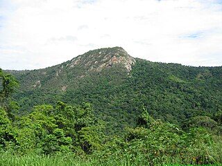
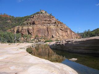
Isla Gorge is a national park in Queensland, Australia, 415 km northwest of Brisbane, gazetted in 1964. It contains a rest area with toilets and a camping area, situated along the Leichhardt Highway just south of Theodore.

Queensland North-east state of Australia

Queensland is the second-largest and third-most populous state in the Commonwealth of Australia. Situated in the north-east of the country, it is bordered by the Northern Territory, South Australia and New South Wales to the west, south-west and south respectively. To the east, Queensland is bordered by the Coral Sea and Pacific Ocean. To its north is the Torres Strait, with Papua New Guinea located less than 200 km across it from the mainland. The state is the world's sixth-largest sub-national entity, with an area of 1,852,642 square kilometres (715,309 sq mi).

Australia Country in Oceania

Australia, officially the Commonwealth of Australia, is a sovereign country comprising the mainland of the Australian continent, the island of Tasmania and numerous smaller islands. It is the largest country in Oceania and the world's sixth-largest country by total area. The neighbouring countries are Papua New Guinea, Indonesia and East Timor to the north; the Solomon Islands and Vanuatu to the north-east; and New Zealand to the south-east. The population of 25 million is highly urbanised and heavily concentrated on the eastern seaboard. Australia's capital is Canberra, and its largest city is Sydney. The country's other major metropolitan areas are Melbourne, Brisbane, Perth and Adelaide.

Brisbane capital city of Queensland, Australia

Brisbane is the capital of and the most populated city in the Australian state of Queensland, and the third most populous city in Australia. Brisbane's metropolitan area has a population of 2.5 million, and the South East Queensland region, centred on Brisbane, encompasses a population of more than 3.5 million. The Brisbane central business district stands on the historic European settlement and is situated inside a peninsula of the Brisbane River, about 15 kilometres from its mouth at Moreton Bay. The metropolitan area extends in all directions along the floodplain of the Brisbane River Valley between Moreton Bay and the Great Dividing Range, sprawling across several of Australia's most populous local government areas (LGAs)—most centrally the City of Brisbane, which is by far the most populous LGA in the nation. The demonym of Brisbane is "Brisbanite".

The national park is upon the traditional Aboriginal lands of the Kongabulla Clan of Iman country, [1] the carpet snake people, and Wulli Wulli country. [2]

The north-western section was expanded in 1990 to include the hand-laid rock road which once ran from Rockhampton to Roma as part of the wool run. [3]

See also

Related Research Articles

Carnarvon National Park Protected area in Queensland, Australia

Carnarvon National Park is located in the Southern Brigalow Belt bioregion in the Maranoa Region in Central Queensland, Australia. The park is 593 km northwest of Brisbane. It began life as a 26,304-hectare reserve gazetted in 1932 to protect Carnarvon Gorge for its outstanding scenic values, its indigenous and non-indigenous cultural heritage, and its geological significance.

Queensland is the second largest state in Australia. It contains 472 separate protected areas with a total land area of 69,388 km2 (26,791 sq mi). 223 of these are National parks, which is the highest number of any Australian state or territory, totalling 65,871 km2 (25,433 sq mi). Seven others are Scientific National Parks, totalling 522 km2 (202 sq mi).

Auburn River National Park Protected area in Queensland, Australia

Auburn River National Park is a protected area in the North Burnett Region, Queensland, Australia. It is in the north-east of the locality of Hawkwood extending into southern Dykehead.

Barron Gorge National Park Protected area in Queensland, Australia

Barron Gorge National Park is a protected area in the Cairns Region, Queensland, Australia. It is predominantly within the locality of Barron Gorge.

Blackdown Tableland National Park Protected area in Queensland, Australia

Blackdown Tableland is a national park in the Central Highlands Region, Queensland, Australia.

Cania Gorge National Park Protected area in Queensland, Australia

Cania Gorge is a national park in the North Burnett Region, Queensland, Australia.

Daintree National Park Protected area in Queensland, Australia

The Daintree rainforest is a national park in Far North Queensland, Australia, 1,502 km (933 mi) northwest of Brisbane and 100 km (62 mi) northwest of Cairns. It was founded in 1981 and is part of the Wet Tropics of Queensland. In 1988 it became a World Heritage Site. The park consists of two sections, with a settled agricultural area between them which includes the towns of Mossman and Daintree Village.

Hell Hole Gorge National Park Protected area in Queensland, Australia

Hell Hole Gorge is a national park in South West Queensland, Australia, 912 km west of Brisbane.

Boodjamulla National Park Protected area in Queensland, Australia

Boodjamulla National Park, formerly known as Lawn Hill National Park, is a national park in the Shire of Burke, Queensland, Australia.

Minerva Hills National Park Protected area in Queensland, Australia

Minerva Hills is a national park in Central Queensland, Australia, 626 km northwest of Brisbane. The park features a rugged landscape with volcanic peaks, sheltered gorges, sheer cliffs, open woodlands and dry rainforest.

Porcupine Gorge National Park Protected area in Queensland, Australia

Porcupine Gorge National Park is a national park in Porcupine, Shire of Finders in North West Queensland, Australia, 1,174 km northwest of Brisbane and 60 km north of Hughenden. Established in 1970, the national park has an area of 54.10 km² and is managed by the Queensland Parks and Wildlife Service. It is an IUCN category II park.

Sundown National Park Protected area in Queensland, Australia

Sundown is a national park in Queensland, Australia, 198 km south west of Brisbane. The park contains spectacular gorge country and a number of peaks higher than 1,000 m.

Tully Gorge National Park Protected area in Queensland, Australia

Tully Gorge is a national park in Queensland, Australia, 1,338 km northwest of Brisbane. The park forms part of the Wooroonooran Important Bird Area, identified as such by BirdLife International because it supports populations of a range of bird species endemic to Queensland's Wet Tropics.

Wallaman Falls waterfall in Girringun National Park, Queensland, Australia

The Wallaman Falls, a cascade and horsetail waterfall on the Stony Creek, is located in the UNESCO World Heritage–listed Wet Tropics in the northern region of Queensland, Australia. The waterfall is notable for its main drop of 268 metres (879 ft), which makes it the country's tallest single-drop waterfall. The pool at the bottom of the waterfall is 20 metres (66 ft) deep. An estimated 100,000 people visit the waterfall annually.

Central Queensland Region in Queensland, Australia

Central Queensland is an ambiguous geographical division of Queensland that centres on the eastern coast, around the Tropic of Capricorn. Its major regional centre is Rockhampton. The region extends from the Capricorn Coast west to the Central Highlands at Emerald, north to the Mackay Regional Council southern boundary, and south to Gladstone. The region is also known as Capricornia. It is one of Australia's main coal exporting regions.

Kuranda, Queensland Town in Queensland, Australia

Kuranda is a town and locality on the Atherton Tableland in the Shire of Mareeba, Far North Queensland, Australia. The town of Myola is also located within the locality of Kuranda. It is 25 kilometres (16 mi) from Cairns, via the Kuranda Range road. It is surrounded by tropical rainforest and adjacent to the Wet Tropics World Heritage listed Barron Gorge National Park. It is within the local government area of Shire of Mareeba.

Carnarvon Gorge

Carnarvon Gorge is located in the Southern Brigalow Belt bioregion in Central Queensland (Australia), 593 km northwest of Brisbane. Primarily created by water erosion, Carnarvon Gorge is around 30 kilometres long, located in Carnarvon National Park, and six hundred metres deep at the mouth. It is the most visited feature within Carnarvon National Park due to the diversity of experiences it contains and the ease with which it can be accessed. The closest towns are Injune and Rolleston.

Djabugay

The Djabugay people are a group of Australian Aboriginal people who are the original inhabitants of mountains, gorges, lands and waters of a richly forested part of the Great Dividing Range including the Barron Gorge and surrounding areas within the Wet Tropics of Queensland.

Shire of Taroom Local government area in Queensland, Australia

The Shire of Taroom was a local government area in the Darling Downs region of Queensland, Australia, along the Leichhardt Highway to the north of Miles. The shire covered an area of 18,644.5 square kilometres (7,198.7 sq mi), and existed as a local government area from 1879 until 2008, when it was dissolved and split between the new Western Downs Region and the Shire of Banana.

Brigalow Belt

The Brigalow Belt is a wide band of acacia wooded grassland that runs between tropical rainforest of the coast and the semi-arid interior of Queensland, Australia. See Interim Biogeographic Regionalisation for Australia for the IBRA definitions of the Brigalow Belt South (BBS) and the Brigalow Belt North (BBN) bioregions. The Northern and Southern Brigalow Belts are two of the 85 bioregions across Australia and the 15 bioregions in Queensland. Together they form most of the Brigalow tropical savanna ecoregion.

References