Black Mountain (Kalkajaka) National Park

Last updated

Black Mountain (Kalkajaka)
National Park

Queensland
IUCN category II (national park)
Black Mountain1.jpg
View of one of the black mountains from Mulligan Highway
Australia Queensland location map.svg
Red pog.svg
Black Mountain (Kalkajaka)
National Park
Nearest town or city Cooktown
Coordinates 15°40′05″S145°13′55″E / 15.66806°S 145.23194°E / -15.66806; 145.23194 Coordinates: 15°40′05″S145°13′55″E / 15.66806°S 145.23194°E / -15.66806; 145.23194
Established1980 (Register of the National Estate)
Area7.81 km2 (3.0 sq mi)
Managing authorities Queensland Parks and Wildlife Service
Website Black Mountain (Kalkajaka)
National Park
See also Protected areas of Queensland

Black Mountain (Kalkajaka) National Park is a 781-hectare (1,930-acre) protected area in Shire of Cook, Queensland, Australia. [1] [2]

Contents

Geography

The park is 25 km south west of Cooktown. It is managed and protected as a national park under the Nature Conservation Act 1992.

The main feature of the park is the mass of granite boulders, some the size of houses. The absence of soil between the boulders and rocks create a maze of gaps and passages, which can be used to penetrate inside the mountain. [3] These rocks can become extremely hot.

The area has a bad reputation as numerous people and those searching for the missing have disappeared without trace. [3] The Mulligan Highway marks the western border of the park.

Natural history

The national park’s distinctive hard black boulders (often termed granite) and range are composed of the igneous felsic intrusive Trevethan Granodiorite which is predominantly a white to grey, medium-grained, porphyritic biotite monzogranite to granodiorite. The age of the intrusive is Late Permian and has been dated from 259.1 to 251.902 million years old. The Trevethan Granodiorite was originally magma that slowly solidified under the earths crust. [4] [5]

The softer land surfaces above the solidified magma eroded away over time, leaving the magma's fractured top to be exposed as a mountain of grey granite boulders blackened by a film of microscopic blue-green algae growing on the exposed surfaces. Colder rains falling on the dark, heated granite boulders causes the boulders to progressively fracture, break, and slowly disintegrate, sometimes explosively. [5]

Cultural history

The National Park's "Black Mountains" are a heavily significant feature of the Kuku Nyungkal people's cultural landscape known locally to Aboriginal Australians as Kalkajaka (trans: "place of spear").

Queensland's Department of Environment and Natural Resources has been advised of at least four sites of particular mythological significance within the "Black Mountains" as follows: [5]

There are at least four sites of religious or mythological significance on the mountain. These are the Kambi, a large rock with a cave where flying-foxes are found; Julbanu, a big grey kangaroo-shaped rock looking toward Cooktown; Birmba, a stone facing toward Helenvale where sulphur-crested cockatoos are seen; and a taboo place called Yirrmbal near the foot of the range.

The Black Mountain also features strongly in local, more non-Aboriginal cultural landscapes, some of which has also been described by Queensland's Department of Environment and Resource Management as follows: [5]

When European colonists arrived late last century, they added to the many Aboriginal legends of the area with a few of their own. Stories abound of people, horses and whole mobs of cattle disappearing into the labyrinth of rocks, never to be seen again

It is believed that those who vanished most probably fell into one of the chasms under the rocks or after entering one of these places became lost. It is estimated only three in ten would survive such falls, wandering below the Earth's surface with only ground water streams and insects to nourish them. A minority group is referred to by colonists as the Outback Moles (perhaps in reference to New York's underground population). [3]

Ecology

The Black Mountains are located at the northernmost end of the Wet Tropics World Heritage Area, where world heritage listed wet tropical forests meet drier savanna woodlands - making it a natural refuge for once more widespread, now isolated relict fauna.

Queensland's Department of Environment and Resource Management advises, for instance, the relatively small, unusual "Black Mountain" environment is the world's only habitat for at least three animals: the Black Mountain boulderfrog or rock haunting frog ( Cophixalus saxatilis ); the Black Mountain skink ( Carlia scirtetis ); and the Black Mountain gecko ( Nactus galgajuga ). This makes the area one of Australia's most restricted habitats for endemic fauna. [5]

Facilities

Camping is not permitted in the park. There are no walking tracks and no facilities for picnics. [6] There is a viewing platform that features interpretive displays. [3]

See also

Related Research Articles

Batholith Large igneous rock intrusion

A batholith is a large mass of intrusive igneous rock, larger than 100 square kilometres (40 sq mi) in area, that forms from cooled magma deep in the Earth's crust. Batholiths are almost always made mostly of felsic or intermediate rock types, such as granite, quartz monzonite, or diorite.

Wooroonooran National Park Protected area in Queensland, Australia

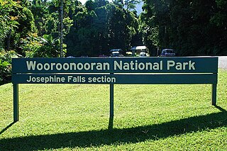
Wooroonooran [Aboriginal - "Black Rock"] is a national park in Queensland (Australia), 1367 km northwest of Brisbane, between Innisfail and Cairns.

Karlu Karlu / Devils Marbles Conservation Reserve Protected area in the Northern Territory, Australia

Karlu Karlu / Devils Marbles Conservation Reserve is a protected area in the Northern Territory of Australia located in the locality of Warumungu about 105 km (65 mi) south of Tennant Creek, and 393 km (244 mi) north of Alice Springs. The nearest settlement is the small town of Wauchope located 9 km (5.6 mi) to the south.

Intrusive rock Magmatic rock formed below the surface

Intrusive rock is formed when magma penetrates existing rock, crystallizes, and solidifies underground to form intrusions, such as batholiths, dikes, sills, laccoliths, and volcanic necks.

You Yangs

The You Yangs are a series of granite ridges that rise to 319m above the Werribee Plain approximately 55 km south-west of Melbourne and 22 km north-east of Geelong, in Victoria, Australia. The main ridge runs roughly north–south for about 9 km, with a lower extension running for about 15 km to the west. Much of the southern parts of the ranges are protected by the You Yangs Regional Park.

Granodiorite A phaneritic-textured intrusive igneous rock similar to granite

Granodiorite is a phaneritic-textured intrusive igneous rock similar to granite, but containing more plagioclase feldspar than orthoclase feldspar. According to the QAPF diagram, granodiorite has a greater than 20% quartz by volume, and between 65% to 90% of the feldspar is plagioclase. A greater amount of plagioclase would designate the rock as tonalite.

Stawamus Chief

The Stawamus Chief, officially Stawamus Chief Mountain, is a granitic dome located adjacent to the town of Squamish, British Columbia, Canada. It towers over 700 m (2,297 ft) above the waters of nearby Howe Sound. It is one of the largest granite monoliths in the world.

Wujal Wujal Town in Queensland, Australia

Wujal Wujal is a rural town and locality in the Wujal Wujal Aboriginal Shire, Queensland, Australia. In the 2016 census, Wujal Wujal had a population of 282 people. It is an Aboriginal community.

Geology of the Australian Capital Territory Overview of the geology of the Australian Capital Territory

The geology of the Australian Capital Territory includes rocks dating from the Ordovician around 480 million years ago, whilst most rocks are from the Silurian. During the Ordovician period the region—along with most of eastern Australia—was part of the ocean floor. The area contains the Pittman Formation consisting largely of Quartz-rich sandstone, siltstone and shale; the Adaminaby Beds and the Acton Shale.

Cape Tribulation, Queensland Suburb of Shire of Douglas, Queensland, Australia

Cape Tribulation is a headland and coastal locality in the Shire of Douglas in northern Queensland, Australia. In the 2016 census, Cape Tribulation had a population of 118 people.

Palmer River

The Palmer River is a river located in Far North Queensland, Australia. The area surrounding the river was the site of a gold rush in the late 19th century which started in 1873.

Black Mountain boulder frog

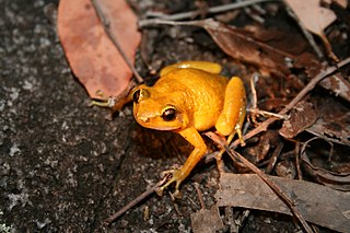
The Black Mountain boulder frog, also known as the rock haunting frog or the Black Mountain rainforest frog, is a species of frog in the family Microhylidae.

Ngarrabullgan

Ngarrabullgan, officially named Mount Mulligan by the State, is a large tabletop mountain located 100 kilometres west of Cairns in the north of Queensland (Australia).

Bloomfield River River in Far North Queensland, Australia

The Bloomfield River is a river located in the Wet Tropics of Far North Queensland, Australia, noted for its Bloomfield River cod fish species, found only in the river.

Kuku Nyungkal

The Kuku Nyungkal people are a group of Aboriginal Australians who are the original custodians of the coastal mountain slopes, wet tropical forests, waters, and waterfalls of the Upper Annan River, south of Cooktown, Queensland

Annan River

The Annan River is a river located in the Wet Tropics of Far North Queensland, Australia.

Cathedral Peak Granodiorite

The Cathedral Peak Granodiorite (CPG) was named after its type locality, Cathedral Peak in Yosemite National Park, California. The granodiorite forms part of the Tuolumne Intrusive Suite, one of the four major intrusive suites within the Sierra Nevada. It has been assigned radiometric ages between 88 and 87 million years and therefore reached its cooling stage in the Coniacian.

Igneous rock Rock formed through the cooling and solidification of magma or lava

Igneous rock, or magmatic rock, is one of the three main rock types, the others being sedimentary and metamorphic. Igneous rock is formed through the cooling and solidification of magma or lava.

Cooktown, Queensland Town in Queensland, Australia

Cooktown is a coastal town and locality in the Shire of Cook, Queensland, Australia. Cooktown is at the mouth of the Endeavour River, on Cape York Peninsula in Far North Queensland where James Cook beached his ship, the Endeavour, for repairs in 1770. Both the town and Mount Cook which rises up behind the town were named after James Cook.

Kuna Crest Granodiorite, is found, in Yosemite National Park, United States. The granodiorite forms part of the Tuolumne Intrusive Suite, one of the four major intrusive suites within the Sierra Nevada. Of the Tuolumne Intrusive Suite, it is the oldest and darkest rock.

References

  1. "Black Mountain National Park (entry 39377)". Queensland Place Names. Queensland Government . Retrieved 24 June 2017.
  2. Black Mountain National Park. Register of the National Estate.
  3. 1 2 3 4 Shilton, Peter (2005). Natural Areas of Queensland. Mount Gravatt, Queensland: Goldpress. pp. 11–13. ISBN   0-9758275-0-2.
  4. "Macrostrat". macrostrat.org. Retrieved 23 March 2020.
  5. 1 2 3 4 5 "Black Mountain (Kalkajaka) National Park: Nature, culture and history". Department of National Parks, Recreation, Sport and Racing. 7 June 2011. Retrieved 13 August 2014.
  6. "Black Mountain (Kalkajaka) National Park: About Black Mountain". Department of National Parks, Recreation, Sport and Racing. 7 June 2011. Retrieved 13 August 2014.