Smith Islands National Park

Last updated

Smith Islands National Park
Queensland
IUCN category II (national park)
Australia Queensland location map.svg
Red pog.svg
Smith Islands National Park
Coordinates 20°35′21″S149°06′38″E / 20.58917°S 149.11056°E / -20.58917; 149.11056 Coordinates: 20°35′21″S149°06′38″E / 20.58917°S 149.11056°E / -20.58917; 149.11056
Area 18.70 km2 (7.22 sq mi)
Managing authorities Queensland Parks and Wildlife Service
See also Protected areas of Queensland

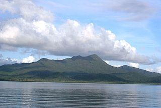
Smith Islands is a national park in North Queensland, Australia, 862 km northwest of Brisbane.

North Queensland Region in Queensland, Australia

North Queensland or the Northern Region is the northern part of the Australian state of Queensland that lies just south of Far North Queensland. Queensland is a massive state, larger than many countries, and the tropical northern part of it has been historically remote and undeveloped, resulting in a distinctive regional character and identity.

Australia Country in Oceania

Australia, officially the Commonwealth of Australia, is a sovereign country comprising the mainland of the Australian continent, the island of Tasmania and numerous smaller islands. It is the largest country in Oceania and the world's sixth-largest country by total area. The neighbouring countries are Papua New Guinea, Indonesia and East Timor to the north; the Solomon Islands and Vanuatu to the north-east; and New Zealand to the south-east. The population of 25 million is highly urbanised and heavily concentrated on the eastern seaboard. Australia's capital is Canberra, and its largest city is Sydney. The country's other major metropolitan areas are Melbourne, Brisbane, Perth and Adelaide.

Brisbane capital city of Queensland, Australia

Brisbane is the capital of and most populous city in the Australian state of Queensland, and the third most populous city in Australia. Brisbane's metropolitan area has a population of 2.5 million, and the South East Queensland region, centred on Brisbane, encompasses a population of more than 3.5 million. The Brisbane central business district stands on the historic European settlement and is situated inside a peninsula of the Brisbane River, about 15 kilometres from its mouth at Moreton Bay. The metropolitan area extends in all directions along the floodplain of the Brisbane River Valley between Moreton Bay and the Great Dividing Range, sprawling across several of Australia's most populous local government areas (LGAs) — most centrally the City of Brisbane, which is by far the most populous LGA in the nation. The demonym of Brisbane is "Brisbanite".

Smith Island is a southern island in the Family Islands group and located approximately 20 km East of Tully Heads.

Family Islands National Park Protected area in Queensland, Australia

Family Islands National Park is an Australian national park comprising a group of continental islands lying a short distance off the coast, about midway between Cairns and Townsville, in Far North Queensland. Most of the area has been designated as part of the national park.

Tully, Queensland Town in Queensland, Australia

Tully is a town and locality in the Cassowary Coast Region, Queensland, Australia. It is adjacent to the Bruce Highway approximately 140 kilometres (87 mi) south of Cairns by road and 210 kilometres (130 mi) north of Townsville. In the 2016 census, Tully had a population of 2,390 people.

The Aboriginal name for this island is Kurrambah Island.

The GBRMPA has deemed this island a Sensitive Location and limited visits to 2 per week.

Great Barrier Reef Marine Park Protected area in Queensland, Australia

The Great Barrier Reef Marine Park protects a large part of Australia's Great Barrier Reef from damaging activities. It is a vast multiple-use Marine Park which supports a wide range of uses, including commercial marine tourism, fishing, ports and shipping, recreation, scientific research and Indigenous traditional use. Fishing and the removal of artefacts or wildlife is strictly regulated, and commercial shipping traffic must stick to certain specific defined shipping routes that avoid the most sensitive areas of the park. The Great Barrier Reef is the largest and best known coral reef ecosystem in the world. Its reefs, almost 3000 in total, represent about 10 per cent of all the coral reef areas in the world. It supports an amazing variety of biodiversity, providing a home to thousands of coral and other invertebrate species, bony fish, sharks, rays, marine mammals, marine turtles, sea snakes, as well as algae and other marine plants.

See also


Related Research Articles

Queensland is the second largest state in Australia. It contains 472 separate protected areas with a total land area of 69,388 km2 (26,791 sq mi). 223 of these are National parks, which is the highest number of any Australian state or territory, totalling 65,871 km2 (25,433 sq mi). Seven others are Scientific National Parks, totalling 522 km2 (202 sq mi).

Barnard Island Group National Park Protected area in Queensland, Australia

The Barnard Island Group is a protected area in the Cassowary Coast Region, Queensland, Australia.

Brampton Islands National Park Protected area in Queensland, Australia

Brampton Islands is a national park in the Mackay Region, Queensland, Australia, 834 kilometres (518 mi) northwest of Brisbane. The park covers much of Brampton Island and all of Carlisle Island.

Broad Sound Islands National Park Protected area in Queensland, Australia

Broad Sound Islands is a national park in Shire of Livingstone, Queensland, Australia, 709 km northwest of Brisbane.

Brook Islands National Park Protected area in Queensland, Australia

The Brook Islands National Park is a national park in Cassowary Coast Region, Queensland, Australia, 1246 km northwest of Brisbane, with an area of 0.9 km2. It was established in 1994 and comprises three islands - North, Tween and Middle - which lie off the coast 7 km north-east of Cape Richards on Hinchinbrook Island and 30 km east of the nearest mainland town of Cardwell. The fourth island of the Brooks group, South Island, is not part of the national park but is protected by the Great Barrier Reef Marine Park Authority. Public access to the three islands in the national park is prohibited in order to protect breeding birds, especially the Torresian imperial-pigeon. The islands have no roads, walking tracks or other facilities. Popular activities in the waters around the islands are boating, snorkelling and fishing. The islands are managed by the Queensland Parks and Wildlife Service. The Park's IUCN category is II.

Capricornia Cays National Park Protected area in Queensland, Australia

Capricornia Cays is both a national park and a scientific national park in Queensland (Australia), located 486 km and 472 km north of the state capital Brisbane respectively. Collectively they comprise 241 ha of coral cays.

Curtis Island National Park Protected area in Queensland, Australia

Curtis Island is an island that contains Curtis Island National Park. It is in Gladstone Region, Queensland, Australia, 474 kilometres northwest of Brisbane and 40 km southeast of Rockhampton.

Frankland Group National Park Protected area in Queensland, Australia

Frankland Group is a national park in Queensland, Australia, 1353 km northwest of Brisbane. The five continental islands of the Frankland Group are High Island, Normanby Island, Mabel Island, Round Island and Russell Island, which lie about 10 km offshore, and are about 45 km south east of Cairns. They are the traditional home of the Mandingalbay Yidinji, and the Gungandji Aboriginal peoples. On 9 June 1770, on the First voyage of James Cook, Cook named the island group after Admiral Sir Thomas Frankland, 5th Baronet.

Gloucester Island National Park Protected area in Queensland, Australia

Gloucester Island is a national park in Queensland, Australia, 950 km northwest of Brisbane. It is visible from the town of Bowen. The island was seen and erroneously named "Cape Gloucester" by British explorer James Cook in 1770. The name "Cape Gloucester" has been used informally for areas on or near Gloucester Island.

Goold Island National Park Protected area in Queensland, Australia

Goold Island is a national park in Queensland, Australia, 1,250 km (780 mi) northwest of Brisbane. The island is close to the northern tip of Hinchinbrook Island off the coast from Cardwell in Rockingham Bay and is part of the Great Barrier Reef World Heritage Area.

Green Island National Park Protected area in Queensland, Australia

Green Island National Park is a protected area declared over a small coral cay of Green Island, Cairns Region, Queensland, Australia. It is known to the local Gungganyji Aboriginal peoples as Dabuukji. The Gungganyji people used the island as an initiation ground.

Hinchinbrook Island National Park Protected area in Queensland, Australia

Hinchinbrook Island National Park is situated along the Cassowary Coast Queensland, Australia. The nearest capital city is Brisbane approximately 1240 Lucinda is 135km or 1.5 hours drive north of Townsville being the closest North Queensland provincial city. Cairns a Far North Queensland provincial city is two and a half to 3 hours drive north from Cardwell. The main geographical features in the park are the rugged Hinchinbrook Island, including Mount Bowen.

Hope Islands National Park Protected area in Queensland, Australia

Hope Islands National Park is a national park in Queensland (Australia) 1,521 km north-west of Brisbane. The park consists of four islands: East Hope and West Hope, Snapper Island and Struck Island.

Keppel Bay Islands National Park Protected area in Queensland, Australia

Keppel Bay Islands are part of both a national park and a scientific national park in Queensland, Australia, respectively 538 km and 518 km northwest of Brisbane. The islands are positioned in Keppel Bay, off the coast of Yeppoon and Emu Park on the Capricorn Coast. The largest island and a popular tourist attraction is Great Keppel Island.

Nymph Island National Park Protected area in Queensland, Australia

Nymph Island is a national park in Far North Queensland, Australia, 1,636 km northwest of Brisbane. It is circular, with a lagoon in the center. The island is only about a kilometre in diameter. No point on the island appears to exceed 30 metres in altitude.

South Cumberland Islands National Park Protected area in Queensland, Australia

South Cumberland Islands is a national park in Queensland, Australia, 831 km northwest of Brisbane. It is famous for the Marine stingers which can be found in the waters of the park between October and May.

South Island National Park Protected area in Queensland, Australia

South Island is a national park in North Queensland (Australia), 692 km northwest of Brisbane and the island is part of the Lizard Island Group and is South of Lizard Island situated 270 km north of Cairns, Queensland.

Three Islands National Park Protected area in Queensland, Australia

Three Islands and Three Islands Reef are part of the Three Islands Group National Park in Far North Queensland, Australia, in the Coral Sea, 1,581 km (982 mi) northwest of Brisbane, about 44 km (27 mi) north-northeast of Cooktown.

Two Islands National Park Protected area in Queensland, Australia

Two Islands and Two Islands Reef are part of the Three Islands Group National Park in Far North Queensland, Australia, in the Coral Sea, 1,590 km (990 mi) northwest of Brisbane, about 50 km (31 mi) north-northeast of Cooktown, 10 km (6.2 mi) southeast of Cape Flattery, and 10 km (6.2 mi) north of Three Islands and Three Islands Reef.

Central Queensland Region in Queensland, Australia

Central Queensland is an ambiguous geographical division of Queensland that centres on the eastern coast, around the Tropic of Capricorn. Its major regional centre is Rockhampton. The region extends from the Capricorn Coast west to the Central Highlands at Emerald, north to the Mackay Regional Council southern boundary, and south to Gladstone. The region is also known as Capricornia. It is one of Australia's main coal exporting regions.