
Cape Melville is a national park in the Shire of Cook, Queensland, Australia.

Cedar Bay was a 56.5 km2 (21.8 sq mi) national park in the Shire of Cook, Queensland, Australia. In 2015, it became part of the Mangkalba section of the Ngalba Bulal National Park.

Lakefield is a national park in Lakefield, Shire of Cook, Queensland, Australia, 1,707 km northwest of Brisbane and 340 km north-west of Cairns by road, on Cape York Peninsula. At 5,370 km2 - making it bigger than Trinidad and Tobago and almost as big as Brunei - Lakefield is the second largest park in Queensland and a popular place for fishing and camping.

Possession Island is a small island in the Torres Strait Islands group off the coast of far northern Queensland, Australia. It is known as Bedanug or Bedhan Lag by one of the Indigenous Australian groups of Torres Strait Islander people, the Kaurareg, though the Ankamuti were also Indigenous to the island.

Cape York Peninsula is a large peninsula located in Far North Queensland, Australia. It is the largest unspoiled wilderness in northern Australia. The land is mostly flat and about half of the area is used for grazing cattle. The relatively undisturbed eucalyptus-wooded savannahs, tropical rainforests and other types of habitat are now recognized and preserved for their global environmental significance. Although much of the peninsula remains pristine, with a diverse repertoire of endemic flora and fauna, some of its wildlife may be threatened by industry and overgrazing as well as introduced species and weeds.

Palm Island is a locality consisting of an island group of 16 islands, split between the Shire of Hinchinbrook and the Aboriginal Shire of Palm Island, in Queensland, Australia. The locality coincides with the geographical entity known as the Palm Island group, also known as the Greater Palm group, originally named the Palm Isles.

Laura is a rural town and locality in the Shire of Cook, Queensland, Australia. In the 2016 census the locality of Laura had a population of 228 people.
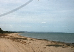
Bathurst Bay is a bay in the localities of Lakefield and Starcke in the Shire of Cook, Queensland, Australia. In the 19th century it was the base for the pearling fleet. It is now a tourist attraction on Cape York Peninsula in northern Queensland, Australia, near the Great Barrier Reef.

The Murray Falls, a cascade waterfall on the Murray River, is located in the UNESCO World Heritage–listed Wet Tropics in Murray Upper, Cassowary Coast Region in the Far North region of Queensland, Australia.

The Shire of Murweh is a local government area in the Maranoa district, which is part of South West Queensland, Australia. The administrative centre and largest town in the shire is Charleville. In June 2018, the Shire of Murweh had a population of 4,318.

Rossville is a town and coastal locality in the Shire of Cook, Queensland, Australia. In the 2016 census, Rossville had a population of 204 people.

Bloomfield is a town in the Shire of Cook and a coastal locality which is split between the Shire of Cook and the Shire of Douglas in Queensland, Australia. The neighbourhood of Ayton is within the locality. In the 2016 census, Bloomfield had a population of 204 people.
Archer River is a rural locality in the Shire of Cook, Queensland, Australia. In the 2016 census Archer River had a population of 22 people.

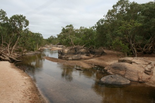
The Mossman River is a river located in the Cape York Peninsula of Far North Queensland, Australia.
Iron Range is a coastal locality in the Shire of Cook, Queensland, Australia. In the 2016 census, Iron Range had a population of 14 people. The town of Portland Road is on a north-east headland in the locality.
Mowbray is a coastal locality in the Shire of Douglas, Queensland, Australia. In the 2016 census, Mowbray had a population of 321 people.
Starcke is a coastal locality in the Shire of Cook, Queensland, Australia. In the 2016 census Starcke had a population of 3 people.
Jardine River is a coastal locality split between the Shire of Cook and the Shire of Torres in Queensland, Australia. In the 2016 census, Jardine River had a population of 0 people.
Wenlock is a rural locality in the Shire of Cook, Queensland, Australia. In the 2016 census Wenlock had a population of 3 people.
Shelburne is a locality in the Shire of Cook, Queensland, Australia. In the 2016 census, Shelburne had a population of 31 people.

