Queensland is the second largest state in Australia. It contains 472 separate protected areas with a total land area of 69,388 km2 (26,791 sq mi). 223 of these are National parks, which is the highest number of any Australian state or territory, totalling 65,871 km2 (25,433 sq mi). Seven others are Scientific National Parks, totalling 522 km2 (202 sq mi).

Alton is a national park in the Balonne Shire local government area of South West Queensland, Australia.
Chesterton Range is a national park in South West Queensland, Australia, 585 km west of Brisbane. It is located north east of Morven in both the locality of Redford in the Maranoa Region and in Tyrconnel in the Shire of Murweh. It lies in the water catchment areas of three waterways. These are the Warrego River, Wallam Creek and the Maranoa River. The park protects part of Brigalow Belt South bioregion. To the north and to the west of the park is Orkadilla State Forest.

Crows Nest is a national park on the Darling Downs of southern Queensland, Australia. It is divided into a number of section which are located in both Crows Nest and Grapetree, 40 km west of Esk in the South East Queensland bioregion. A 236 ha national park was first declared in 1967. The park has been extended south along the Great Dividing Range and now covers 17.9 km2 (6.91 sq mi).

Deepwater is a coastal national park in Queensland, Australia, 375 km north of Brisbane. It protects an area of sand dunes and coastal heaths in the Deepwater Creek catchment. The area is one of the few remaining pristine freshwater catchments on Queensland's east coast. Deepwater National Park was established in 1988 and covers 4,090 ha.

Kondalilla is a national park in the Blackall Range of South East Queensland, Australia, 91 km north of Brisbane. William Skene founded this area on his property while searching for lost cattle. He named it Bon Accord before giving it to the Queensland Government who, during the fifties, renamed it Kondalilla which is an Aboriginal word for running water. The area was first officially protected in 1906 as a recreational area, becoming a national park in 1945.

Moogerah Peaks is a National Park in the Fassifern Valley of South East Queensland, Australia, located approximately 70 km south west of the state capital Brisbane. The 676-hectare park consists of four separate protected areas which surround volcanic peaks and rocky cliffs near Moogerah Dam.
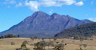
Mount Barney National Park is a national park in Queensland (Australia), 90 km southwest of Brisbane. It amalgamated the adjacent Mount Lindesay National Park in 1980. It is part of the Scenic Rim Important Bird Area, identified as such by BirdLife International because of its importance in the conservation of several species of threatened birds.
Munga-Thirri National Park, formerly known as the Simpson Desert National Park, is the largest national park in Queensland, Australia, 1,495 km west of Brisbane. The park covers an area of more than 10,000 km2 in the Simpson Desert surrounding Poeppel Corner west of Birdsville and Bedourie in the Central West region of the state.

Sundown is a national park in Queensland, Australia, 198 km south west of Brisbane. The park contains spectacular gorge country and a number of peaks higher than 1,000 m.

Tamborine is a national park in the Gold Coast hinterland and is a part of the Scenic Rim Regional Council of South East Queensland, Australia, 45 km (28 mi) south of Brisbane.
White Mountains is a national park in Queensland, Australia, 1156 km northwest of Brisbane, and 140 km south-west of Charters Towers and 80 km north-east of Hughenden.

Wondul Range is a national park in Queensland, Australia, 209 km west of Brisbane. It is located in the Toowoomba Region local government area of the Darling Downs. The park aims to conserve open woodland species typical of the Western Downs.

The Warrego Highway is located in southern Queensland, Australia. It connects coastal centres to the south western areas of the state, and is approximately 715 km in length. It takes its name from the Warrego River, which is the endpoint of the highway. The entire highway is part of the National Highway system linking Darwin and Brisbane: formerly National Highway 54, Queensland began to convert to the alphanumeric system much of Australia had adopted in the early-2000s and is now designated as National Highway A2.

Cadellia is a monotypic genus of trees in the botanical family Surianaceae. The sole species, Cadellia pentastylis, commonly known as ooline, is a medium to large tree with bright green leaves and rough tile-pattern bark. It has rain forest origins dating from the Pleistocene Era when much of Australia was wetter than it is today. It grows on moderately fertile soils, preferably those suited for agriculture or pasture development. Due to extensive forest clearing, it is now considered a vulnerable plant in Australia.

The Brigalow Belt is a wide band of acacia wooded grassland that runs between tropical rainforest of the coast and the semi-arid interior of Queensland, Australia. See Interim Biogeographic Regionalisation for Australia for the IBRA definitions of the Brigalow Belt South (BBS) and the Brigalow Belt North (BBN) bioregions. The Northern and Southern Brigalow Belts are two of the 85 bioregions across Australia and the 15 bioregions in Queensland. Together they form most of the Brigalow tropical savanna ecoregion.

Mungallala is a town in the South West region of the Australian state of Queensland. The town is in the Maranoa Region local government area and on the Warrego Highway, 608 kilometres (378 mi) west of the state capital Brisbane and 133 kilometres (83 mi) west of the regional centre of Roma. The name Mungallala is said to mean 'place of food and water'.
The Gamilaroi Nature Reserve is a protected nature reserve, part of the southern Brigalow Belt, that is located in the North West Slopes region of New South Wales, in eastern Australia. The 113-hectare (280-acre) reserve is situated 48 kilometres (30 mi) southeast of Moree, and about 6 kilometres (3.7 mi) south of Terry Hie Hie, at an elevation of 340 metres (1,120 ft) above sea level. The reserve is one of seven sites in the state where ooline occurs naturally. For this reason, the reserve is not promoted for recreation; and visits are not encouraged.


