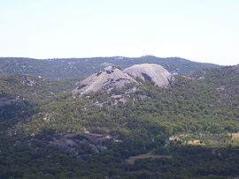
Bald Rock National Park is a national park in northern New South Wales, Australia, just north of Tenterfield on the Queensland border. The border passes over the rock on the Western side. On the other side of the border national park continues as the Girraween National Park.

The Chiltern-Mt Pilot National Park is a national park that is located in the Hume region of Victoria, Australia. The 21,650-hectare (53,500-acre) national park is situated approximately 275 kilometres (171 mi) northeast of Melbourne, and extends west from Beechworth across the Hume Freeway and the Albury-Melbourne railway line to the west of Chiltern.

The Daintree rainforest is a national park in Far North Queensland, Australia, 1,757 km (1,092 mi) northwest of Brisbane and 100 km (62 mi) northwest of Cairns. It was founded in 1981 and is part of the Wet Tropics of Queensland. In 1988 it became a World Heritage Site. The park consists of two sections, with a settled agricultural area between them which includes the towns of Mossman and Daintree Village.

Mount Walsh is a national park in Queensland, Australia, 230 km northwest of Brisbane.

The Springbrook National Park is a protected national park that is located in the Gold Coast hinterland of Queensland, Australia. The 6,197-hectare (15,310-acre) park is situated on the McPherson Range, near Springbrook, approximately 100 kilometres (62 mi) south of Brisbane. The park is part of the Shield Volcano Group of the UNESCO World Heritage–listed Gondwana Rainforests of Australia.

Sundown is a national park in Queensland, Australia, 198 km south west of Brisbane. The park contains spectacular gorge country and a number of peaks higher than 1,000 m.

Sequoia National Park is an American national park in the southern Sierra Nevada east of Visalia, California. The park was established on September 25, 1890 to protect 404,064 acres of forested mountainous terrain. Encompassing a vertical relief of nearly 13,000 feet (4,000 m), the park contains the highest point in the contiguous United States, Mount Whitney, at 14,505 feet (4,421 m) above sea level. The park is south of, and contiguous with, Kings Canyon National Park; both parks are administered by the National Park Service together as the Sequoia and Kings Canyon National Parks. UNESCO designated the areas as Sequoia-Kings Canyon Biosphere Reserve in 1976.

The Granite Belt is an area of the Great Dividing Range in the Darling Downs region of Queensland and the New England region of New South Wales, Australia. The Granite Belt is centered on the town of Stanthorpe. The cool, high country of the granite belt is located on Queensland's southern border. It is the northernmost part of the New England Tablelands.

Liston is a small mountain village in northern New South Wales, Australia in Tenterfield Shire local government area. It lies just inside the eastern boundary of the New South Wales, Queensland border on the old Cobb & Co route, now the Mount Lindesay Highway, which used to extend from Brisbane to Tenterfield, New South Wales.

The Scenic Rim is a group of forested mountain ranges of the Great Dividing Range, located south of Brisbane agglomeration, straddling the border between south-eastern Queensland and north-eastern New South Wales, Australia.

Prostanthera lasianthos, commonly known as the Victorian Christmas bush, is a large shrub or small tree of the mint family, Lamiaceae, which is native to Queensland, New South Wales, Victoria and Tasmania in Australia. It grows up to 10 m (35 ft) high but is usually much less and is found in wet sclerophyll forests, often beside creeks. Its flowers, which appear in profuse sprays, are about 2 cm long and white or pale lilac, with purple and orange blotches in the throat. They appear in late spring and summer, and specifically around Christmas time in Victoria. The fragrant, toothed leaves are 4 to 12 cm long and about 1.5 cm wide.

Phebalium whitei is a small shrub that is endemic to south-east Queensland. It has branchlets covered with silvery and rust-coloured scales, leathery, oblong to elliptic leaves and bright yellow flowers arranged in sessile umbels on the ends of branchlets.

Senecio angulatus, also known as creeping groundsel and sometimes as Cape ivy, is a succulent flowering plant in the family Asteraceae. It is native to South Africa. It is a scrambling and a twining herb that can become an aggressive weed once established, making it an invasive species in some countries. However, it is grown as an ornamental plant for its satiny foliage and sweet-scented flowers.

The Castle Crags Wilderness is a 12,232-acre (49.50 km2) wilderness area in the Castle Crags rock formations of the Trinity Mountains, and within the Shasta-Trinity National Forest, in northwestern California. It is located in Siskiyou County and Shasta County, 40 miles (64 km) north of Redding and south of Mount Shasta City.

Currumbin Valley is a rural locality in the City of Gold Coast, Queensland, Australia. It borders New South Wales. In the 2016 census, Currumbin Valley had a population of 1,849 people.
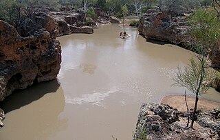
Yapunyah Waterhole lies in the Mulga Lands bioregion of western Queensland. The waterhole is about two kilometres long and covers approximately 22 hectares when full. It is defined as a permanent waterhole in a region where permanent waterholes are extremely rare and therefore provide important refuges for aquatic plants and animals. These rare waterholes were also vital for Aboriginal people and provided both spiritual and physical nourishment.
Lyra is a rural locality in the Southern Downs Region, Queensland, Australia. In the 2016 census, Lyra had a population of 53 people.

Persoonia terminalis, also known as the Torrington geebung, is a shrub belonging to the family Proteaceae, and native to northern New South Wales and southern Queensland in eastern Australia. Reported as a subspecies of Persoonia nutans in 1981, it was described as a species by Lawrie Johnson and his colleague Peter Weston in 1991.

Girraween is an undeveloped locality in the Southern Downs Region, Queensland, Australia. It in the Granite Belt and on the border with New South Wales. In the 2016 census, Girraween had a population of 12 people.

Hakea macrorrhyncha is a shrub in the family Proteaceae native to Australia. A restricted species of north-eastern New South Wales and south-eastern Queensland.