Barron Gorge National Park is a protected area in the Cairns Region, Queensland, Australia. It is predominantly within the locality of Barron Gorge.

Clump Mountain is a national park in Queensland, Australia, 1287 km northwest of Brisbane. It is part of the Coastal Wet Tropics Important Bird Area, identified as such by BirdLife International because of its importance for the conservation of lowland tropical rainforest birds.
Edmund Kennedy is a national park in Queensland, Australia, 1269 km northwest of Brisbane. The national park is part of the Wet Tropics World Heritage Area. It was named after Edmund Kennedy, a mid-nineteenth century explorer.

Ella Bay is a national park beside Ella Bay and spans the localities of Wanjuru in the Cassowary Coast Region and Eubenangee in the Cairns Region, Queensland, Australia.

Eubenangee Swamp is a national park in Eubenangee in the Cairns Region, Queensland, Australia, 1332 km northwest of Brisbane. It is part of the Coastal Wet Tropics Important Bird Area, identified as such by BirdLife International because of its importance for the conservation of lowland tropical rainforest birds.

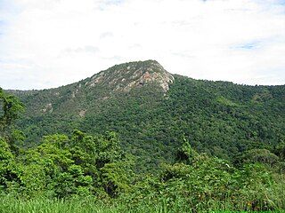
Grey Peaks is a national park in Far North Queensland, Australia, 1,374 km northwest of Brisbane. It is part of the Coastal Wet Tropics Important Bird Area, identified as such by BirdLife International because of its importance for the conservation of lowland tropical rainforest birds.

Hull River is a national park in Queensland (Australia), 1275 km northwest of Brisbane. GIS mapping data from Queensland Department of Natural Resources (2002) showed an area of 3,240 hectares, of which about 2,100 hectares are estuarine mangroves, with the remainder being swamp forests dominated by Melaleuca and specialist Eucalypt species. Rainfall averages 3,600 mm per year. The park is part of the Coastal Wet Tropics Important Bird Area, identified as such by BirdLife International because of its importance for the conservation of lowland tropical rainforest birds.
Japoon is a national park in Queensland, Australia, 1,306 km northwest of Brisbane. The park forms part of the Wooroonooran Important Bird Area, identified as such by BirdLife International because it supports populations of a range of bird species endemic to Queensland’s Wet Tropics.

Girringun National Park is a national park in Queensland, Australia, approximately 50 kilometres (31 mi) southwest of Ingham, 110 kilometres (68 mi) north of Townsville and 1,290 kilometres (800 mi) northwest of Brisbane. The park is one of the Wet Tropics World Heritage Area series of national parks, and is a gazetted World Heritage site.
Maria Creek is a national park in Far North Queensland, Australia, 1292 km northwest of Brisbane. It is part of the Coastal Wet Tropics Important Bird Area, identified as such by BirdLife International because of its importance for the conservation of lowland tropical rainforest birds.
Moresby Range is a national park in Far North Queensland, Australia, 1,314 km northwest of Brisbane. It is part of the Coastal Wet Tropics Important Bird Area, identified as such by BirdLife International because of its importance for the conservation of lowland tropical rainforest birds.

Mowbray is a national park in Queensland, Australia, 1441 km northwest of Brisbane. The park forms part of the Wooroonooran Important Bird Area, identified as such by BirdLife International because it supports populations of a range of bird species endemic to Queensland’s Wet Tropics.
Russell River is a national park in North Queensland, Australia, 1352 km northwest of Brisbane. The park protects a coastal strip between the sea and the Russell River. It is part of the Coastal Wet Tropics Important Bird Area, identified as such by BirdLife International because of its importance for the conservation of lowland tropical rainforest birds.

Tully Gorge is a national park in Queensland, Australia, 1,338 km northwest of Brisbane. The park forms part of the Wooroonooran Important Bird Area, identified as such by BirdLife International because it supports populations of a range of bird species endemic to Queensland's Wet Tropics.
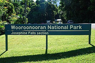
Wooroonooran [Aboriginal - "Black Rock"] is a national park in Queensland (Australia), 1367 km northwest of Brisbane, between Innisfail and Cairns.

The Daintree Rainforest is a region located on the north east coast of Queensland, Australia, north of Mossman and Cairns. At around 1,200 square kilometres (460 sq mi), the Daintree is a part of the largest continuous area of tropical rainforest on the Australian continent. The Daintree Rainforest is a part of the Wet Tropics Rainforest, that spans across the Cairns Region. The Wet Tropics Rainforest is the oldest continually surviving tropical rainforest in the world. Along the coastline north of the Daintree River, tropical forest grows right down to the edge of the sea.
The Bellenden Ker Range, also known as the Wooroonooran Range is a coastal mountain range in Far North Queensland, Australia. Part of the Great Dividing Range it is located between Gordonvale and Babinda.
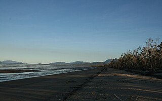
Tam O'Shanter Point is a headland located in South Mission Beach, Cassowary Coast Region, Queensland, Australia on the north-eastern part of Rockingham Bay in the Coral Sea. It is part of the Coastal Wet Tropics Important Bird Area, identified as such by BirdLife International because of its importance for the conservation of lowland tropical rainforest birds.

The Wooroonooran Important Bird Area comprises some 5125 km2 of mainly forested land in the Wet Tropics of Queensland World Heritage Site, of Far North Queensland, Australia.


