Carnarvon National Park is located in the Southern Brigalow Belt bioregion in the Maranoa Region in Central Queensland, Australia. The park is 593 km northwest of Brisbane. It began life as a 26,304-hectare reserve gazetted in 1932 to protect Carnarvon Gorge for its outstanding scenic values, its indigenous and non-indigenous cultural heritage, and its geological significance.

Chesterton Range is a national park in South West Queensland, Australia, 585 km west of Brisbane. It is located north east of Morven in both the locality of Redford in the Maranoa Region and in Tyrconnel in the Shire of Murweh. It lies in the water catchment areas of three waterways. These are the Warrego River, Wallam Creek and the Maranoa River. The park protects part of Brigalow Belt South bioregion. To the north and to the west of the park is Orkadilla State Forest.

The Daintree rainforest is a national park in Far North Queensland, Australia, 1,502 km (933 mi) northwest of Brisbane and 100 km (62 mi) northwest of Cairns. It was founded in 1981 and is part of the Wet Tropics of Queensland. In 1988 it became a World Heritage Site. The park consists of two sections, with a settled agricultural area between them which includes the towns of Mossman and Daintree Village.

Eungella is an Australian township nestled on the edge of the Clarke Range at the end of the Pioneer Valley 80 km west of Mackay, and 858 km northwest of Brisbane. Eungella is noted for the national park which surrounds it. It is considered to be the longest continual stretch of sub-tropical rainforest in Australia. The original inhabitants are the Wirri people. The park is covered by dense rainforest and is known for its platypuses. Also, it has a dam that supplies water for Collinsville, Mackay and Moranbah.
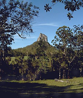
Glass House Mountains National Park is a heritage-listed national park at Glass House Mountains, Sunshine Coast Region, Queensland, Australia. It is also known as Beerburrum Forest Reserve 1. It is 70 km (43 mi) north of Brisbane and consists of a flat plain punctuated by rhyolite and trachyte volcanic plugs, the cores of extinct volcanoes that formed 27 million to 26 million years ago. The mountains would once have had pyroclastic exteriors, but these have eroded away.

The Main Range is a mountain range and national park in Queensland, Australia, located predominantly in Tregony, Southern Downs Region, 85 kilometres (53 mi) southwest of Brisbane. It is part of the World Heritage Site Gondwana Rainforests of Australia. It protects the western part of a semicircle of mountains in South East Queensland known as the Scenic Rim. This includes the largest area of rainforest in South East Queensland. The park is part of the Scenic Rim Important Bird Area, identified as such by BirdLife International because of its importance in the conservation of several species of threatened birds.

Moogerah Peaks is a National Park in the Fassifern Valley of South East Queensland, Australia, located approximately 70 km south west of the state capital Brisbane. The 676-hectare park consists of four separate protected areas which surround volcanic peaks and rocky cliffs near Moogerah Dam.
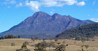
Mount Barney National Park is a national park in Queensland (Australia), 90 km southwest of Brisbane. It amalgamated the adjacent Mount Lindesay National Park in 1980. It is part of the Scenic Rim Important Bird Area, identified as such by BirdLife International because of its importance in the conservation of several species of threatened birds.

Mount Walsh is a national park in Queensland, Australia, 230 km northwest of Brisbane.

Nicoll Scrub is a national park in South East Queensland, Australia, 88 km southeast of Brisbane. It adjoins the Currumbin Valley Reserve and protects remnant rainforest vegetation. The park occupies the area between Mount Coolagang and Mount Boololagung of the McPherson Range.
Rundle Range is a national park in Central Queensland, Australia, 471 km northwest of Brisbane. The park protects portions of the Calliope River and Fitzroy River drainage basins within the Brigalow Belt bioregion.

The Springbrook National Park is a protected national park that is located in the Gold Coast hinterland of Queensland, Australia. The 6,197-hectare (15,310-acre) park is situated on the McPherson Range, near Springbrook, approximately 100 kilometres (62 mi) south of Brisbane. The park is part of the Shield Volcano Group of the UNESCO World Heritage–listed Gondwana Rainforests of Australia.
Taunton National Park is situated near the town of Dingo approximately 135 km inland from Rockhampton in eastern Central Queensland, Australia. The park encompasses an area of 11,626 ha within the Northern Brigalow Belt bioregion of Queensland; a region widely recognised to contain considerable biodiversity.

Mount Bartle Frere is the highest mountain in Queensland at an elevation of 1,611 metres (5,285 ft). The mountain was named after Sir Henry Bartle Frere, a British colonial administrator and then president of the Royal Geographical Society by George Elphinstone Dalrymple in 1873. Bartle Frere was British Governor of Cape Colony at the outset of the Zulu Wars. The Aboriginal name for the mountain is Chooreechillum.

The McPherson Range is an extensive mountain range, a spur of the Great Dividing Range, heading in an easterly direction from near Wallangarra to the Pacific Ocean coastline. It forms part of the Scenic Rim on the border between the states of New South Wales and Queensland. Further west of the McPherson Range is the Main Range. Towards the coast the range continues into the Border Ranges and other mountainous terrain formed by the Tweed Volcano.

The Wet Tropics of Queensland World Heritage Site consists of approximately 8,940 km² of Australian wet tropical forests growing along the north-east Queensland portion of the Great Dividing Range. The Wet Tropics of Queensland meets all four of the criteria for natural heritage for selection as a World Heritage Site. World Heritage status was declared in 1988, and on 21 May 2007 the Wet Tropics were added to the Australian National Heritage List.

The Bunya Mountains are a distinctive set of peaks forming an isolated section of the Great Dividing Range in southern Queensland. The mountain range forms the northern edge of the Darling Downs in the locality also called Bunya Mountains near Bell and Dalby. The mountains are south of Kingaroy and just to the south west of Nanango. The range is the remains of a shield volcano which was built from numerous basalt lava flows about 23-24 million years ago.

Cape Melville is a headland on the eastern coast of the Cape York Peninsula in Australia. To its west lies Princess Charlotte Bay. It is part of the Cape Melville National Park.
Annan River National Park is a national park on Cape York Peninsula in Far North Queensland, Australia. The Annan River from which the park gets its name, marks the northern and western extent of the park. To the east of the park is Walker Bay in the Coral Sea. The park was gazetted in 2006.
Malaan National Park is a national park in the Tablelands Region of Far North Queensland, Australia. There are two sections to the park. The largest section occupies the western third of Beatrice and the eastern fringe of Ravenshoe on the Atherton Tableland. The smaller section is in the north of Maalan. It belongs to the Wet Tropics of Queensland bioregion. The park was established to protect significant animal and plant communities. The areas were previously known as Dirran State Forest. It is adjacent to Tully Gorge National Park and Mount Fisher Forest Reserve.