
Blackwood is a national park in the Charters Towers Region, Queensland, Australia.

Central Queensland is an ambiguous geographical division of Queensland that centres on the eastern coast, around the Tropic of Capricorn. Its major regional centre is Rockhampton. The region extends from the Capricorn Coast west to the Central Highlands at Emerald, north to the Mackay Regional Council southern boundary, and south to Gladstone. The region is also known as Capricornia. It is one of Australia's main coal exporting regions.
Moranbah is a town and locality in the Isaac Region, Queensland, Australia, located on the Peak Downs Highway between Mackay and Clermont. It is a coal mining town and at the 2016 census had a population of 8,735. In addition to the permanent population, Moranbah also has a large fly-in fly-out population in excess of 1500 who work in Moranbah's mines. Moranbah services the Peak Downs Mine, Goonyella Riverside Mine, Broadmeadow Mine, Moranbah North coal mine, North Goonyella coal mine and several other smaller mines in the region. Although one of the newest towns in the region, its central location and large population has made it the seat of the Isaac Regional Council.
Dysart is a town and a locality in the Isaac Region, Queensland, Australia. Dysart is a service centre for the nearby Norwich Park coal mine, which closed in 2012, the Saraji coal mine, and the Lake Vermont Coal Mine, as well as grazing properties in the district. Most residents are employed by the coal mines. At the 2016 Census, Dysart had a population of 2,991.

The Mackenzie River is a river located in Central Queensland, Australia. The Mackenzie River is a major tributary of the Fitzroy River, part of the largest river catchment flowing to the eastern coast of Australia.
Mackenzie River is a locality in the Isaac Region, Queensland, Australia. In the 2016 census, Mackenzie River had a population of 71 people.

Carmila is a town and coastal locality in the Isaac Region, Queensland, Australia.
Everton Hills is a suburb in the Moreton Bay Region, Queensland, Australia
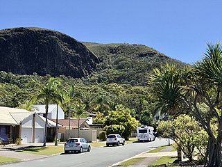
Mount Coolum is a coastal suburb and a mountain within that suburb in the Sunshine Coast Region, Queensland, Australia. In the 2016 census, Mount Coolum had a population of 4,265 people.

The Belyando River, including the Belyando River , is a river system located in Central Queensland, Australia. At 1,054 kilometres (655 mi) in length and with a catchment area of 35,000 square kilometres (14,000 sq mi), the Belyando River system is one of the longest rivers in Queensland.

The Brigalow Belt is a wide band of acacia-wooded grassland that runs between tropical rainforest of the coast and the semi-arid interior of Queensland, Australia. The Interim Biogeographic Regionalisation for Australia (IBRA) divides the Brigalow Belt into two IBRA regions, or bioregions, Brigalow Belt North (BBN) and Brigalow Belt South (BBS). The North and South Brigalow Belt are two of the 85 bioregions across Australia and the 15 bioregions in Queensland. Together they form most of the Brigalow tropical savanna ecoregion.

South West Queensland is a remote region in the Australian state of Queensland which covers 319,808 km2 (123,479 sq mi). The region lies to the south of Central West Queensland and west of the Darling Downs and includes the Maranoa district and parts of the Channel Country. The area is noted for its cattle grazing, cotton farming, opal mining and oil and gas deposits.

Ravensbourne is a rural locality in the Toowoomba Region, Queensland, Australia. In the 2016 census Ravensbourne had a population of 248 people.

Gowrie Little Plain is a rural locality in the Toowoomba Region, Queensland, Australia. In the 2016 census, Gowrie Little Plain had a population of 65 people.
Belyando is a rural locality in the Isaac Region, Queensland, Australia. In the 2016 census Belyando had a population of 66 people.
Ilbilbie is a rural town and coastal locality in the Isaac Region, Queensland, Australia. In the 2016 census the locality of Ilbilbie had a population of 349 people.
Colosseum is a rural locality in the Gladstone Region, Queensland, Australia. In the 2016 census, Colosseum had a population of 218 people.

Green Hill is a rural locality in the Cairns Region, Queensland, Australia. In the 2016 census, Green Hill had a population of 159 people.
Elgin is a rural locality in the Isaac Region, Queensland, Australia. In the 2016 census, Elgin had a population of 41 people.
The Percy Group is a locality consisting of a number of islands in the Coral Sea within the Isaac Region, Queensland, Australia. In the 2016 census, The Percy Group had a population of 0 people. The islands are uninhabitated as they are within national parks and conservation parks.
