Central Queensland Queensland | |
---|---|
Coordinates | 23°26′S144°53′E / 23.44°S 144.88°E |
Population | 233,931 (2011 census) [1] |
LGA(s) | |
State electorate(s) | |
Federal division(s) | Capricornia |
Central Queensland is an imprecisely-defined geographical division of Queensland (a state in Australia) that centres on the eastern coast, around the Tropic of Capricorn. Its major regional centre is Rockhampton. The region extends from the Capricorn Coast west to the Central Highlands at Emerald, north to the Mackay Regional Council southern boundary, and south to Gladstone. The region is also known as Capricornia. It is one of Australia's main coal exporting regions.
At the 2011 Australian Census the region recorded a total population from the six local government areas of 233,931. [1]
Economically, Central Queensland is an important centre of primary sector industries, particularly for food and fibre production. [2] Central Queensland includes the Bowen Basin which is rich in high quality coking coal, the Port of Gladstone produces 40% of the state's export earnings, the Fitzroy River is the second-largest river system in Australia and commands significant water resources such as Fairbairn Dam. Gladstone has a significant aluminium smelter.
Rockhampton is claimed to be the beef capital of Australia, a title which is disputed by Casino in New South Wales. [3] Beef production in the region is centred on Brigalow and speargrass land types. [4] Every three years, Rockhampton holds the national Beef Australia exposition to celebrate the cattle industry as well as to facilitate trade opportunities for Australian beef producers. [5]
Central Queensland is one of the world's leading producers and exporters of black coal. [6] Ludwig Leichhardt was the first European to discover coal deposits in the region in 1845. [7] In the 2011-2012 financial year the region produced 40% of the state's total coal production. [8]
Coal is extracted from the Bowen Basin and transported to port facilities at Port of Gladstone via the Blackwater railway system or to both Hay Point and Abbot Point via the Goonyella railway line. Coal mining is expanding west into the Galilee Basin and requires an extension of the Goonyella line to transport coal to port. Many mines in the region, particularly those within the Fitzroy River basin, were severely impacted by flooding during the 2010–11 Queensland floods. [9]
Gold, silver, limestone, coal seam gas, magnesite and gemstones are also mined. [6] Sapphires were discovered here in 1875. [10] Gold was discovered in the Mount Morgan region around 1865. Mount Morgan Mine has since gone on to become one of Australia's richest mines. [11]
Purpose-built mining towns in Central Queensland include Dysart, Middlemount, Moranbah, Mount Morgan and Moura. Three mining disaster have occurred at Moura since 1975, resulting in the loss of 36 lives. [12]
In 2004, an orchard on Evergreen farm was the site of the first detection of citrus canker in Central Queensland. A significant part of the citrus growing industry was devastated when a total of 6,000 acres (24 km2) of crop had to be destroyed so the disease would not spread across the country. [13] In 2005 several fresh outbreaks were reported so the eradication expanded to include private backyard trees. [14] The outbreak's cause has not been fully explained despite a federal inquiry. [13] In 2009 authorities from the Government of Queensland declared the eradication program complete.
The region contain 33 national parks. Great Keppel Island has been an island tourist attraction since the 1960s. It and several other islands in the area are surrounded by coral reefs. [15] In the west of the region is Queensland's central highlands and the Carnarvon Gorge, which is protected within the Carnarvon National Park. Carnarvon Gorge features white sandstone cliffs, steep-sided gorges a diverse range of significant plant and animal species and many walking tracks. [16] Kroombit Tops National Park provides habitat for the endemic Kroombit tinker frog. Deepwater National Park is good place for turtle watching. From November to March three species of turtle lay their eggs on beaches protected within the park. [17]
For this purpose the area of Central Queensland was restricted to the areas encircled by the Dawson Highway between Gladstone and Springsure; the Gregory Highway between Springsure and Clermont, and the Peak Downs Highway between Clermont and enters North Queensland via Mackay – extended right to the eastern coastline.
Major cities in the region are Emerald, Gladstone and Rockhampton. Some communities on the Capricorn Coast include Byfield, Yeppoon, Great Keppel Island, Emu Park and Cawarral.
Gungabula (also known as Kongabula and Khungabula) is an Australian Aboriginal language of the headwaters of the Dawson River in Central Queensland. The language region includes areas within the local government area of Maranoa Region, particularly the towns of Charleville, Augathella and Blackall and as well as the Carnarvon Range. [18]
Wadja (also known as Wadjigu, Wadya, Wadjainngo, Mandalgu, and Wadjigun) is an Australian Aboriginal language in Central Queensland. The language region includes the local government areas of the Aboriginal Shire of Woorabinda and Central Highlands Region, including the Blackdown Tablelands. the Comet River, and the Expedition Range, and the towns of Woorabinda, Springsure and Rolleston. [19]
Yagalingu (also known as Jagalingu, Auanbura, Kokleburra, Owanburra, Kowanburra, Wagalbara, and Djagalingu) is an Australian Aboriginal language of Central Queensland. Its traditional language region was within the local government area of Isaac Region, from the headwaters of the Belyando River south to Avoca, north to Laglan, west to the Great Dividing Range, and east and south to Drummond Range. [20]
Yambina (also known as Jambina and Jambeena) is an Australian Aboriginal language of Central Queensland. Its traditional language region is the local government area of Central Highlands Region, including Peak Downs, Logan Creek, south to Avon Downs, east to Denham Range and Logan Downs, west to Elgin Downs and at Solferino. [21]
Yetimarala (also known as Jetimarala, Yetimaralla, and Bayali) is an Australian Aboriginal language of Central Queensland. Its traditional language region is within the local government areas of Central Highlands Region, on the Boomer Range and Broadsound Range and the Fitzroy River, Killarney Station, Mackenzie River and Isaac River. [22]
In 1889 Central Queenslanders in Rockhampton established the Central Queensland Territorial Separation League with the hopes of turning Central Queensland into its own state. The core argument of secessionist movement was that the seat of government, Brisbane was in the south-east corner of the State. It was so far removed from substantial portions of the state that these areas and their citizens were left disadvantaged and neglected as political and economic interests focused on the south. Supplementing the Central Queensland Territorial Separation League, the women of Rockhampton established their own separation league in October 1892. Their main focus was preparing a petition to Queen Victoria. The introductory text set out their grievances and described the immense size of Queensland: being twelve times the area of England and Wales, and larger than France, Germany, Spain and Portugal combined. [23]
Central Queensland University has a campus at Emerald, Gladstone and Rockhampton.
The Central Highlands Regional Council operates the following library branches: [24]
Blackdown Tableland is a national park in the Central Highlands Region, Queensland, Australia.
Rockhampton is a city in the Rockhampton Region of Central Queensland, Australia. In the 2021 census, the population of Rockhampton was 79,293.
The Fitzroy River is a river in Central Queensland, Australia. Its catchment covers an area of 142,665 square kilometres (55,083 sq mi), making it the largest river catchment flowing to the eastern coast of Australia. It is also the largest river basin that discharges onto the Great Barrier Reef.
Emerald is a rural town and locality in the Central Highlands Region, Queensland, Australia. In the 2021 census, the locality of Emerald had a population of 14,906 people.
Rolleston is a rural town and locality in the Central Highlands Region, Queensland, Australia. In the 2016 census, the locality of Rolleston had a population of 309 people.
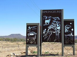
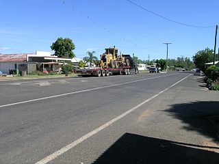
Springsure is a rural town and locality in the Central Highlands Region, Queensland, Australia. In the 2021 census, the locality of Springsure had a population of 950 people.
Far North Queensland (FNQ) is the northernmost part of the Australian state of Queensland. Its largest city is Cairns and it is dominated geographically by Cape York Peninsula, which stretches north to the Torres Strait, and west to the Gulf Country. The waters of Torres Strait include the only international border in the area contiguous with the Australian mainland, between Australia and Papua New Guinea.
The Shire of Peak Downs was a local government area in the Central Highlands of Queensland, Australia, 320 km west of both Rockhampton and Mackay. On 15 March 2008 the shires of Duaringa, Emerald, Bauhinia and Peak Downs were amalgamated to form the Central Highlands Region.
North Queensland or the Northern Region is the northern part of the Australian state of Queensland that lies just south of Far North Queensland. Queensland is a massive state, larger than many countries, and its tropical northern part has been historically remote and undeveloped, resulting in a distinctive regional character and identity.
Expedition Range is a mountain range within the Central Highlands sandstone region of Queensland, Australia. Robinson Creek cuts a 100 metres deep gorge through sandstone clifflines. Many spectacular side gorges add to the appeal of the area, which is included in the Expedition National Park.
The Mackenzie River is a river in Central Queensland, Australia. The Mackenzie River is a major tributary of the Fitzroy River, part of the largest river catchment flowing to the eastern coast of Australia.
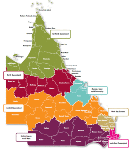
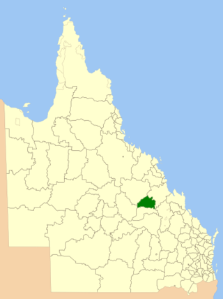
Central Highlands Region is a local government area in Queensland, Australia.
The Gulf Country or North West Queensland is the region of woodland and savanna grassland surrounding the Gulf of Carpentaria in north western Queensland and eastern Northern Territory on the north coast of Australia. The region is also called the Gulf Savannah. The Gulf Country is crossed by the Savannah Way highway.
The Nogoa River is a river in Central Queensland, Australia.
The Comet River is a river in Central Queensland, Australia.
The Carnarvon Range is a mountain range in Central Queensland, Australia. It is a plateau section of the Great Dividing Range. The Carnarvon Range is 160 km in length.
The Aboriginal Shire of Woorabinda is a local government area in Central Queensland, Australia.
Bidjara, also spelt Bidyara or Pitjara, is an Australian Aboriginal language. In 1980, it was spoken by 20 elders in Queensland between the towns of Tambo and Augathella, or the Warrego and Langlo Rivers. There are many dialects of the language, including Gayiri and Gunggari. Some of them are being revitalised and are being taught in local schools in the region. The various dialects are not all confirmed or agreed by linguists.
Western Queensland encompasses the three western regions in the Australian state of Queensland:
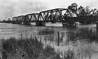
The Central Western railway line is a railway line in Queensland, Australia. It was opened in a series of sections between 1867 and 1928. It commences at Rockhampton and extends west 863 kilometres (536 mi) to Winton.
Media related to Central Queensland at Wikimedia Commons