Gregory Highway

Last updated

Gregory Highway

Gregory Developmental Road

Gregory Highway 1112.svg
Gregory Highway (yellow on black), Gregory Developmental Road (green on black)
General information
TypeHighway
Length930 km (578 mi)
Route number(s)
  • N none.svg No shield
  • (Kennedy Developmental Road – Conjuboy)
  • Australian state route 63.svg State Route 63
  • (Conjuboy – Charters Towers)
  • AUS Alphanumeric Route A7.svg State Highway A7 [1]
  • (Charters Towers – Springsure)
Former
route number
Australian national route 55.svg National Route 55
(Charters Towers – Springsure)
Major junctions
North endAustralian national route 1.svg Gulf Developmental Road (National Route 1), Mount Surprise, Queensland
 
South endAUS Alphanumeric Route A7.svg Dawson Highway (State Highway A7), Springsure, Queensland
Location(s)
Major settlements Charters Towers, Belyando, Clermont, Emerald
Highway system

The Gregory Highway is a state highway in Queensland, Australia that serves the major coal-mining centres of Central Queensland. [2] The highway was named after Augustus Gregory, an early explorer.

Contents

Route description

The highway runs southward from Quartz Blow Creek, a point 31 kilometres (19 mi) west of Mount Surprise on the Gulf Developmental Road, via Charters Towers, to Springsure, over 900 kilometres (560 mi) away. [3] The northern section of 756 kilometres (470 mi) is designated by the state government as the Gregory Developmental Road. The shorter southern section between Clermont and Springsure (174 kilometres (108 mi)) is designated the Gregory Highway. As of 2015, the first 120 kilometres (75 mi) between the Gulf Developmental Road via Einasleigh to the Lynd Junction are unsealed and may be corrugated. The next section to Charters Towers has been upgraded from single lane to mostly dual-laned bitumen. [3] The road is used by many road trains.

Northern Australia Beef Roads upgrades

The Northern Australia Beef Roads Program announced in 2016 included the following project for the Gregory Developmental Road.

Road widening

The project to widen the road south of Charters Towers is expected to be completed in early 2023 at a total cost of $5.79 million. [4]

Roads of Strategic Importance upgrades

The Roads of Strategic Importance initiative, last updated in March 2022, includes the following projects for the Gregory Highway.

Corridor upgrade

A lead project to upgrade the Townsville to Roma corridor, including sections of the Carnarvon, Dawson and Gregory Highways and surrounding state and council roads, at an estimated cost of $125 million, commenced construction of some work projects in 2020. Planning continues for other projects. [5]

Intersection upgrade Capricorn Highway

A project to upgrade the intersection with the Capricorn Highway in Emerald at a cost of $7.9 million is scheduled for completion in mid-2023. [6] This project was targeted for "early works" by the Queensland Government. [7]

Pavement strengthening and widening

A project to strengthen and widen sections of pavement on the Gregory Developmental Road between Charters Towers and The Lynd at a cost of $15.3 million is planned to be completed in mid-2023. [8] This project is targeted for "early works" by the Queensland Government. [7]

Other upgrades

A project to widen and strengthen 7 kilometres (4.3 mi) of pavement between Marble Creek and Christmas Creek, at a cost of $45.41 million, was due to be completed in late 2023. [9]

A project to upgrade a culvert near Porphyry Road, at a cost of $5,1 million, was due to be completed in late 2023. [9]

Proposals

The Queensland Inland Freight Route is a proposal to upgrade the existing highways from Charters Towers to Mungindi. This would involve significant upgrades to the Gregory Highway between Charters Towers and Springsure.

List of towns along the Gregory Developmental Road/Highway

Gregory Highway passes through Capella, 2016 Main street, Capella, 2016.jpg
Gregory Highway passes through Capella, 2016

Major intersections

LGALocationkmmiDestinationsNotes
Etheridge Mount Surprise 00.0Australian national route 1.svg Gulf Developmental Road (National Route 1) – west – Georgetown /
east – Mount Surprise
Northern end of Gregory Developmental Road (No route number)
Conjuboy 12075Australian state route 62.svg Kennedy Developmental Road (State Route 62) – west, then south – Hughenden /
east – Greenvale
Western concurrency terminus with Kennedy Developmental Road
12376Australian state route 62.svg Kennedy Developmental Road (State Route 62) – north – Mount Garnet Eastern concurrency terminus with Kennedy Developmental Road
12376Australian state route 62.svg Kennedy Developmental Road (State Route 62) – north – Mount GarnetGregory Developmental Road continues south-east as State Route 63
Charters Towers Basalt 284176Australian state route 72.svg Hervey Range Road (State Route 72) – east – Hervey Range
Charters Towers 382237AUS Alphanumeric Route A6.svg Flinders Highway (State Route A6) – east – Townsville Northern concurrency terminus with Flinders Highway /
Gregory Developmental Road continues south-west through Charters Towers
Black Jack 390240AUS Alphanumeric Route A6.svg Flinders Highway (State Route A6) – west – Pentland Southern concurrency terminus with Flinders Highway
390240AUS Alphanumeric Route A6.svg Flinders Highway (State Route A6) – west – PentlandGregory Developmental Road continues south as State Route A7. [1]
Isaac Belyando 588365Australian state route 77.svg Bowen Developmental Road (State Route 77) – east – Mount Coolon
Clermont 741460Australian state route 70.svg Peak Downs Highway (State Route 70) – east – Nebo Northern concurrency terminus with Peak Downs Highway
755469Australian state route 70.svg Peak Downs Highway (State Route 70) – south – ClermontSouthern concurrency terminus with Peak Downs Highway /
Gregory Highway continues east as State Route A7
Central Highlands Emerald 862536AUS Alphanumeric Route A4.svg Capricorn Highway (State Route A4) – west – Alpha Western concurrency terminus with Capricorn Highway
864537AUS Alphanumeric Route A4.svg Capricorn Highway (State Route A4) – east – Blackwater Eastern concurrency terminus with Capricorn Highway
Springsure 930580AUS Alphanumeric Route A7.svg Dawson Highway (State Route A7) – south–east – Rolleston Southern end of Gregory Highway /
State Route A7 continues south-east as Dawson Highway
1.000 mi = 1.609 km; 1.000 km = 0.621 mi

See also

Australia road sign W5-29.svg   Australian Roadsportal

Related Research Articles

<span class="mw-page-title-main">New England Highway</span> Highway in New South Wales and Queensland

New England Highway is an 883-kilometre (549 mi) long highway in Australia running from Yarraman, north of Toowoomba, Queensland at its northern end to Hexham at Newcastle, New South Wales at its southern end. It is part of Australia's National Highway system, and forms part of the inland route between Brisbane and Sydney.

<span class="mw-page-title-main">Capricorn Highway</span> Highway in Queensland, Australia

The Capricorn Highway is located in Central Queensland, Australia, and links the city of Rockhampton with western Queensland. The highway is 575 kilometres (357 mi) long, and joins the Landsborough Highway at Barcaldine. Formerly National Route 66, Queensland began to convert to the alphanumeric system much of Australia had adopted in the early-2000s and is now designated as A4. The highway runs parallel with the Tropic of Capricorn, hence its name.

<span class="mw-page-title-main">Flinders Highway, Queensland</span> Highway in Queensland, Australia

The Flinders Highway is a highway that crosses Queensland east to west, from Townsville on the Pacific coast to Cloncurry. The road continues as the Barkly Highway from Cloncurry to the Northern Territory border at Camooweal and beyond. The Flinders Highway passes a number of small outback towns and typical outback landscape predominates towards the inland. It was known as National Route 78 before Queensland began to convert to the alphanumeric system being adopted in Australia and is now designated as A6. The highway is also known as Overlanders Way. Its entire length is part of the National Land Transport Network.

<span class="mw-page-title-main">Carnarvon Highway</span>

Carnarvon Highway is a state highway in Queensland and New South Wales, Australia, linking the township of Rolleston in Queensland's Central Highlands Region, via the town of St George, eventually to Moree in northern New South Wales. It is the main access road to the Carnarvon National Park, and serves as a strategic route to take B-doubles and other large vehicles to the Queensland ports north of Rockhampton.

<span class="mw-page-title-main">Dawson Highway</span>

The Dawson Highway is a state highway in Queensland, Australia. It runs for 405 kilometres (252 mi) between Gladstone and Springsure where it terminates. From Gladstone to Rolleston it is signed as State Route 60, and then A7 onwards to Springsure. It continues west for another 247 kilometres (153 mi) as Dawson Developmental Road to Tambo on the Landsborough Highway. North of Springsure, A7 becomes the Gregory Highway.

<span class="mw-page-title-main">Burnett Highway</span> Highway in Queensland, Australia

The Burnett Highway is an inland rural highway located in Queensland, Australia. The highway runs between its junction with the Bruce Highway at Gracemere, just south of Rockhampton, and Nanango. Its length is approximately 542 kilometres. The highway takes its name from the Burnett River, which it crosses in Gayndah. The Burnett Highway provides the most direct link between the northern end of the New England Highway and Rockhampton. It is designated as a State Strategic Road by the Queensland Government.

<span class="mw-page-title-main">Landsborough Highway</span> Highway in Queensland, Australia

Landsborough Highway is a highway in western Queensland, Australia, running in the northwest–southeast direction from Morven to Cloncurry. The Landsborough Highway runs through vast tracts of land that was once occupied by William Landsborough, an Australian explorer of the 19th century. It is also the central part of the tourist route known as the Matilda Way after the popular Australian song Waltzing Matilda, which extends from Bourke in central northern New South Wales to Karumba on the Gulf of Carpentaria.

<span class="mw-page-title-main">Kennedy Highway</span> Highway in Queensland, Australia

The Kennedy Highway is a highway in northern Queensland, Australia. It runs as National Route 1 for approximately 243 km from Smithfield, on the northern outskirts of Cairns, to the Gulf Developmental Road in the vicinity of Forty Mile Scrub and Undara Volcanic national parks. South of this junction, the road continues as the Kennedy Developmental Road to Boulia about 936 kilometres away, via Hughenden. West of the junction, National Route 1 continues as the Gulf Developmental Road to Normanton.

<span class="mw-page-title-main">Peak Downs Highway</span> Highway in Queensland, Australia

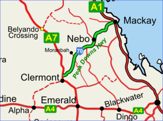
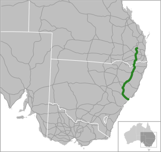
The Peak Downs Highway links the towns of Mackay and Clermont in the Australian state of Queensland. It represents the main link between Queensland's Whitsunday Coast and the Central West region of the state. The highway runs for a total length of 266 kilometres (165 mi), before joining the Gregory Highway south to Clermont, a total of 283 kilometres (176 mi). Major settlements served by this route include Walkerston, Nebo, Moranbah and Clermont.

<span class="mw-page-title-main">Gulf Developmental Road</span> Highway in Queensland, Australia

Gulf Developmental Road is an Australian highway linking the Cairns and Normanton regions in northern Queensland, Australia. It is the only sealed (asphalt) road linking these two regions.

<span class="mw-page-title-main">Buntine Highway</span> Highway in the Northern Territory and Western Australia

The Buntine Highway is a 581-kilometre highway in the Northern Territory and Western Australia. It runs from the Victoria Highway via Top Springs and Kalkarindji and then to Nicholson, Western Australia. The section from the Victoria Highway to Kalkaringi is a single-lane sealed road with a few dual-lane sections; the remaining section is unsealed. Funding for maintenance is provided by the Northern Territory government.

<span class="mw-page-title-main">Burke Developmental Road</span> Road in Queensland, Australia

The Burke Developmental Road is a Queensland (Australia) developmental road. It links Cloncurry and Normanton in a south–north direction, then turns to the north-east 30 km (19 mi) north of Normanton for 230 km (140 mi) before turning south-east till Dimbulah, where it becomes the Mareeba Dimbulah Road.

<span class="mw-page-title-main">Peninsula Developmental Road</span>

The Peninsula Developmental Road (PDR) runs 571 km (355 mi) from Lakeland to Weipa. It is the main road transport link within Cape York Peninsula and to the rest of the Australian mainland.

<span class="mw-page-title-main">Diamantina Developmental Road</span> Road in Queensland

The Diamantina Developmental Road is a gazetted road in Queensland, Australia, that runs from Charleville in the south-central part of the state to Mount Isa in the north-west.

<span class="mw-page-title-main">Bowen Developmental Road</span>

Bowen Developmental Road is a rural strategic main road in Queensland, Australia. It is part of State Route 77, and functions as a highway. It has a length of 259 kilometres (161 mi) and extends in northeast-southwest direction from Bowen on the east coast of Australia to the Gregory Developmental Road in Belyando near Nairana National Park.

The Great Inland Way is an Australian road route from Sydney, New South Wales to Cairns in Queensland. It has been designated by the Queensland Government as a State Strategic Touring Route.

Northern Australia Roads Program is a suite of projects designed to deliver upgrades to high priority roads in northern Australia. In 2016 the Australian Government announced 19 projects to be funded under this program, and in 2020 another was added. This program is separate to the Northern Australia Beef Roads Program, also announced in 2016, which contains a further 18 projects.

Queensland Inland Freight Route is a proposal to upgrade the existing highways from Charters Towers to Mungindi in Queensland, Australia. It would be a quality two-lane alternative freight route to the Bruce Highway.

Roads of Strategic Importance in Queensland is a list of roads in Queensland, Australia, that are the subject of one or more road improvement projects under the Roads of Strategic Importance (ROSI) initiative of the Australian Government. The purposes of this document are to:

Hervey Range Developmental Road is a continuous 125-kilometre (78 mi) road route in the Townsville and Charters Towers local government areas of Queensland, Australia. It is designated as State Route 72. It is a state-controlled regional road.

References

  1. 1 2 "Queensland Globe". State of Queensland . Retrieved 5 December 2019.
  2. Queensland Government - Department of Transport and Main Roads - Maps
  3. 1 2 Hema, Maps (2007). Australia Road and 4WD Atlas (Map). Eight Mile Plains Queensland: Hema Maps. pp. 10&13. ISBN   978-1-86500-456-3.
  4. "Gregory Developmental Road - South of Charters Towers - Widening". Department of Infrastructure, Transport, Regional Development and Communications. 20 September 2021. Retrieved 30 March 2022.
  5. "Townsville to Roma Corridor Upgrade". Department of Infrastructure, Transport, Regional Development and Communications. 29 March 2022. Retrieved 6 May 2022.
  6. "Capricorn Highway and Gregory Highway Intersection Upgrade (Emerald)". Department of Infrastructure, Transport, Regional Development and Communications. 17 May 2021. Retrieved 6 May 2022.
  7. 1 2 "ROSI early works package" (PDF). Queensland Government. 29 April 2020. Retrieved 7 May 2022.
  8. "Gregory Developmental Road (Charters Towers - The Lynd) - Feeder Road - Pavement Strengthening and Widening". Department of Infrastructure, Transport, Regional Development and Communications. 24 May 2021. Retrieved 6 May 2022.
  9. 1 2 "Gregory Developmental Road (Charters Towers - Lynd), package of works". Queensland Government. 22 November 2021. Retrieved 22 June 2022.