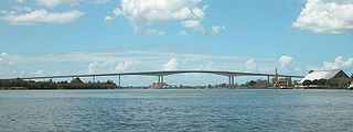
The Sir Leo Hielscher Bridges, formerly and still commonly known as the Gateway Bridge, are a side-by-side pair of road bridges on the Gateway Motorway (M1), which skirts the eastern suburbs of Brisbane, Queensland, Australia. The western bridge carries traffic to the north and the eastern bridge carries traffic to the south. They are the most eastern crossings of the Brisbane River and the closest to Moreton Bay, crossing at the Quarries Reach and linking the suburbs of Eagle Farm and Murarrie. The original western bridge was opened on 11 January 1986 and cost A$92 million to build. The duplicate bridge was opened in May 2010, and cost $350 million.

Pacific Highway is a 790-kilometre-long (491 mi) national highway and major transport route along the central east coast of Australia, with the majority of it being part of Australia's Highway 1. The highway and its adjoining Pacific Motorway between Brisbane and Brunswick Heads and Pacific Motorway between Sydney and Newcastle links the state capitals of Sydney in New South Wales with Brisbane in Queensland, approximately paralleling the Tasman Sea and the Coral Sea of the South Pacific Ocean coast, via regional cities and towns like Gosford, Newcastle, Taree, Port Macquarie, Kempsey, Coffs Harbour, Grafton, Ballina, Byron Bay, Tweed Heads and the Gold Coast, which is part of Queensland. Additionally, between Brunswick Heads and Port Macquarie, the road is also signed as Pacific Motorway, but has not been legally gazetted as such.

The Bruce Highway is a major highway in Queensland, Australia. Commencing in the state capital, Brisbane, it passes through areas close to the eastern coast on its way to Cairns in Far North Queensland. The route is part of the Australian National Highway and also part of Highway 1, the longest highway route in Australia. Its length is approximately 1,679 kilometres (1,043 mi); it is entirely sealed with bitumen. The highway is named after a popular former Queensland and federal politician, Harry Bruce. Bruce was the state Minister for Works in the mid-1930s when the highway was named after him. The highway once passed through Brisbane, but was truncated at Bald Hills when the Gateway Motorway became National Highway 1 upon its opening in December 1986.

Princes Motorway is a 62-kilometre (39 mi) predominantly dual carriage untolled motorway that links Sydney to Wollongong and further south through the Illawarra region to Oak Flats. Part of the Australian Highway 1 network, the motorway is designated route M1.
Southern Expressway is an 18.5 km (11.5 mi) freeway through the southern suburbs of Adelaide, South Australia. It is the southern part of the North–South Corridor which extends the full length of Adelaide and is being built to urban freeway standard. It is designated part of route M2.
Port Wakefield Highway is an important South Australian highway, connecting Adelaide to the Yorke Peninsula, Port Augusta, northern and western South Australia, the Northern Territory and Western Australia. It is designated National Highway A1 and a part of the National Highway. It is named after Port Wakefield, the first government town north of Adelaide.

The Pacific Motorway is a motorway in Australia between Brisbane, Queensland, and Brunswick Heads, New South Wales, through the New South Wales–Queensland border at Tweed Heads.
The Gympie Arterial Road is a freeway in the northern suburbs of Brisbane in Queensland, Australia. The road starts in Carseldine at Gympie Road and terminates at the Gateway Motorway where it becomes the Bruce Highway. It is three lanes in each direction from Carseldine to the Strathpine Road intersection, and two lanes to the Gateway Motorway.
The Sunshine Motorway is a thirty-three kilometre Australian motorway on the Sunshine Coast region of Queensland, just north of Brisbane. It was initially a tolled motorway before these were removed in 1996 after excessive complaints regarding the need of a toll. It is part of State Route 70, which extends north a further 12.3 kilometres to Noosaville.

M1 Pacific Motorway is a 127-kilometre motorway linking Sydney to Newcastle via the Central Coast and Hunter regions of New South Wales. Formerly known but still commonly referred to by both the public and the government as the F3 Freeway, Sydney–Newcastle Freeway, and Sydney–Newcastle Expressway, it is part of the AusLink road corridor between Sydney and Brisbane.
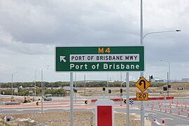
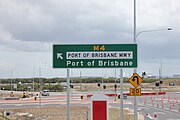
The Gateway Motorway is a major tolled motorway in Brisbane, Queensland, Australia which includes the Sir Leo Hielscher Bridges. The motorway is operated by toll road operator Transurban.

The Ipswich Motorway (M7) is a major road that connects Brisbane and Ipswich in South East Queensland, Australia. It commences at the junction of Ipswich Road and Granard Road and proceeds through to the M2 Logan Motorway interchange. It is then signed M2 until the junction of the Warrego Highway and the Cunningham Highway.

The Western Freeway is a 5-kilometre-long (3.1 mi) freeway in western Brisbane that runs from Milton Road in Toowong to the western side of Indooroopilly where the freeway becomes the M5 Centenary Motorway. The freeway bears the symbol and forms part of Metroad 5. There is one interchange, at Indooroopilly onto Moggill Road. A bicycle path runs the length of the freeway, allowing commuting to Toowong and onto Brisbane by bicycle.

The Townsville Ring Road is a motorway in Townsville, Queensland, Australia. The road has been constructed as the new A1/M1 route that bypasses the inner metro area of Townsville. The road was built in 5 stages with the first stage, the Douglas Arterial Road, opened in April 2005 and the most recent section opened in October 2023. Stage 5 commenced construction in July 2021 which included the duplication of the remaining 6-kilometre 2-lane undivided section between Vickers Bridge and Shaw Road in Thuringowa. There is no toll for the use of this motorway.
TransApex was a road transport plan devised by Brisbane Lord Mayor Campbell Newman in the early 2000s to connect existing motorways and major arterial roads with new transport links and divert cross-city traffic out of the Brisbane central business district. The plan is currently being delivered by Brisbane City Council at an estimated total cost of over $10 billion across five stages. According to the Brisbane City Council website, TransApex is "the biggest urban road project proposed in Australia".

The M5 (Centenary Motorway) is a 43-kilometre (27 mi) motorway in the western suburbs of Brisbane, Australia.

M3 Inner City Bypass (ICB) is a 5.6 kilometres (3.5 mi) major motorway standard bypass in Brisbane, Queensland, Australia. Bypassing the Brisbane central business district to the north, it connects Brisbane’s Pacific Motorway and Go Between Bridge at Hale Street to Kingsford Smith Drive, Legacy Way Tunnel, Clem Jones Tunnel, AirportLink Tunnel and Lutwyche Road following the Exhibition railway line for the majority of its length.
Nerang–Broadbeach Road is a road on the Gold Coast, Queensland, Australia. It is classified a state-controlled district road, and is part of State Route 90. The eastern section is also known as Hooker Boulevard.

The North–South Motorway is a partially complete motorway traversing the inner western suburbs of Adelaide, from Waterloo Corner in the north to Bedford Park in the south. Progressively constructed in stages since 2010, once complete it will replace the adjacent South Road as Adelaide's main north–south roadway. It will form the central section of the North–South Corridor, being flanked north and south by the Northern Expressway and Southern Expressway, respectively. It is designated part of route M2.