Creek Street, Brisbane

Last updated

Creek Street

Creek Street, Brisbane 05.2013 082.jpg
Creek Street from Queen Street intersection.
Creek Street, Brisbane
Australia Queensland location map.svg
Red pog.svg
Creek Street
Coordinates
General information
TypeStreet
Location Brisbane

Creek Street is a major street in the central business district of Brisbane, Queensland, Australia. The street follows a one-way south–north direction, starting at the beginning of Charlotte Street and cutting through Elizabeth Street, Queen Street, Adelaide Street, and Ann Street before coming to an end at Turbot Street in the northern end of the CBD. Creek Street was named for the filled-in creek over which it was constructed, [1] [2] and is an exception to the convention of parallel streets in the CBD being named after male royals. [1] [3] [4]

Contents

History

Map showing the route of the now-underground creek which gives Creek Street, Brisbane its name, 2015 Map showing the route of the now-underground creek which gives Creek Street, Brisbane its name, 2015.JPG
Map showing the route of the now-underground creek which gives Creek Street, Brisbane its name, 2015
Creek Street, looking towards the Brisbane River, 1883 Creek Street, Brisbane, looking towards the Brisbane River, 1883.jpg
Creek Street, looking towards the Brisbane River, 1883

In 2008, it was announced that the Brisbane City Council was going to convert the street into a two-way road to improve traffic flow in the CBD as part of its Town Reach project. Doubts emerged later in the year due to cost blowouts and traffic planners who questioned the new design's effectiveness. [5] After traffic tests proved the new design was not feasible, the plan was put on hold indefinitely. [6]

Heritage listings

Creek Street has a number of heritage-listed sites, including:

Financial district

The street is part of the emerging financial district known as the "Golden Triangle". The street is lined with a wall of skyscrapers of 100m or more in height including:

Major intersections

See also

Related Research Articles

<span class="mw-page-title-main">Chermside, Queensland</span> Suburb of Queensland, Australia

Chermside is a suburb in the City of Brisbane, Queensland, Australia. The suburb is situated 9.8 kilometres (6.1 mi) by road north of the Brisbane CBD. It is home to a large Westfield shopping centre. In the 2021 census, Chermside had a population of 11,426 people.

<span class="mw-page-title-main">St Lucia, Queensland</span> Suburb of Brisbane, Queensland, Australia

St Lucia is a riverside suburb in the City of Brisbane, Queensland, Australia. The University of Queensland is the main attraction of St Lucia, with the university and its residential colleges covering a large proportion of the suburb. According to the 2021 census, St Lucia had a population of 12,220 people.

<span class="mw-page-title-main">Gordon Park, Queensland</span> Suburb of Brisbane, Queensland, Australia

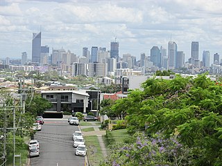
Gordon Park is a northern suburb in the City of Brisbane, Queensland, Australia. In the 2021 census, Gordon Park had a population of 4,390 people.

<span class="mw-page-title-main">Wooloowin, Queensland</span> Suburb of Brisbane, Queensland, Australia

Wooloowin is a suburb in the City of Brisbane, Queensland, Australia. In the 2021 census, Wooloowin had a population of 4,029 people.

<span class="mw-page-title-main">Alderley, Queensland</span> Suburb of Brisbane, Queensland, Australia

Alderley is a northern suburb in the City of Brisbane, Queensland, Australia. In the 2021 census, Alderley had a population of 6,748 people.

<span class="mw-page-title-main">Clayfield, Queensland</span> Suburb of Brisbane, Queensland, Australia

Clayfield is a suburb in the City of Brisbane, Queensland, Australia. In the 2021 census, Clayfield had a population of 10,897 people.

<span class="mw-page-title-main">Windsor, Queensland</span> Suburb of Brisbane, Queensland, Australia

Windsor is an inner northern suburb in the City of Brisbane, Queensland, Australia. In the 2021 census, Windsor had a population of 7,811 people.

<span class="mw-page-title-main">Kelvin Grove, Queensland</span> Suburb of Brisbane, Queensland, Australia

Kelvin Grove is an inner northern suburb in the City of Brisbane, Queensland, Australia. In the 2021 census, Kelvin Grove had a population of 7,909 people.

<span class="mw-page-title-main">Boondall, Queensland</span> Suburb of Brisbane, Australia

Boondall is a northern suburb in the City of Brisbane, Queensland, Australia. It was formerly known as Cabbage Tree Creek. In the 2021 census, Boondall had a population of 9,603 people.

<span class="mw-page-title-main">Greenslopes, Queensland</span> Suburb of Brisbane, Queensland, Australia

Greenslopes is a southern suburb in the City of Brisbane, Queensland, Australia. It is 6.0 kilometres (3.7 mi) by road south of the Brisbane CBD. In the 2021 census, Greenslopes had a population of 7,941 people.

<span class="mw-page-title-main">Brighton, Queensland</span> Suburb of Brisbane, Queensland, Australia

Brighton is a coastal northern suburb of the City of Brisbane, in the state of Queensland, in Australia. In the 2021 census, Brighton had a population of 9,664 people.

<span class="mw-page-title-main">Brisbane central business district</span> Suburb of Brisbane, Queensland, Australia

Brisbane City is the central suburb and central business district of Brisbane, the state capital of Queensland, Australia. It is also colloquially referred to as the "Brisbane CBD", "the city", or simply "town". The CBD is located on a point on the northern bank of the Brisbane River, historically known as Meanjin, Mianjin or Meeanjin in the local Yuggera dialect. The triangular-shaped peninsula is bounded by the median of the Brisbane River to the east, south and west. The point, known at its tip as Gardens Point, slopes upward to the north-west where the city is bounded by parkland and the inner city suburb of Spring Hill to the north. The CBD is bounded to the north-east by the suburb of Fortitude Valley. To the west the CBD is bounded by Milton, Petrie Terrace, and Kelvin Grove.

<span class="mw-page-title-main">Hillcrest, Queensland</span> Suburb of Logan City, Queensland, Australia

Hillcrest is a western suburb in the City of Logan, Queensland, Australia. In the 2021 census, Hillcrest had a population of 6,268 people.

<span class="mw-page-title-main">Hamilton, Queensland</span> Suburb of Brisbane, Queensland, Australia

Hamilton is an affluent riverside mixed-use suburb in the north-east of the City of Brisbane, Queensland, Australia. Hamilton is located along the north bank of the Brisbane River. In the 2021 census, Hamilton had a population of 8,922 people.

<span class="mw-page-title-main">Lota, Queensland</span> Suburb of Brisbane, Queensland, Australia

Lota is an eastern bayside suburb in the City of Brisbane, Queensland, Australia. In the 2021 census, Lota had a population of 3,518 people.

<span class="mw-page-title-main">Hemmant, Queensland</span> Suburb of Brisbane, Queensland, Australia

Hemmant is an eastern riverside suburb of the City of Brisbane, Queensland, Australia. In the 2021 census, Hemmant had a population of 2,886 people.

<span class="mw-page-title-main">Deagon, Queensland</span> Suburb of Brisbane, Queensland, Australia

Deagon is an outer northern suburb in the City of Brisbane, Queensland, Australia. In the 2021 census, Deagon had a population of 3,773 people.

<span class="mw-page-title-main">Ransome, Queensland</span> Suburb of Brisbane, Queensland, Australia

Ransome is an outer coastal suburb in the City of Brisbane, Queensland, Australia. In the 2021 census, Ransome had a population of 429 people.

<span class="mw-page-title-main">Elanora, Queensland</span> Suburb of Gold Coast, Queensland, Australia

Elanora is a suburb of the City of Gold Coast in Queensland, Australia. In the 2021 census, Elanora had a population of 12,539 people.

Meldale is a coastal rural locality in the City of Moreton Bay, Queensland, Australia. In the 2021 census, Meldale had a population of 230 people.

References

  1. 1 2 Nowland, Harrie (1926). "Streets of Brisbane". Sunday Mail (Brisbane). Retrieved 28 September 2013.
  2. Meston, Archibald. "Archibald Meston recalls Brisbane Creeks and Victoria Bridge". brisbanehistory.com. Archived from the original on 22 February 2011. Retrieved 28 September 2013.{{cite web}}: CS1 maint: unfit URL (link)
  3. e-CBD. "Maps of Brisbane". e-CBD. Retrieved 28 September 2013.
  4. My Student Guide. "Brisbane, Queensland". My Student Guide. Archived from the original on 13 September 2013. Retrieved 28 September 2013.
  5. Tony Moore (28 October 2008). "CBD road project faces blowout". Brisbane Times . Fairfax Digital . Retrieved 25 October 2009.
  6. Tony Moore (19 February 2009). "$6.8m Brisbane traffic plan up the Creek". Brisbane Times . Fairfax Digital . Retrieved 25 October 2009.
  7. "St Andrews Uniting Church (entry 600086)". Queensland Heritage Register . Queensland Heritage Council. Retrieved 19 June 2013.
  8. "National Australia Bank (entry 600153)". Queensland Heritage Register . Queensland Heritage Council. Retrieved 1 August 2014.
  9. "Eagle Street Fig Trees (entry 602440)". Queensland Heritage Register . Queensland Heritage Council. Retrieved 1 August 2014.

Commons-logo.svg Media related to Creek Street, Brisbane at Wikimedia Commons