
The Doomben railway line refers to the section of the Pinkenba railway line that currently operates a regular passenger service. Doomben, or "dumben', is the Indigenous Yuggera name for tree fern which was prolific in the area. The railway line branches from the North Coast line at Eagle Junction, extending 8 kilometres (5.0 mi) to Pinkenba, situated east-northeast of Brisbane, the state capital of Queensland, Australia. It is part of the Queensland Rail City network.

Ascot railway station is located on the Pinkenba line in Queensland, Australia. It serves the Brisbane suburb of Ascot adjacent to Eagle Farm Racecourse.

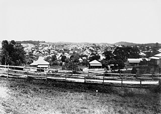
Ascot is a north-east suburb in the City of Brisbane, Queensland, Australia. In the 2016 census, Ascot had a population of 5,777 people.

Pinkenba is a town and coastal eastern suburb within the City of Brisbane, Queensland, Australia. In the 2016 census, Pinkenba had a population of 368 people.

Clayfield is an inner northern suburb in the City of Brisbane, Queensland, Australia. It is approximately 7 kilometres (4 mi) from the Brisbane CBD. Clayfield is bordered to the north by Nundah, to the east by Ascot and Hendra, to the west by Wooloowin and to the south by Albion.
Lutwyche is an inner-city residential suburb of the City of Brisbane, Queensland, Australia, located 5 kilometres (3.1 mi) north of the city's central business district. At the 2016 census the suburb recorded a population of 3,454.
Eagle Farm is an eastern industrial suburb of the City of Brisbane, Queensland, Australia. In the 2016 census, Eagle Farm had a population of 0 people.

Newstead is an inner northern riverside suburb of Brisbane, Queensland, Australia. At the 2016 census, it had a population of 2,193.

Hendra is a suburb of the City of Brisbane, Queensland, Australia. In the 2016 census, Hendra had a population of 4,625 people.

Bretts Wharf is a ferry terminal on the northern bank of the Brisbane River in the suburb of Hamilton in the City of Brisbane, Queensland, Australia. It serves patrons from nearby Racecourse Road and Portside Wharf, as well as visitors to Eagle Farm Racecourse and Doomben Racecourse in the Brisbane suburbs of Hamilton and Ascot. Bretts Wharf was the terminus for downstream CityCat services until Apollo Road reopened in February 2008. It is served by RiverCity Ferries' CityCat services.

Eagle Farm Racecourse is a heritage-listed horse racing venue in Brisbane, Queensland, Australia. It is located at the northern end of Racecourse Road in the suburb of Ascot, 7 kilometres (4.3 mi) from the Brisbane central business district.

Doomben Racecourse is a horse racing venue in Brisbane, Queensland, Australia. It is located in the suburb of Ascot, 7 kilometres north of the Brisbane central business district. The Doomben course neighbours another thoroughbred venue called the Eagle Farm Racecourse and can be accessed via car, train or bus. Together with Eagle Farm, these courses are considered the two major racecourses in South East Queensland, and can be seen sharing irrigation systems and some of Brisbane Racings feature events.

The Brisbane tramway network served the city of Brisbane, Australia, between 1885 and 1969. It ran on standard gauge track. The electric system was originally energised to 500 volts, and subsequently increased to 600 volts. All tramcars built in Brisbane up to 1938 had an open design. This proved so popular, especially on hot summer nights, that the trams were used as fundraisers and often chartered right up until the last service by social groups.

Hamilton is an affluent riverside mixed-use suburb in the north-east of the City of Brisbane, Queensland, Australia. Hamilton is located along the north bank of the Brisbane River. In the 2016 census, Hamilton had a population of 6,995 people.

Kingsford Smith Drive is a major road in Brisbane. The road was named after the aviator Charles Kingsford Smith. It connects the suburb of Pinkenba to the Brisbane central business district at the Breakfast Creek. Kingsford Smith Drive is one of the busiest roads in Brisbane, carrying an average of 61,773 vehicles per day between July and December 2014.
The Brisbane Racing Club (BRC) is an Australian horse racing organization based in Brisbane in the state of Queensland. The head office of the club is located at 230 Lancaster Road in Ascot.
John H. Buckeridge (1857–1934) was an English-born Australian architect, who built about sixty churches in Queensland and is also remembered for remodelling the interior of the Macquarie era church of St James', King Street, Sydney.

Eagle Farm Racecourse and Ascot Railway station is a heritage-listed pair of racecourse and railway station at 230 Lancaster Road, Ascot, City of Brisbane, Queensland, Australia. It was built from 1863 onwards. The racecourse is also known as Ascot Racecourse and Brisbane Racecourse, and Ascot railway station was previously known as Racecourse railway station. It was added to the Queensland Heritage Register on 25 June 2004.
Charles McLay was a Scottish-born architect in Queensland, Australia. Some of his works are now heritage-listed.

Hamilton State School is a heritage-listed state school at Oxford Street, Hamilton, City of Brisbane, Queensland, Australia. It was built in 1907. It was added to the Queensland Heritage Register on 30 November 2018.


