
The Bruce Highway is a major highway in Queensland, Australia. Commencing in the state capital, Brisbane, it passes through areas close to the eastern coast on its way to Cairns in Far North Queensland. The route is part of the Australian National Highway and also part of Highway 1, the longest highway route in Australia. Its length is approximately 1,679 kilometres (1,043 mi); it is entirely sealed with bitumen. The highway is named after a popular former Queensland and federal politician, Harry Bruce. Bruce was the state Minister for Works in the mid-1930s when the highway was named after him. The highway once passed through Brisbane, but was truncated at Bald Hills when the Gateway Motorway became National Highway 1 upon its opening in December 1986.
Southern Expressway is an 18.5 km (11.5 mi) freeway through the southern suburbs of Adelaide, South Australia. It is the southern part of the North–South Corridor which extends the full length of Adelaide and is being built to urban freeway standard. It is designated part of route M2.
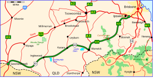
The Cunningham Highway is a 327-kilometre (203 mi) national highway located in south-eastern Queensland, Australia. The highway links the Darling Downs region with the urbanised outskirts of Ipswich via Cunninghams Gap.

The Pacific Motorway is a motorway in Australia between Brisbane, Queensland, and Brunswick Heads, New South Wales, through the New South Wales–Queensland border at Tweed Heads.
The Sunshine Motorway is a thirty-three kilometre Australian motorway on the Sunshine Coast region of Queensland, just north of Brisbane. It was initially a tolled motorway before these were removed in 1996 after excessive complaints regarding the need of a toll. It is part of State Route 70, which extends north a further 12.3 kilometres to Noosaville.
The Gateway Motorway is a major tolled motorway in Brisbane, Queensland, Australia which includes the Sir Leo Hielscher Bridges. The motorway is operated by toll road operator Transurban.

The Ipswich Motorway (M7) is a major road that connects Brisbane and Ipswich in South East Queensland, Australia. It commences at the junction of Ipswich Road and Granard Road and proceeds through to the M2 Logan Motorway interchange. It is then signed M2 until the junction of the Warrego Highway and the Cunningham Highway.

The M5 (Centenary Motorway) is a 43-kilometre (27 mi) motorway in the western suburbs of Brisbane, Australia.
The M1 in Queensland, Australia, is a major urban road corridor. It connects the Sunshine Coast hinterland to Tugun, near the New South Wales and Queensland border, via the following corridors:

Port of Brisbane Motorway is a motorway which connects the Port of Brisbane to the Gateway Motorway. Stage 1 was opened in December 2002. The motorway was built to take freight traffic off Lytton Road, with about 4,000 vehicles travelling to the Port of Brisbane in 2002. Stage 1 cost A$196 million and was finished six months ahead of schedule and A$20 million under budget. The Port of Brisbane Motorway holds the M4 motorway designation.
The road transport in Brisbane, Australia, consists of a network of highways, freeways and motorways. Some motorways have tolls applied.
Gympie Road is a major road in the northern suburbs of Brisbane, Queensland, Australia. The road forms part of the main road route from the Brisbane Central Business District (CBD) to the northern suburbs, Sunshine Coast and east coast of Queensland.

Old Cleveland Road is a major road in Brisbane, Queensland. It runs 19.3 kilometres (12.0 mi) from Stones Corner to Capalaba in Brisbane, with most of the route signed as State Route 22. Sections of the road are also part of State Routes 30, 54, and 55. The road is the main route from inner Brisbane to Capalaba and Cleveland since New Cleveland Road only links Tingalpa with Capalaba.
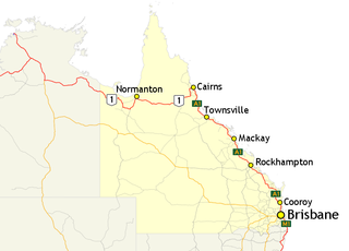
In Queensland, Highway 1 is a 2,964-kilometre (1,842 mi) long route that crosses the state, from the Northern Territory (NT) border near Wollogorang to Cairns, and then travels along the coastline to the New South Wales (NSW) border near Coolangatta. Highway 1 continues around the rest of Australia, joining all mainland state capitals, and connecting major centres in Tasmania. All roads within the Highway 1 system are allocated a road route numbered 1, M1, A1, or B1, depending on the state route numbering system. In Queensland, the highway is designated as National Route 1 from the NT border to Cairns, Route A1 from Cairns to Kybong, and then Route M1 down to the NSW border.
Maroochydore Road is a major arterial road on the Sunshine Coast, Queensland that connects the major town/urban centre of Maroochydore with the Bruce Highway.
Glass House Mountains Road is a continuous 30.4-kilometre (18.9 mi) road route in the Moreton Bay and Sunshine Coast local government areas of Queensland, Australia. Part of it is designated as part of State Route 6. It is a state-controlled road, part regional and part district.
Caloundra Road is a continuous 9.3-kilometre (5.8 mi) road route in the Sunshine Coast local government area of Queensland, Australia. Most of it is designated as part of State Route 6. It is a state-controlled district road, part of which is rated as a local road of regional significance (LRRS).
Brisbane–Woodford Road is the official name for a continuous 60.5-kilometre (37.6 mi) road route in the Moreton Bay local government area of Queensland, Australia. It is designated as part of State Route 58. It is a state-controlled road part regional and part district, rated as a local road of regional significance (LRRS).
There are two roads named South Pine Road to the north of Brisbane in Queensland, Australia. They are two separate roads rather than a disconnected single road. It is likely that the duplicate naming is the result of actions by two former local authorities, the Shire of Enoggera and the Shire of Pine Rivers.