
The Bruce Highway is a major highway in Queensland, Australia. Commencing in the state capital, Brisbane, it passes through areas close to the eastern coast on its way to Cairns in Far North Queensland. The route is part of the Australian National Highway and also part of Highway 1, the longest highway route in Australia. Its length is approximately 1,679 kilometres (1,043 mi); it is entirely sealed with bitumen. The highway is named after a popular former Queensland and federal politician, Harry Bruce. Bruce was the state Minister for Works in the mid-1930s when the highway was named after him. The highway once passed through Brisbane, but was truncated at Bald Hills when the Gateway Motorway became National Highway 1 upon its opening in December 1986.
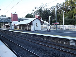
Petrie railway station is located on the North Coast line in Queensland, Australia. It serves the suburb of Petrie in the City of Moreton Bay. It opened as North Pine railway station in 1888 after the nearby North Pine River and was renamed Petrie railway station in 1911.

Aspley is a suburb in the City of Brisbane, Queensland, Australia. In the 2021 census, Aspley had a population of 12,871 people.

Chermside is a suburb in the City of Brisbane, Queensland, Australia. The suburb is situated 9.8 kilometres (6.1 mi) by road north of the Brisbane CBD. It is home to a large Westfield shopping centre. In the 2021 census, Chermside had a population of 11,426 people.

The Shire of Pine Rivers was a local government area about 20 kilometres (12 mi) north of Brisbane in the Moreton Bay region of South East Queensland, Australia. The shire covered an area of 771 square kilometres (297.7 sq mi), and existed as a local government entity from 1888 until 2008, when it amalgamated with councils further north and east to form the Moreton Bay Region, renamed in July 2023 as the City of Moreton Bay.
The Northern Busway is a bus-only road running north from the Brisbane central business district to the Royal Brisbane & Women's Hospital in Queensland, Australia. The first section of the busway opened on 23 February 2004 with one station at QUT Kelvin Grove. In December 2005, Normanby and Herston stations opened.
Petrie is a suburb in the City of Moreton Bay, Queensland, Australia. In the 2021 census, Petrie had a population of 8,722 people.

Lutwyche is a northern suburb in the City of Brisbane, Queensland, Australia. In the 2021 census, Lutwyche had a population of 4,610 people.

Kedron is a northern suburb in the City of Brisbane, Queensland, Australia. It is home to the Queensland Fire and Emergency Services headquarters. In the 2021 census, Kedron had a population of 9,907 people.

Strathpine is a suburb in the City of Moreton Bay, Queensland, Australia. It is home to the Pine Rivers District offices of the City of Moreton Bay, as well as many businesses, administrative, and local, state and federal government offices. The area is home to Strathpine Centre, a medium-sized urban shopping centre, built by Westfield.

Kallangur is a suburb in the City of Moreton Bay, Queensland, Australia. In the 2021 census, Kallangur had a population of 21,761 people.
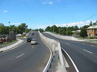
The M1 in Queensland, Australia, is a major urban road corridor. It connects the Sunshine Coast hinterland to Tugun, near the New South Wales and Queensland border, via the following corridors:
Westfield North Lakes is a shopping centre in North Lakes on the northern outskirts of Brisbane. The centre first opened in on 7 August 2003 and initially included around 80 stores including Target and Coles. In early 2007, construction began on a major extension that was set to bring the total number of stores in the centre to over 200. The extension was opened to the public in October of the same year, including Big W and Woolworths stores and a food court which replaced the old one that was demolished due to the expansion. In May 2008, the centre's 2-level Myer store was opened, which replaced the Myer store in Strathpine Centre that closed in 2007. IKEA opened their second Queensland store at Westfield North Lakes in November 2016. Stage 3 also has 60 additional stores, including Kmart, Rebel Sport, JB HI-FI and Cotton On.

Anzac Avenue is a heritage-listed major arterial road lined with trees in the City of Moreton Bay, Queensland, Australia. It runs 17.8 kilometres (11.1 mi) from Petrie to Redcliffe, with most of the route signed as state route 71. The route was formerly the main route to the Redcliffe peninsula, until the Hornibrook Bridge was opened in 1935.

The Redcliffe Peninsula line is a 12 km (7.5 mi) stretch of heavy gauge dual-track railway between Petrie and Kippa-Ring on the Redcliffe peninsula in Queensland, Australia. The new line is part of Queensland Rail's City suburban network, branching from the North Coast line. It starts 200 metres (656 ft) north of Petrie railway station, extending from.

Murrumba Homestead Grounds is a heritage-listed site at 38 Armstrong Street, Petrie, City of Moreton Bay, Queensland, Australia. It was added to the Queensland Heritage Register on 16 February 2009.
Brisbane–Woodford Road is the official name for a continuous 60.5-kilometre (37.6 mi) road route in the Moreton Bay local government area of Queensland, Australia. It is designated as part of State Route 58. It is a state-controlled road part regional and part district, rated as a local road of regional significance (LRRS).
Redcliffe Peninsula road network is a group of roads that provide access to the Redcliffe Peninsula in Queensland, Australia, and enable travel between the contained communities. The area serviced by the network includes the localities of Clontarf, Kippa-Ring, Margate, Newport, Redcliffe, Rothwell, Scarborough and Woody Point.
There are two roads named South Pine Road to the north of Brisbane in Queensland, Australia. They are two separate roads rather than a disconnected single road. It is likely that the duplicate naming is the result of actions by two former local authorities, the Shire of Enoggera and the Shire of Pine Rivers.


