Wooloowin, Queensland

Last updated

Wooloowin
Brisbane,  Queensland
Wooloowin State School, 1914.JPG
Wooloowin State School, 2011
Australia Queensland location map.svg
Red pog.svg
Wooloowin
Coordinates 27°25′11″S153°02′30″E / 27.4197°S 153.0416°E / -27.4197; 153.0416 (Wooloowin (centre of suburb))
Population4,029 (2021 census) [1]
 • Density3,660/km2 (9,500/sq mi)
Postcode(s) 4030
Area1.1 km2 (0.4 sq mi)
Time zone AEST (UTC+10:00)
Location6.1 km (4 mi) NNE of Brisbane CBD
LGA(s) City of Brisbane
(Hamilton Ward) [2]
State electorate(s) Clayfield
Federal division(s) Brisbane
Suburbs around Wooloowin:
Kedron Kalinga Kalinga
Lutwyche Wooloowin Clayfield
Lutwyche Albion Clayfield

Wooloowin ( /ˈwʊləwən/ WUU-lə-wən) is a suburb in the City of Brisbane, Queensland, Australia. [3] In the 2021 census, Wooloowin had a population of 4,029 people. [1]

Contents

Geography

Wooloowin is an inner-north suburb of Brisbane, Australia located approximately 5–6 km north of the city's central business district.[ citation needed ]

History

The origin of the suburb's name has been attributed to either the local Indigenous Australian term for a pigeon or the term for a species of fish. [3] It was the home of Brisbane's first Resident Judge, Alfred Lutwyche, who lived in Kedron Lodge. [4]

Holy Cross Primary School opened in 1889. [5]

A stump-capping ceremony for Wooloowin Methodist Church was held on Saturday 30 November 1901. The site was on Old Sandgate Road at the junction with Bayview Terrace (now 170 Bonney Avenue). [6] [7] While the church was being built, it was destroyed by a cyclone in January 1901. [8] [9] The church was re-built and opened on Sunday 13 April 1902 by Reverend Robert Stewart, President of the Queensland Methodist Conference. [10] In 1975 Wooloowin Methodist Church amalgamated with Eagle Junction Congregational Church (at 211 Bonney Avenue, Clayfield) to form the Bonney Avenue Cooperative Parish. Following the amalgamation that created the Uniting Church in Australia in 1977, it was renamed Clayfield Uniting Church and decided to operate exclusively from the site of the Wooloowin Methodist Church. The Eagle Junction Congregational Church and its adjacent hall at 5 Norman Parade into private ownership; [11] both buildings still exist and are listed on the Brisbane Heritage Register. [12] [13] The foundation stone of the current Clayfield Uniting Church building was laid on Sunday 2 March 1986 by Reverend Leslie Tiplin Vickery and it was opened and dedicated on 5 April 1987 by Reverend Barry Dangerfield. [11]

Wooloowin State School opened on 15 September 1914. [5]

Kedron State High School opened on 23 January 1956. [5]

Kalinga was a residential district within Wooloowin. On 16 October 2015, Kalinga was officially gazetted as a suburb, having been excised from Wooloowin. [14]

Demographics

In the 2011 census, Wooloowin had a population of 5,942 people. [15]

In the 2016 census, Wooloowin had a population of 3,938 people. [16]

In the 2021 census, Wooloowin had a population of 4,029 people. [1]

Heritage listings

Kedron Lodge, original residence of Justice Lutwyche. Kedron Lodge Queensland.gjm.JPG
Kedron Lodge, original residence of Justice Lutwyche.

Wooloowin has a number of heritage-listed sites, including:

Heritage sites formerly in Wooloowin but now in Kalinga:

Education

Wooloowin State School is a government primary (Prep-6) school for boys and girls at 663 Lutwyche Road ( 27°25′02″S153°02′12″E / 27.4173°S 153.0366°E / -27.4173; 153.0366 (Wooloowin State School) ). [44] [45] In 2018, the school had an enrolment of 325 students with 27 teachers (22 full-time equivalent) and 20 non-teaching staff (9 full-time equivalent). [46]

Holy Cross School is a Catholic primary (Prep-6) school for boys and girls at 40 Morris Street ( 27°25′26″S153°02′23″E / 27.4240°S 153.0396°E / -27.4240; 153.0396 (Holy Cross School) ). [44] [47] In 2018, the school had an enrolment of 206 students with 20 teachers (15 full-time equivalent) and 13 non-teaching staff (8 full-time equivalent). [46]

There is no secondary school in Wooloowin but Kedron State High School is just beyond on boundary of Wooloowin and Kedron. [48]

Amenities

Despite its name, Clayfield Uniting Church is at 170 Bonney Avenue in Wooloowin ( 27°25′07″S153°02′51″E / 27.4186°S 153.0474°E / -27.4186; 153.0474 (Clayfield Uniting Church) ). [49] [11]

A number of male and female sporting groups use Shaw Park including Norths Rugby Club Northern Suburbs District Cricket Club and Wilston Norths Junior Cricket Club. [50]

Transport

The suburb is serviced by Brisbane City Council buses (Route 721) and contains two train stations, Eagle Junction and Wooloowin. Several Queensland government institutions are located in this suburb, including Kedron State High School and the State of Queensland's State Emergency Services headquarters.[ citation needed ]

Related Research Articles

<span class="mw-page-title-main">Albion, Queensland</span> Suburb of Brisbane, Queensland, Australia

Albion is an inner north-eastern suburb in the City of Brisbane, Queensland, Australia. In the 2021 census, Albion had a population of 3,446 people.

<span class="mw-page-title-main">Aspley, Queensland</span> Suburb of Brisbane, Queensland, Australia

Aspley is a suburb in the City of Brisbane, Queensland, Australia. In the 2021 census, Aspley had a population of 12,871 people.

<span class="mw-page-title-main">Chermside, Queensland</span> Suburb of Queensland, Australia

Chermside is a suburb in the City of Brisbane, Queensland, Australia. The suburb is situated 9.8 kilometres (6.1 mi) by road north of the Brisbane CBD. It is home to a large Westfield shopping centre. In the 2021 census, Chermside had a population of 11,426 people.

<span class="mw-page-title-main">Gordon Park, Queensland</span> Suburb of Brisbane, Queensland, Australia

Gordon Park is a northern suburb in the City of Brisbane, Queensland, Australia. In the 2021 census, Gordon Park had a population of 4,390 people.

<span class="mw-page-title-main">Clayfield, Queensland</span> Suburb of Brisbane, Queensland, Australia

Clayfield is a suburb in the City of Brisbane, Queensland, Australia. In the 2021 census, Clayfield had a population of 10,897 people.

<span class="mw-page-title-main">Alfred Lutwyche</span> Australian politician

Justice Alfred James Peter Lutwyche, Queen's Counsel was the first judge of the Supreme Court Bench of Queensland.

<span class="mw-page-title-main">Lutwyche, Queensland</span> Suburb of Brisbane, Queensland, Australia

Lutwyche is a northern suburb in the City of Brisbane, Queensland, Australia. In the 2021 census, Lutwyche had a population of 4,610 people.

<span class="mw-page-title-main">Kedron, Queensland</span> Suburb of Brisbane, Queensland, Australia

Kedron is a northern suburb in the City of Brisbane, Queensland, Australia. It is home to the Queensland Fire and Emergency Services headquarters. In the 2021 census, Kedron had a population of 9,907 people.

<span class="mw-page-title-main">Windsor, Queensland</span> Suburb of Brisbane, Queensland, Australia

Windsor is an inner northern suburb in the City of Brisbane, Queensland, Australia. In the 2021 census, Windsor had a population of 7,811 people.

<span class="mw-page-title-main">Nundah, Queensland</span> Suburb of Brisbane, Queensland, Australia

Nundah is an inner suburb in the City of Brisbane, Queensland, Australia. It contains the neighbourhood of Toombul. In the 2021 census, Nundah had a population of 13,098 people.

<span class="mw-page-title-main">Wavell Heights, Queensland</span> Suburb of Brisbane, Queensland, Australia

Wavell Heights is a suburb in the City of Brisbane, Queensland, Australia. In the 2021 census, Wavell Heights had a population of 10,336 people.

<span class="mw-page-title-main">Stafford, Queensland</span> Suburb of Brisbane, Queensland, Australia

Stafford is a northern suburb in the City of Brisbane, Queensland, Australia. In the 2021 census, Stafford had a population of 6,978 people.

<span class="mw-page-title-main">Kalinga, Queensland</span> Suburb of Brisbane, Queensland, Australia

Kalinga is a suburb in the City of Brisbane, Queensland, Australia. In the 2016 census, Kalinga had a population of 2,126 people.

<span class="mw-page-title-main">Hendra, Queensland</span> Suburb of Brisbane, Queensland, Australia

Hendra is a suburb of the City of Brisbane, Queensland, Australia. In the 2021 census, Hendra had a population of 4,914 people.

Newmarket is a north-west suburb in the City of Brisbane, Queensland, Australia. In the 2021 census, Newmarket had a population of 5,083 people.

<span class="mw-page-title-main">Kalinga Park</span> Historic site in Queensland, Australia

Kalinga Park is a heritage-listed park at 100 Bertha Street, Kalinga, City of Brisbane, Queensland, Australia. The eastern section of the park is in neighbouring Clayfield. It is also known as Anzac Memorial Park. It was added to the Queensland Heritage Register on 3 July 2007.

<span class="mw-page-title-main">Wilston, Queensland</span> Suburb of Brisbane, Australia

Wilston is a northern suburb in the City of Brisbane, Queensland, Australia. In the 2021 census, Wilston had a population of 4,110 people.

<span class="mw-page-title-main">Grange, Queensland</span> Suburb of Brisbane, Queensland, Australia

Grange is a northern suburb in the City of Brisbane, Queensland, Australia. In the 2021 census, Grange had a population of 4,615 people.

<span class="mw-page-title-main">Kedron Brook</span> River in Queensland, Australia

The Kedron Brook is a creek that flows through the northern suburbs of Brisbane in the south-east region of Queensland, Australia.

<span class="mw-page-title-main">Kedron Lodge</span> Historic site in Queensland, Australia

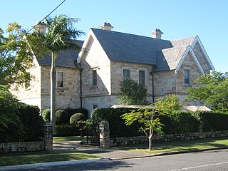
Kedron Lodge is a heritage-listed villa at 123 Nelson Street, Kalinga, City of Brisbane, Queensland, Australia. It was designed by architect Christopher Porter and was built from 1860 to the early 1900s by John Petrie. It was added to the Queensland Heritage Register on 21 October 1992.

References

  1. 1 2 3 Australian Bureau of Statistics (28 June 2022). "Wooloowin (SAL)". 2021 Census QuickStats. Retrieved 28 February 2023. OOjs UI icon edit-ltr-progressive.svg
  2. "Hamilton Ward". Brisbane City Council. Archived from the original on 12 March 2017. Retrieved 12 March 2017.
  3. 1 2 "Wooloowin – suburb in City of Brisbane (entry 50320)". Queensland Place Names. Queensland Government . Retrieved 26 December 2020.
  4. 1 2 "Kedron Lodge (entry 600238)". Queensland Heritage Register . Queensland Heritage Council. Retrieved 19 June 2013.
  5. 1 2 3 Queensland Family History Society (2010), Queensland schools past and present (Version 1.01 ed.), Queensland Family History Society, ISBN   978-1-921171-26-0
  6. "Wooloowin Methodist Church". The Telegraph . No. 9, 057. Queensland, Australia. 29 November 1901. p. 3 (SECOND EDITION). Archived from the original on 11 September 2021. Retrieved 12 September 2021 via National Library of Australia.
  7. "Eagle Junction Methodists". The Telegraph . No. 9, 059. Queensland, Australia. 2 December 1901. p. 2. Archived from the original on 11 September 2021. Retrieved 12 September 2021 via National Library of Australia.
  8. "LUTWYCHE AND WOOLOOWIN". The Telegraph . No. 9, 096. Queensland, Australia. 15 January 1902. p. 5. Archived from the original on 11 September 2021. Retrieved 12 September 2021 via National Library of Australia.
  9. "IN AND AROUND BRISBANE". The Brisbane Courier . Vol. LVIII, no. 13, 732. Queensland, Australia. 16 January 1902. p. 6. Archived from the original on 11 September 2021. Retrieved 12 September 2021 via National Library of Australia.
  10. "Wooloowin Methodists". The Telegraph . No. 9, 172. Queensland, Australia. 14 April 1902. p. 3 (SECOND EDITION). Archived from the original on 11 September 2021. Retrieved 12 September 2021 via National Library of Australia.
  11. 1 2 3 "Clayfield Uniting Church". Churches Australia. Archived from the original on 11 September 2021. Retrieved 11 September 2021.
  12. "Eagle Junction Uniting Church - Former". Churches Australia. Archived from the original on 11 September 2021. Retrieved 11 September 2021.
  13. "Congregational Church & Hall (former)". Brisbane Heritage Register. Brisbane City Council . Retrieved 12 September 2021.
  14. "Kalinga – suburb in City of Brisbane (entry 49667)". Queensland Place Names. Queensland Government . Retrieved 10 October 2017.
  15. Australian Bureau of Statistics (31 October 2012). "Wooloowin (State Suburb)". 2011 Census QuickStats. Retrieved 16 February 2014. OOjs UI icon edit-ltr-progressive.svg
  16. Australian Bureau of Statistics (27 June 2017). "Wooloowin (SSC)". 2016 Census QuickStats. Retrieved 20 October 2018. OOjs UI icon edit-ltr-progressive.svg
  17. "San Michelle". Brisbane Heritage Register. Brisbane City Council . Retrieved 9 March 2020.
  18. "76 Adamson Street, Wooloowin". Brisbane Heritage Register. Brisbane City Council . Retrieved 9 March 2020.
  19. "D Juan". Brisbane Heritage Register. Brisbane City Council . Retrieved 9 March 2020.
  20. "Shop". Brisbane Heritage Register. Brisbane City Council . Retrieved 9 March 2020.
  21. "Albion Fire Station (former) (entry 602246)". Queensland Heritage Register . Queensland Heritage Council. Retrieved 19 June 2013.
  22. "Holy Cross Laundry (entry 600359)". Queensland Heritage Register . Queensland Heritage Council. Retrieved 19 June 2013.
  23. "Sisters of Mercy Convent". Brisbane Heritage Register. Brisbane City Council . Retrieved 9 March 2020.
  24. "Holy Cross Catholic Church (former)". Brisbane Heritage Register. Brisbane City Council . Retrieved 9 March 2020.
  25. "Shop & Residence". Brisbane Heritage Register. Brisbane City Council . Retrieved 9 March 2020.
  26. "20 Inwood Street, Wooloowin". Brisbane Heritage Register. Brisbane City Council . Retrieved 9 March 2020.
  27. "22 Inwood Street, Wooloowin". Brisbane Heritage Register. Brisbane City Council . Retrieved 9 March 2020.
  28. "31 Kedron Street, Wooloowin". Brisbane Heritage Register. Brisbane City Council . Retrieved 9 March 2020.
  29. "Brisbane City Council Tramways Substation No. 8 (former) (entry 602411)". Queensland Heritage Register . Queensland Heritage Council. Retrieved 19 June 2013.
  30. "Clytha". Brisbane Heritage Register. Brisbane City Council . Retrieved 9 March 2020.
  31. "Mornington". Brisbane Heritage Register. Brisbane City Council . Retrieved 9 March 2020.
  32. "Wooloowin State School (entry 601565)". Queensland Heritage Register . Queensland Heritage Council. Retrieved 1 August 2014.
  33. "33 McIntyre Street, Wooloowin". Brisbane Heritage Register. Brisbane City Council . Retrieved 9 March 2020.
  34. "Camden". Brisbane Heritage Register. Brisbane City Council . Retrieved 9 March 2020.
  35. "Thurso". Brisbane Heritage Register. Brisbane City Council . Retrieved 9 March 2020.
  36. "Nelley". Brisbane Heritage Register. Brisbane City Council . Retrieved 9 March 2020.
  37. "Witherby". Brisbane Heritage Register. Brisbane City Council . Retrieved 9 March 2020.
  38. "Eboracum". Brisbane Heritage Register. Brisbane City Council . Retrieved 9 March 2020.
  39. "63 Rose Street, Wooloowin". Brisbane Heritage Register. Brisbane City Council . Retrieved 9 March 2020.
  40. "23 Stopford Street, Wooloowin". Brisbane Heritage Register. Brisbane City Council . Retrieved 9 March 2020.
  41. "52 View Street, Wooloowin". Brisbane Heritage Register. Brisbane City Council . Retrieved 9 March 2020.
  42. "17 Wooloowin Avenue Wooloowin". Brisbane Heritage Register. Brisbane City Council . Retrieved 9 March 2020.
  43. "Kalinga Park (entry 602584)". Queensland Heritage Register . Queensland Heritage Council. Retrieved 19 June 2013.
  44. 1 2 "State and non-state school details". Queensland Government. 9 July 2018. Archived from the original on 21 November 2018. Retrieved 21 November 2018.
  45. "Wooloowin State School". Wooloowin State School. 21 February 2020. Archived from the original on 16 March 2021. Retrieved 25 May 2022.
  46. 1 2 "ACARA School Profile 2018". Australian Curriculum, Assessment and Reporting Authority. Archived from the original on 27 August 2020. Retrieved 28 January 2020.
  47. "Welcome to Holy Cross Wooloowin". Holy Cross School Wooloowin. Archived from the original on 6 March 2022. Retrieved 25 May 2022.
  48. "Queensland Globe". State of Queensland . Retrieved 24 March 2021.
  49. "Find a Church". Uniting Church in Australia, Queensland Synod. Archived from the original on 24 October 2020. Retrieved 22 November 2020.
  50. "Northern Suburbs District Cricket Club". northernsdcc.qld.cricket.com.au. Archived from the original on 4 March 2020. Retrieved 13 April 2020.