Newstead, Queensland

Last updated

Newstead
Brisbane,  Queensland
Wyatt Street, Newstead, Queensland, 2021.jpg
Wyatt Street, Newstead
Australia Queensland location map.svg
Red pog.svg
Newstead
Newstead, Queensland
Coordinates 27°27′13″S153°02′39″E / 27.4536°S 153.0442°E / -27.4536; 153.0442 (Newstead (centre of suburb))
Population7,496 (2021 census) [1]
 • Density8,300/km2 (21,600/sq mi)
Postcode(s) 4006
Area0.9 km2 (0.3 sq mi)
Time zone AEST (UTC+10:00)
Location3.3 km (2 mi) NE of Brisbane GPO
LGA(s) City of Brisbane
(Central Ward) [2]
State electorate(s) McConnel
Federal division(s) Brisbane
Suburbs around Newstead:
Bowen Hills Albion Hamilton
Bowen Hills Newstead Bulimba
Fortitude Valley Fortitude Valley Teneriffe

Newstead is an inner northern riverside suburb of Brisbane, Queensland, Australia. [3] At the 2021 census, it had a population of 7,496. [1]

Contents

Geography

Newstead is 3.3 kilometres (2.1 mi) north-east of Brisbane central business district, bounded by Breakfast Creek to the north and the Brisbane River to the east. [4]

The northern and western parts of the suburb, centred on Breakfast Creek Road, is predominantly commercial, with the remainder, particularly near the river, becoming increasingly residential. [5]

History

Rotunda in Newstead Park looking over the Brisbane River Rotunda in Newstead Park, Queensland 04.jpg
Rotunda in Newstead Park looking over the Brisbane River

The suburb takes its name from Newstead House, built and named in 1846 by pioneer grazier Patrick Leslie, which in turn takes its name from Newstead Abbey in Nottinghamshire, England. [3]

The suburb's present role as an up-market residential suburb belies its industrial past. Timber yards, asbestos works, wharves and woolstores once dominated the eastern side of the suburb. The tall iron structure of the No. 2 gasholder on Skyring Terrace is a remnant of the Newstead Gasworks ( 27°27′02″S153°02′36″E / 27.4505°S 153.0434°E / -27.4505; 153.0434 (Newstead Gasworks) ), which was established in 1887 as Brisbane's second gas works. The structure, however, was originally located at the Petrie Bight gasworks, where it was erected in 1873.

The suburb was served by first horse drawn trams from 1885. From 1897 electric trams ran along Commercial Road (until December 1962) and along Ann and Wickham Streets until April 1969. Light Street tram and bus depot was located in the suburb. It opened as a tram depot in 1885, saw its last trams in December 1968 and finally closed as a bus depot in the mid 1990s, making it one of Queensland's longest continually operating industrial sites. All traces of the depot and its heritage have been obliterated and the site redeveloped, although a remnant of its trackwork – a unique three way set of points – has been preserved at the Brisbane Tramway Museum.

In 1888 the Booroodabin Bowls Club was established, making it the oldest bowls club still operating in Queensland. [6] At that time, the club was within the local government area of Booroodabin Division, which was established in 1879 and amalgamated into the Town of Brisbane in 1903. The club's name presumably reflects the local government area. The name Booroodabin is an Aboriginal word meaning place of the she-oaks . [7]

Breakfast Creek State School opened on 7 July 1890 and closed on 11 August 1961. [8] It was on the western side of Agnes Street ( 27°26′25″S153°02′48″E / 27.4404°S 153.0468°E / -27.4404; 153.0468 (Breakfast Creek State School (former)) , now in Albion). [9] [10] Following the closure of the school, the Fortitude Valley Opportunity School relocated into the buildings, becoming Newstead Opportunity School. Later it was renamed Newstead Special School ( 27°26′25″S153°02′49″E / 27.4404°S 153.0469°E / -27.4404; 153.0469 (Newstead Special School (former)) ). It closed in 1996. [8] [11]

The suburb was served by the Bulimba Branch railway line, which branched off the main north coast line at Bowen Hills and descended towards the river and Breakfast Creek Road, crossing it to reach the industry, wool stores and wharves along the river. [12] The line opened on 16 December 1897 and closed on 31 March 1990. Some remnants of the rail line have been preserved in the wool stores precinct. The name Bulimba reflects historic use of this name for both sides of the Bulimba Reach of the Brisbane River, but today it refers only to the suburb on the south side of the reach. [13] [14]

Newstead Park contains the Australian American Memorial ( 27°26′32″S153°02′50″E / 27.4423°S 153.0473°E / -27.4423; 153.0473 (Australian American Memorial) ) which commemorates the United States of America's contribution to defending Australia during World War II, when General Douglas MacArthur based his headquarters in Brisbane. The foundation stone of the memorial was laid on 3 May 1951 during Coral Sea week (the Battle of the Coral Sea was fought from 4 to 8 May 1942). The completed memorial was unveiled on 3 May 1952 by Sir John Lavarack, then the Governor of Queensland. [15]

Demographics

Historical population
YearPop.±%
2006415    
2011836+101.4%
20162,193+162.3%
20217,496+241.8%

In the 2011 census, Newstead had a population of 836 people, 49.8% female and 50.2% male. [16] The median age of the Newstead population was 36 years of age, 1 year below the Australian median. Children aged under 15 years made up 4.2% of the population and people aged 65 years and over made up 16.5% of the population. 67.8% of people living in Newstead were born in Australia, compared to the national average of 69.8%. The other top responses for country of birth were England 4.4%, New Zealand 3.8%, United States of America 1.9%, South Africa 1.3%, Saudi Arabia 1.1%. 81.6% of people spoke only English at home; the next most popular languages were 1.4% Cantonese, 1.4% Arabic, 0.8% Persian (excluding Dari), 0.8% Italian, 0.8% Spanish. The most common responses for religion in Newstead were No Religion 27.9%, Catholic 25.4%, Anglican 18.4%, Uniting Church 6.6%, and Presbyterian and Reformed 3.1%. [16]

In the 2016 census, Newstead had a population of 2,193 people, 49.4% identifying as male and 50.6% identifying as female. [17] The median age of was 35 years of age, two years below the Queensland median and three years below the Australian median. 55.4% of residents were born in Australia, around 15% less than Queensland and around 11% less than all Australia. 26.4% of residents had tertiary or university institution education, versus 14.8% for Queensland and 16.1% for all Australia. ~56% of residents indicated "No Religion" or "not stated" versus ~39% for both Queensland and Australia populations. ~76% of residents (over 15 years old and in work force) were working full-time, compared with ~58% for both Queensland and Australia populations. [17]

At the 2021 census, Newstead had a population of 7,496 people. [1]

Heritage listings

Newstead has a number of heritage-listed sites, including:

Education

There are no schools in Newstead. The nearest primary schools are New Farm State School in New Farm and Ascot State School in Ascot. The nearest secondary school is Fortitude Valley State Secondary College in Fortitude Valley, but, having opened in 2020 with Year 7 only, will not offer all years of secondary schooling until 2025. [32] Other years of secondary schooling are available at Kelvin Grove State College in Kelvin Grove and Kedron State High School in Kedron. [5]

Amenities

Gasworks Newstead precinct Gasworks Newstead, Brisbane 2019, 01.jpg
Gasworks Newstead precinct

Booroodabin Bowls Club (nicknamed "The Boo") is on the corner of Breakfast Creek Road and Edmonstone Street ( 27°26′41″S153°02′33″E / 27.4448°S 153.0426°E / -27.4448; 153.0426 (Booroodabin Bowls Club) ). [5] The Gasworks Newstead retail precinct includes restaurants, cafes, shops, a supermarket, and a public plaza inside the old gas holder of the heritage-listed Newstead Gasworks.

Pride of the suburb is Newstead House, Brisbane's oldest existing home, built for pioneer Darling Downs squatter Patrick Leslie in 1846. It is set in superb grounds overlooking the mouth of the creek and is within easy walking distance of the famed Breakfast Creek Hotel – a flamboyant Victorian structure which has been described as 'the very soul of Brisbane'. Newstead House's glory days came during the time of the residence of Captain John Clements Wickham, the official resident and magistrate of the Moreton Bay settlement and a noted and gracious host. Wickham had previously been Commander of HMS Beagle and sailed with Charles Darwin. While an admission fee must be paid to visit the house, the gardens (now Newstead Park) are a public park. [23]

Transport

Transport for Brisbane serves the suburb by bus. A cross river ferry, operated by RiverCity Ferries, links the suburb to Bulimba from the nearby Teneriffe ferry wharf. The suburb is also linked to the city by "CityCat" catamaran ferry service.

Related Research Articles

<span class="mw-page-title-main">Albion, Queensland</span> Suburb of Brisbane, Queensland, Australia

Albion is an inner north-eastern suburb in the City of Brisbane, Queensland, Australia. In the 2016 census, Albion had a population of 2,296 people.

<span class="mw-page-title-main">Coorparoo, Queensland</span> Suburb of Brisbane, Queensland, Australia

Coorparoo is a suburb in the inner City of Brisbane, Queensland, Australia. In the 2021 census, Coorparoo had a population of 18,132 people.

<span class="mw-page-title-main">Ascot, Queensland</span> Suburb of Brisbane, Queensland, Australia

Ascot is a north-east suburb in the City of Brisbane, Queensland, Australia. In the 2016 census, Ascot had a population of 5,777 people.

<span class="mw-page-title-main">Bulimba Creek</span> River in Queensland, Australia

Bulimba Creek, originally known as Doboy Creek or Doughboy Creek, is a perennial stream that is a tributary of the Brisbane River, located in suburban Brisbane in the South East region of Queensland, Australia.

<span class="mw-page-title-main">Tingalpa, Queensland</span> Suburb of Brisbane, Queensland, Australia

Tingalpa is a suburb in the City of Brisbane, Queensland, Australia. In the 2016 census, Tingalpa had a population of 8,290 people.

<span class="mw-page-title-main">Carina, Queensland</span> Suburb of Brisbane, Queensland, Australia

Carina is a suburb in the City of Brisbane, Queensland, Australia. In the 2016 census, Carina had a population of 11,019 people.

<span class="mw-page-title-main">New Farm, Queensland</span> Suburb of Brisbane, Queensland, Australia

New Farm is an inner northern riverside suburb in the City of Brisbane, Queensland, Australia. In the 2021 census, New Farm had a population of 12,454 people.

<span class="mw-page-title-main">Murarrie, Queensland</span> Suburb of Brisbane, Queensland, Australia

Murarrie is an eastern riverside mixed-use suburb in the City of Brisbane, Queensland, Australia. Queensport is a neighbourhood within Murarrie. Gibson Island is a neighbourhood within Murarrie and, despite its name, is no longer an island. In the 2021 census, Murarrie had a population of 4,946 people.

<span class="mw-page-title-main">Eight Mile Plains, Queensland</span> Suburb of Brisbane, Queensland, Australia

Eight Mile Plains is an outer southern suburb in the City of Brisbane, Queensland, Australia. In the 2016 census, Eight Mile Plains had a population of 15,322 people.

<span class="mw-page-title-main">Teneriffe, Queensland</span> Suburb of Brisbane, Queensland, Australia

Teneriffe is an inner suburb of Brisbane, Queensland, Australia, 2.5 kilometres (1.6 mi) north-east of the CBD. In the 2016 census, Teneriffe had a population of 5,335 people.

<span class="mw-page-title-main">East Brisbane, Queensland</span> Suburb of Brisbane, Queensland, Australia

East Brisbane is an inner southern suburb of the City of Brisbane, Queensland, Australia. In the 2016 census, East Brisbane had a population of 5,934 people.

<span class="mw-page-title-main">Wilston, Queensland</span> Suburb of Brisbane, Australia

Wilston is a northern suburb in the City of Brisbane, Queensland, Australia. In the 2016 census, Wilston had a population of 3,937 people.

<span class="mw-page-title-main">Hamilton, Queensland</span> Suburb of Brisbane, Queensland, Australia

Hamilton is an affluent riverside mixed-use suburb in the north-east of the City of Brisbane, Queensland, Australia. Hamilton is located along the north bank of the Brisbane River. In the 2021 census, Hamilton had a population of 8,922 people.

<span class="mw-page-title-main">Bulimba, Queensland</span> Suburb of Brisbane, Queensland, Australia

Bulimba is a suburb in the City of Brisbane, Queensland, Australia. In the 2016 census, Bulimba had a population of 6,843 people.

<span class="mw-page-title-main">Hawthorne, Queensland</span> Suburb of Brisbane, Queensland, Australia

Hawthorne is a suburb of the City of Brisbane, Queensland, Australia. In the 2016 census, Hawthorne had a population of 4,989 people.

<span class="mw-page-title-main">Balmoral, Queensland</span> Suburb of Brisbane, Queensland, Australia

Balmoral is a suburb in the City of Brisbane, Queensland, Australia. In the 2016 census Balmoral had a population of 3,893 people.

<span class="mw-page-title-main">Hemmant, Queensland</span> Suburb of Brisbane, Queensland, Australia

Hemmant is a suburb of the City of Brisbane, Queensland, Australia. In the 2016 census, Hemmant had a population of 2,385 people.

<span class="mw-page-title-main">Booroodabin Division</span> Former Local Government Area

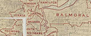
Booroodabin Division is a former local government area of Queensland, Australia, located in inner northern Brisbane immediately north of the Brisbane CBD today. It existed from 1879 to 1903.

<span class="mw-page-title-main">Bulimba Reach</span> Brisbane river section

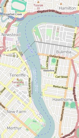
Bulimba Reach is a reach of the Brisbane River in Brisbane, Queensland, Australia.

Charles McLay was a Scottish-born architect in Queensland, Australia. Some of his works are now heritage-listed.

References

  1. 1 2 3 Australian Bureau of Statistics (28 June 2022). "Newstead (SAL)". 2021 Census QuickStats. Retrieved 26 September 2022. OOjs UI icon edit-ltr-progressive.svg
  2. "Central Ward". Brisbane City Council. Archived from the original on 18 February 2017. Retrieved 4 March 2017.
  3. 1 2 "Newstead – suburb in City of Brisbane (entry 49858)". Queensland Place Names. Queensland Government . Retrieved 26 January 2020.
  4. "Queensland Globe; Layer:Boundaries". Archived from the original on 19 December 2017. Retrieved 3 May 2022.
  5. 1 2 3 "Queensland Globe". State of Queensland . Retrieved 14 April 2020.
  6. "About The Boo". The Boo. 27 July 2017. Archived from the original on 15 April 2020. Retrieved 15 April 2020.
  7. "History". The Boo. 7 February 2018. Archived from the original on 15 April 2020. Retrieved 15 April 2020.
  8. 1 2 Queensland Family History Society (2010), Queensland schools past and present (Version 1.01 ed.), Queensland Family History Society, ISBN   978-1-921171-26-0
  9. "McKellars Official Map of Brisbane and Suburbs sheet 2" (Map). Queensland Government. 1895. Archived from the original on 8 November 2021. Retrieved 3 May 2022.
  10. "Queensland Twenty Chain series sheet 2533" (Map). Queensland Government. 1958. Archived from the original on 16 October 2020. Retrieved 3 May 2022.
  11. "Queensland state school - centre closures" (PDF). Queensland Government . 20 August 2013. Archived (PDF) from the original on 20 March 2022. Retrieved 7 April 2022.
  12. Brisbane's Newstead Branch Milne, Rod Australian Railway History, October 2005 pp403-423
  13. "Bulimba Reach – reach in the City of Brisbane (entry 4985)". Queensland Place Names. Queensland Government . Retrieved 15 April 2020.
  14. "Bulimba – suburb in the City of Brisbane (entry 49817)". Queensland Place Names. Queensland Government . Retrieved 15 April 2020.
  15. "Australian – American Memorial". Monument Australia. Archived from the original on 14 April 2020. Retrieved 14 April 2020.
  16. 1 2 Australian Bureau of Statistics (31 October 2012). "Newstead (Qld)". 2011 Census QuickStats. Retrieved 24 October 2013. OOjs UI icon edit-ltr-progressive.svg
  17. 1 2 Australian Bureau of Statistics (27 June 2017). "Newstead (SSC)". 2016 Census QuickStats. Retrieved 20 October 2018. OOjs UI icon edit-ltr-progressive.svg
  18. "Police Station (former)". Brisbane Heritage Register. Brisbane City Council . Retrieved 9 March 2020.
  19. "Brasch's Service Station (former)". Brisbane Heritage Register. Brisbane City Council . Retrieved 9 March 2020.
  20. "Booroodabin Bowls Club". Brisbane Heritage Register. Brisbane City Council . Retrieved 9 March 2020.
  21. "Primary Industries Dept Office". Brisbane Heritage Register. Brisbane City Council . Retrieved 9 March 2020.
  22. "Remnants of the second Breakfast Creek Bridge (South)". Brisbane Heritage Register. Brisbane City Council . Retrieved 9 March 2020.
  23. 1 2 "Newstead House and Park (entry 600265)". Queensland Heritage Register . Queensland Heritage Council. Retrieved 6 July 2013.
  24. "Waterloo Hotel". Brisbane Heritage Register. Brisbane City Council . Retrieved 9 March 2020.
  25. "22 Kyabra Street, Newstead". Brisbane Heritage Register. Brisbane City Council . Retrieved 9 March 2020.
  26. "Wilcox Mofflin Ltd (former)". Brisbane Heritage Register. Brisbane City Council . Retrieved 9 March 2020.
  27. "Australian Boot Factory (former)". Brisbane Heritage Register. Brisbane City Council . Retrieved 9 March 2020.
  28. "40 Newstead Terrace, Newstead". Brisbane Heritage Register. Brisbane City Council . Retrieved 9 March 2020.
  29. "Newstead Air Raid Shelter (entry 602483)". Queensland Heritage Register . Queensland Heritage Council. Retrieved 1 August 2014.
  30. "Substation No.47". Brisbane Heritage Register. Brisbane City Council . Retrieved 9 March 2020.
  31. "Newstead Gasworks No.2 gasholder (remnants) and guide framing (entry 601594)". Queensland Heritage Register . Queensland Heritage Council. Retrieved 1 August 2014.
  32. "Fortitude Valley State Secondary College". Fortitude Valley State Secondary College. 13 March 2019. Archived from the original on 14 March 2020. Retrieved 14 April 2020.