
St Lucia is a riverside suburb in the City of Brisbane, Queensland, Australia. The University of Queensland is the main attraction of St Lucia, with the university and its residential colleges covering a large proportion of the suburb. According to the 2021 census, St Lucia had a population of 12,220 people.

Chapel Hill is a western suburb in the City of Brisbane, Queensland, Australia. In the 2021 census, Chapel Hill had a population of 10,511 people.
The Division of Ryan is an Australian Electoral Division in Queensland.

Jindalee is a south-western residential suburb in the City of Brisbane, Queensland, Australia. In the 2021 census, Jindalee had a population of 5,320 people.

Taringa is a suburb in the City of Brisbane, Queensland, Australia. In the 2021 census, Taringa had a population of 8,732 people.

Bellbowrie is a suburb in the City of Brisbane, Queensland, Australia. In the 2021 census, Bellbowrie had a population of 5,495 people.

Brookfield is a rural residential suburb in the City of Brisbane, Queensland, Australia. In the 2021 census, Brookfield had a population of 3,640 people.
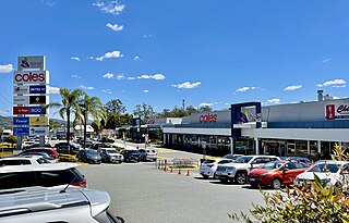
Kenmore is a riverside suburb in the City of Brisbane, Queensland, Australia. In the 2021 census, Kenmore had a population of 9,675 people.
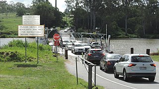
Moggill is a suburb in the City of Brisbane, Queensland, Australia. In the 2021 census, Moggill had a population of 5,029 people.

Mount Ommaney is a south-western riverside suburb in the City of Brisbane, Queensland, Australia. The mountain of the same name is located within the locality. In the 2021 census, Mount Ommaney had a population of 2,503 people.

Jamboree Heights is a south-western suburb in the City of Brisbane, Queensland, Australia. In the 2021 census, Jamboree Heights had a population of 3,141 people.

Anstead is an outer western suburb in the City of Brisbane, Queensland, Australia. In the 2021 census, Anstead had a population of 1,522 people.

Upper Brookfield is an outer western suburb in the City of Brisbane, Queensland, Australia. In the 2021 census, Upper Brookfield had a population of 857 people.

Chuwar is a town and suburb of Ipswich in the City of Ipswich and a locality of the City of Brisbane in South East Queensland, Australia. In the 2021 census, the suburb of Chuwar had a population of 2,178 people.

Pullenvale is a rural residential suburb in the City of Brisbane, Queensland, Australia. In the 2021 census, Pullenvale had a population of 3,276 people.
Riverview is a suburb of Ipswich in the City of Ipswich, Queensland, Australia. In the 2021 census, Riverview had a population of 3,067 people.

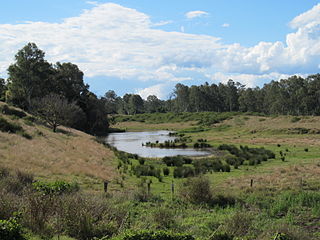
Moggill Creek is a creek in Brisbane, the largest city in Queensland, Australia. The creek rises on the Taylor Range and runs in a south-easterly direction from the southern edge of Brisbane Forest Park in Kholo and Pullenvale, flowing through Upper Brookfield, Brookfield and joining the Brisbane River at Kenmore. Before entering the Brisbane River the creek is crossed by Moggill Road and winds through Rafting Ground Reserve.
The Kenmore Bypass is a proposed 3.3-kilometre (2.1 mi) arterial road in Brisbane, Australia, which would directly link Moggill Road in Pullenvale to the Centenary Motorway in Fig Tree Pocket. If constructed, the road would make use of a corridor that has been preserved since the 1960s. The bypass is Stage 1 of the planned Moggill Pocket Arterial Road.

Moggill Road is a major road in Brisbane, Queensland, Australia. It commences at High Street at Toowong and terminates at the Moggill Ferry in Moggill. It is part of State Route 33. The road carried an average of 39,305 vehicles per day between July and December 2014.

The Pullenvale Ward is a Brisbane City Council ward covering Pullenvale, Anstead, Bellbowrie, Brookfield, Karana Downs, Kenmore, Kenmore Hills, Kholo, Lake Manchester, Moggill, Mount Crosby, Pinjarra Hills, Upper Brookfield and parts of Chapel Hill and Chuwar.


