Graceville, Queensland

Last updated

Graceville
Brisbane,  Queensland
Graceville Uniting Church, Graceville, Queensland, Australia 07.jpg
Graceville Uniting Church, 2019
Australia Queensland location map.svg
Red pog.svg
Graceville
Coordinates 27°31′16″S152°58′55″E / 27.5211°S 152.9819°E / -27.5211; 152.9819 (Graceville (centre of suburb))
Population4,764 (2021 census) [1]
 • Density2,270/km2 (5,880/sq mi)
Postcode(s) 4075
Elevation20 m (66 ft)
Area2.1 km2 (0.8 sq mi)
Time zone AEST (UTC+10:00)
Location
LGA(s) City of Brisbane
(Tennyson Ward) [2]
State electorate(s) Miller
Federal division(s) Moreton
Suburbs around Graceville:
Chelmer Chelmer Chelmer
Fig Tree Pocket Graceville Indooroopilly
Sherwood Sherwood Tennyson

Graceville is a suburb in the City of Brisbane, Queensland, Australia. [3] In the 2021 census, Graceville had a population of 4,764 people. [1]

Contents

Geography

Real estate map of The Graceville Estate, circa 1888 Real estate map of The Graceville Estate, ca. 1888 (26305569992).jpg
Real estate map of The Graceville Estate, circa 1888

Graceville is located 7.8 kilometres (4.8 mi) south-west of the Brisbane CBD, and is bordered by the Brisbane River to the North-East and West, Oxley Creek to the East, Chelmer to the North and Sherwood to the South.

The suburb is centred on Graceville railway station ( 27°31′14″S152°58′33″E / 27.5206°S 152.9759°E / -27.5206; 152.9759 (Graceville railway station) ) on the Ipswich railway line, and is predominantly residential, with houses generally being in the Queenslander style. The main roads in Graceville are Oxley Road, Graceville Avenue and Honour Avenue. The suburb also has a number of parks including Simpson's Playground, Graceville Memorial Park, and Faulkner Park.

History

A Baptist chapel opened near the junction of Oxley Creek and the Brisbane River on Sunday 22 May 1864. It was on land donated by John and Thomas Strong (approx 27°31′27″S152°59′37″E / 27.5242°S 152.9937°E / -27.5242; 152.9937 (Oxley Creek Baptist chapel (former)) ). [4] The Oxley Creek chapel was also used by other denominations, particularly the Presbyterians. It is unclear when the chapel closed but it is no longer extant. [5]

Railway at Graceville, circa 1915 StateLibQld 1 182335 Railway line at Graceville, ca. 1915.jpg
Railway at Graceville, circa 1915

The suburb takes its name from its railway station, which in turn was named on 4 February 1875 by the Queensland Railways Department after Grace Grimes, the daughter of Samuel Grimes. [3] [6]

In 1879, the local government area of Yeerongpilly Division was created. In 1891, parts of Yeerongpilly Division were excised to create Sherwood Division becoming a Shire in 1903 which contained the suburb of Graceville. In 1925, the Shire of Sherwood was amalgamated into the City of Brisbane. [7]

In December 1887, allotments in re-subdivisions 1 to 227 of subdivision 2 of portion 17, County of Stanley, Parish of Oxley, of "Graceville Park Estate" were advertised to be auctioned by R.J. Cottell, Auctioneer. A map advertising the auction states the estate includes Park Road, White Street, and Alfred Street. [8] The classified advertisement for the auction states the estate is "only a stone's throw from the Railway Station and "is a splendid piece of ground, with a gentle slope to the river." [9]

In December 1911, 207 allotments of the "Graceville Estate" were advertised to be auctioned by Currie, Buchanan & Co. Ltd. Auctioneers. A map advertising the auction states that the estate was "situated within easy walking distance of Graceville Railway Station". [10] The classified advertisement for the auction states the estate had "Cool, invigorating breeze, every allotment ready to build on, right aspect, abundance of fresh air, charming views, exclusive neighbourhood." [11]

On 24 April 1926, the "Memorial Park Estate" was advertised by Realty Development Co. Ltd. The advertisements in the Telegraph included a "catch-phrase" competition with first prize being a block of land in the Memorial Park Estate. [12]

In June 1926, 43 allotments of the "Greenfield Estate" were advertised to be auctioned by Charlton, Elliot and Sons. A map advertising the auction states that the estate was "within easy walking distance of Graceville Station". [13] The classified advertisement for the auction states the estate was in "easy walking distance to station, good train service, water and electric light". [14]

Graceville Baptist Church opened on Saturday 22 January 1927. [15] [16] [17] [18] The building was 31 by 21 feet (9.4 by 6.4 m) in size and could seat 100 people. [19]

New classroom, Graceville State School, 1952 Graceville State School. new classroom, 1952.jpg
New classroom, Graceville State School, 1952

Graceville State School opened on 13 August 1928. [20]

Graceville Uniting Church was opened in 1930. It was designed and built by local contractor Walter Taylor. It is a noted landmark in the suburb. [21]

Christ the King Catholic Primary School opened on 25 January 1937 with an initial 60 students with four Presentation Sisters as teachers. [20] [22]

St Peter's Anglican Church was dedicated on 1 July 1956 by Venerable Frank Knight. Its last service was held on 27 February 1982. [23] It was on Graceville Avenue (approx 27°31′20″S152°59′00″E / 27.5221°S 152.9832°E / -27.5221; 152.9832 (St Peter's Anglican Church (former)) ). [24] [25]

Demographics

In the 2011 census, Graceville recorded a population of 4,213 people, 51.7% female and 48.3% male. The median age of the Graceville population was 37 years of age, the same as the national median. 77.1% of people living in Graceville were born in Australia, compared to the national average of 69.8%; the next most common countries of birth were England 4.4%, New Zealand 2.9%, United States of America 1.1%, Scotland 0.9%, South Africa 0.8%. 89.4% of people spoke only English at home; the next most popular languages were 0.8% Vietnamese, 0.7% Mandarin, 0.6% Polish, 0.5% German, 0.5% Cantonese. [26]

In the 2016 census, Graceville had a population of 4,634 people. [27]

In the 2021 census, Graceville had a population of 4,764 people. [1]

Heritage listings

Beth-Eden Beth-Eden entrance.jpg
Beth-Eden
Stands for spectators, Graceville Memorial Park, Graceville Memorial Park 01.jpg
Stands for spectators, Graceville Memorial Park,

Graceville has a number of heritage-listed sites, including:

Education

Graceville State School, 2023 Graceville State School, 2023.jpg
Graceville State School, 2023

Graceville State School is a government primary (Prep-6) school for boys and girls at 23 Acacia Avenue ( 27°31′03″S152°58′43″E / 27.5175°S 152.9787°E / -27.5175; 152.9787 (Graceville State School) ). [49] [50] In 2017, the school had an enrolment of 761 students with 58 teachers (44 full-time equivalent) and 18 non-teaching staff (14 full-time equivalent). [51]

Christ the King School is a Catholic primary (Prep-6) school for boys and girls at 7 Randolph Street ( 27°31′11″S152°58′39″E / 27.5197°S 152.9774°E / -27.5197; 152.9774 (Christ the King School) ). [49] [52] In 2017, the school had an enrolment of 267 students with 23 teachers (16 full-time equivalent) and 15 non-teaching staff (8 full-time equivalent). [51]

There are no secondary schools in Graceville. The nearest government secondary school are Corinda State High School in Corinda to the wouth and Indooroopilly State High School in Indooroopilly to the north. [53]

Amenities

There are two shopping precincts in the suburb:

Graceville Uniting Church is at 215 Oxley Road ( 27°31′14″S152°58′44″E / 27.5206°S 152.9790°E / -27.5206; 152.9790 (Graceville Uniting Church) ). [55] [56] [57] It is part of the South Moreton Presbytery of the Uniting Church in Australia. [58]

Graceville Memorial Oval, which has the Memorial for the soldiers who died in wars that lived in the area, and also serves as the home of both Western Suburbs Cricket Club and Wests Taylor Bridge Rugby Club.

Graceville has a number of sporting clubs, including

Related Research Articles

<span class="mw-page-title-main">Coorparoo, Queensland</span> Suburb of Brisbane, Queensland, Australia

Coorparoo is a suburb in the inner City of Brisbane, Queensland, Australia. In the 2021 census, Coorparoo had a population of 18,132 people.

<span class="mw-page-title-main">Toowong</span> Suburb of Brisbane, Queensland, Australia

Toowong is a riverside suburb in the City of Brisbane, Queensland, Australia. In the 2021 census, Toowong had a population of 12,556 people with a median weekly household income of $1,927.

<span class="mw-page-title-main">Alderley, Queensland</span> Suburb of Brisbane, Queensland, Australia

Alderley is a northern suburb in the City of Brisbane, Queensland, Australia. In the 2021 census, Alderley had a population of 6,748 people.

<span class="mw-page-title-main">Annerley</span> Suburb of Brisbane, Queensland, Australia

Annerley is a suburb in the City of Brisbane, Queensland, Australia. In the 2021 census, Annerley had a population of 11,891 people.

<span class="mw-page-title-main">Oxley, Queensland</span> Suburb of Brisbane, Queensland, Australia

Oxley is a south-western suburb in the City of Brisbane, Queensland, Australia. In the 2021 census, Oxley had a population of 9,100 people.

<span class="mw-page-title-main">Clayfield, Queensland</span> Suburb of Brisbane, Queensland, Australia

Clayfield is a suburb in the City of Brisbane, Queensland, Australia. In the 2021 census, Clayfield had a population of 10,897 people.

<span class="mw-page-title-main">Ashgrove, Queensland</span> Suburb of Brisbane, Queensland, Australia

Ashgrove is a suburb in the City of Brisbane, Queensland, Australia. In the 2021 census, Ashgrove had a population of 13,450 people.

<span class="mw-page-title-main">Gaythorne, Queensland</span> Suburb of Brisbane, Queensland, Australia

Gaythorne is a suburb in the City of Brisbane, Queensland, Australia. In the 2021 census, Gaythorne had a population of 3,158 people.

<span class="mw-page-title-main">Indooroopilly, Queensland</span> Suburb of Brisbane, Queensland, Australia

Indooroopilly is a riverside suburb 7.8 kilometres (4.8 mi) south-west of the Brisbane CBD, Queensland, Australia. In the 2021 census, Indooroopilly had a population of 13,622 people.

<span class="mw-page-title-main">Middle Park, Queensland</span> Suburb of Brisbane, Queensland, Australia

Middle Park is a residential south-western suburb in the Centenary Suburbs in the City of Brisbane, Queensland, Australia. In the 2021 census, Middle Park had a population of 3,845 people.

<span class="mw-page-title-main">Chelmer, Queensland</span> Suburb of Brisbane, Queensland, Australia

Chelmer is a south-western suburb in the City of Brisbane, Queensland, Australia. In the 2021 census, Chelmer had a population of 3,325 people.

<span class="mw-page-title-main">Corinda, Queensland</span> Suburb of Brisbane, Queensland, Australia

Corinda is a suburb in the City of Brisbane, Queensland, Australia. In the 2021 census, Corinda had a population of 5,555 people.

Newmarket is a north-west suburb in the City of Brisbane, Queensland, Australia. In the 2021 census, Newmarket had a population of 5,083 people.

<span class="mw-page-title-main">Enoggera, Queensland</span> Suburb of Brisbane, Queensland, Australia

Enoggera is a north-western suburb in the City of Brisbane, Queensland, Australia. It is home to the Gallipoli Barracks.

<span class="mw-page-title-main">Bulimba, Queensland</span> Suburb of Brisbane, Queensland, Australia

Bulimba is a suburb in the City of Brisbane, Queensland, Australia. In the 2021 census, Bulimba had a population of 7,623 people.

<span class="mw-page-title-main">Yeerongpilly, Queensland</span> Suburb of Brisbane, Queensland, Australia

Yeerongpilly is a southern suburb in the City of Brisbane, Queensland, Australia. In the 2021 census, Yeerongpilly had a population of 2,033 people.

<span class="mw-page-title-main">Sherwood, Queensland</span> Suburb of Brisbane, Queensland, Australia

Sherwood is a suburb in the City of Brisbane, Queensland, Australia. In the 2021 census, Sherwood had a population of 6,082 people.

<span class="mw-page-title-main">Shire of Sherwood</span> Former local government area of Queensland

The Shire of Sherwood is a former local government area of Queensland, Australia, located in south-western Brisbane in and around the suburb of Sherwood.

<span class="mw-page-title-main">Central Buildings</span> Historic site in Queensland, Australia

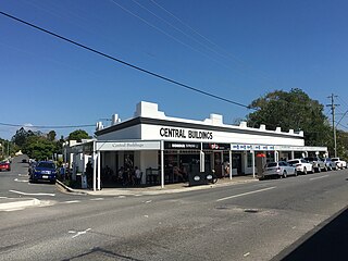
The Central Buildings are a heritage-listed series of six shops located at 327 Honour Avenue, Graceville, Brisbane, Queensland, Australia. They are located between Verney Road West and Rakeevan Road. They are listed on the Brisbane Heritage Register.

<span class="mw-page-title-main">William Robert Black</span>

William Robert Black (1859–1930) was an Australia mine-owner and philanthropist. He donated to establish many Presbyterian churches and supported schools, orphanages and other charitable institutions in Queensland.

References

  1. 1 2 3 Australian Bureau of Statistics (28 June 2022). "Graceville (SAL)". 2021 Census QuickStats. Retrieved 28 February 2023. OOjs UI icon edit-ltr-progressive.svg
  2. "Tennyson Ward". Brisbane City Council. Archived from the original on 4 March 2017. Retrieved 19 March 2017.
  3. 1 2 "Graceville – suburb in City of Brisbane (entry 48295)". Queensland Place Names. Queensland Government . Retrieved 18 July 2021.
  4. "TELEGRAPHIC NEWS". The Brisbane Courier . Vol. XVIII, no. 2038. Queensland, Australia. 25 May 1864. p. 2. Archived from the original on 8 December 2021. Retrieved 4 December 2021 via National Library of Australia.
  5. Parker, David (August 2015). "A Decade of Church growth 150 Years Ago" (PDF). The Queensland Baptist Forum (91): 5. Archived (PDF) from the original on 4 December 2021. Retrieved 4 December 2021.
  6. "Graceville – railway station in City of Brisbane (entry 14512)". Queensland Place Names. Queensland Government . Retrieved 10 June 2019.
  7. Fones, Ralph (1 January 1993). "Suburban conservatism in the Sherwood Shire 1891-1920". UQ eSpace. Archived from the original on 2 March 2020. Retrieved 2 March 2020.
  8. "Graceville Park [Estate] R.J. Cottell, Auctioneer; F.G. Shaw, Surveyor". State Library of Queensland. 1887. Archived from the original on 19 August 2023. Retrieved 27 May 2022.
  9. "Advertising". The Telegraph . No. 4, 693. Queensland, Australia. 22 October 1887. p. 7. Archived from the original on 19 August 2023. Retrieved 27 May 2022 via National Library of Australia.
  10. "Graceville Estate Currie, Buchanan & Co., Auctioneers; Harry Raff, Surveyor". State Library of Queensland. 1911. Retrieved 27 May 2022.
  11. "Advertising". The Telegraph . No. 12, 193. Queensland, Australia. 15 December 1911. p. 12 (SECOND EDITION). Archived from the original on 19 August 2023. Retrieved 27 May 2022 via National Library of Australia.
  12. "1926 Graceville - Memorial Park Estate". Suburb Maps. Archived from the original on 23 April 2023. Retrieved 24 April 2023.
  13. "Greenfields Estate, Graceville Charlton, Elliott & Sons, Auctioneers". State Library of Queensland. 1926. Archived from the original on 19 August 2023. Retrieved 27 May 2022.
  14. "Advertising". The Telegraph . No. 16, 706. Queensland, Australia. 18 June 1926. p. 20. Archived from the original on 19 August 2023. Retrieved 27 May 2022 via National Library of Australia.
  15. "Queensland Baptist churches by date of erection/opening". Baptist Church Archives Queensland. Archived from the original on 26 November 2021. Retrieved 29 November 2021.
  16. "1926 Graceville". Baptist Church Archives Queensland. Archived from the original on 26 November 2021. Retrieved 29 November 2021.
  17. "Untitled". The Brisbane Courier . No. 21, 526. Queensland, Australia. 22 January 1927. p. 8. Retrieved 2 December 2021 via National Library of Australia.
  18. "BAPTIST". The Telegraph . No. 16892. Queensland, Australia. 22 January 1927. p. 13 (SECOND EDITION). Archived from the original on 8 December 2021 via National Library of Australia.
  19. "GRACEVILLE BAPTISTS". The Brisbane Courier . No. 21, 527. Queensland, Australia. 24 January 1927. p. 19. Archived from the original on 8 December 2021. Retrieved 2 December 2021 via National Library of Australia.
  20. 1 2 Queensland Family History Society (2010). Queensland schools past and present (Version 1.01 ed.). Queensland Family History Society. ISBN   978-1-921171-26-0.
  21. 1 2 "Graceville Uniting Church Complex (entry 601584)". Queensland Heritage Register . Queensland Heritage Council. Retrieved 19 June 2013.
  22. "Our History". Christ the King Catholic Primary School. Archived from the original on 29 July 2019. Retrieved 30 July 2019.
  23. "Closed Anglican Churches". Anglican Church South Queensland. Archived from the original on 3 April 2019. Retrieved 29 June 2020.
  24. Gregory's Street Directory of Brisbane and Suburbs and Metropolitan Road Guide (11 ed.). 1975. pp. Map 42 B10.
  25. Universal Business Directories (Aust.) Pty. Ltd (1990). UBD street directory. Brisbane. Universal Business Directories (Australia). pp. Map 33 K7. Archived from the original on 24 August 2020. Retrieved 4 July 2020.{{cite book}}: |author1= has generic name (help)
  26. Australian Bureau of Statistics (31 October 2012). "Graceville (SSC)". 2011 Census QuickStats. Retrieved 19 August 2023. OOjs UI icon edit-ltr-progressive.svg
  27. Australian Bureau of Statistics (27 June 2017). "Graceville (SSC)". 2016 Census QuickStats. Retrieved 20 October 2018. OOjs UI icon edit-ltr-progressive.svg
  28. "Beth-Eden (entry 600215)". Queensland Heritage Register . Queensland Heritage Council. Retrieved 19 June 2013.
  29. "Glenrae". Brisbane Heritage Register. Brisbane City Council . Retrieved 9 March 2020.
  30. "Christ the King Roman Catholic Church". Brisbane Heritage Register. Brisbane City Council . Retrieved 9 March 2020.
  31. "161 Graceville Avenue Graceville". Brisbane Heritage Register. Brisbane City Council . Retrieved 9 March 2020.
  32. "Central Buildings". Brisbane Heritage Register. Brisbane City Council . Retrieved 9 March 2020.
  33. "Concrete Block Residence". Brisbane Heritage Register. Brisbane City Council . Retrieved 9 March 2020.
  34. "17 Kew Road Graceville". Brisbane Heritage Register. Brisbane City Council . Retrieved 9 March 2020.
  35. "Graceville Railway Station (entry 602717)". Queensland Heritage Register . Queensland Heritage Council. Retrieved 19 June 2013.
  36. "Brick War Service Home". Brisbane Heritage Register. Brisbane City Council . Retrieved 9 March 2020.
  37. "Brick War Service Home". Brisbane Heritage Register. Brisbane City Council . Retrieved 9 March 2020.
  38. "Brick War Service Home". Brisbane Heritage Register. Brisbane City Council . Retrieved 9 March 2020.
  39. "Glengarry". Brisbane Heritage Register. Brisbane City Council . Retrieved 9 March 2020.
  40. "The Gables". Brisbane Heritage Register. Brisbane City Council . Retrieved 9 March 2020.
  41. "Graceville Memorial Park (entry 602443)". Queensland Heritage Register . Queensland Heritage Council. Retrieved 19 June 2013.
  42. "8 Rakeevan Road, Graceville". Brisbane Heritage Register. Brisbane City Council . Retrieved 9 March 2020.
  43. "Bulk store". Brisbane Heritage Register. Brisbane City Council . Retrieved 9 March 2020.
  44. "Brick War Service Home". Brisbane Heritage Register. Brisbane City Council . Retrieved 9 March 2020.
  45. "Brick War Service Home". Brisbane Heritage Register. Brisbane City Council . Retrieved 9 March 2020.
  46. "Anzac Cottage". Brisbane Heritage Register. Brisbane City Council . Retrieved 9 March 2020.
  47. "Roslin Villa". Brisbane Heritage Register. Brisbane City Council . Retrieved 9 March 2020.
  48. "Sherwood Scout Hall". Brisbane Heritage Register. Brisbane City Council . Retrieved 9 March 2020.
  49. 1 2 "State and non-state school details". Queensland Government. 9 July 2018. Archived from the original on 21 November 2018. Retrieved 21 November 2018.
  50. "Graceville State School". Graceville State School. 29 November 2020. Archived from the original on 14 July 2023. Retrieved 19 August 2023.
  51. 1 2 "ACARA School Profile 2017". Archived from the original on 22 November 2018. Retrieved 22 November 2018.
  52. "Christ the King School". Archived from the original on 11 April 2012. Retrieved 21 November 2018.
  53. "Queensland Globe". State of Queensland . Retrieved 29 July 2019.
  54. 1 2 "Building areas – Queensland". Queensland Open Data. Queensland Government. 17 November 2020. Archived from the original on 23 October 2020. Retrieved 17 November 2020.
  55. "Find a Church". Uniting Church in Australia, Queensland Synod. Archived from the original on 24 October 2020. Retrieved 22 November 2020.
  56. "Graceville Uniting Church". Archived from the original on 21 October 2021. Retrieved 19 October 2021.
  57. Design, UBC Web. "Graceville Uniting Church | Churches Australia". churchesaustralia.org. Archived from the original on 28 October 2021. Retrieved 19 October 2021.
  58. "Queensland congregations and faith communities" (PDF). Uniting Church in Australia, Queensland Synod . March 2019. Archived (PDF) from the original on 20 October 2021. Retrieved 19 October 2021.
  59. "Graceville Croquet Club". Croquet Queensland. Archived from the original on 6 May 2021. Retrieved 8 December 2021.

Further reading