Doolandella, Queensland

Last updated

Doolandella
Brisbane,  Queensland
Doolandella, Queensland.JPG
Rockfield Street
Australia Queensland location map.svg
Red pog.svg
Doolandella
Coordinates 27°36′46″S152°59′11″E / 27.6127°S 152.9863°E / -27.6127; 152.9863 (Doolandella (centre of suburb))
Population7,123 (2021 census) [1]
 • Density2,035/km2 (5,270/sq mi)
Established1976
Postcode(s) 4077
Area3.5 km2 (1.4 sq mi)
Time zone AEST (UTC+10:00)
Location20.7 km (13 mi) SSW of Brisbane CBD
LGA(s) City of Brisbane
(Forest Lake Ward) [2]
State electorate(s) Inala
Federal division(s) Oxley
Suburbs around Doolandella:
Inala Durack Willawong
Forest Lake Doolandella Pallara
Forest Lake Pallara Pallara

Doolandella is an outer western suburb in the City of Brisbane, Queensland, Australia. [3] In the 2021 census, Doolandella had a population of 7,123 people. [1]

Contents

Geography

Doolandella is 20.7 kilometres (13 mi) south-west by road from the Brisbane CBD. [4] Blunder Creek forms the eastern and southern boundaries of the suburb. [5]

The suburb has access to the Ipswich Motorway via Blunder Road as well as the Logan Motorway to the south. [5]

The land use is almost entirely residential. [5]

History

Doolandella was declared as an official suburb in 1976. [6] The name Doolandella, or Dulandella as expressed by Aboriginal Australians, is a Yuggera word referring to the Geebung tree, a broad leaved shrub with yellow fruit which grows in the area. [6]

Demographics

In the 2011 census, Doolandella had a population of 3,105 people, 49% female and 51% male. The median age of the Doolandella population was 30 years of age, 7 years below the Australian median. 55.6% of people living in Doolandella were born in Australia, compared to the national average of 69.8%; the next most common countries of birth were Vietnam 11.9%, New Zealand 5.6%, India 2.9%, England 2.1%, Fiji 1.7%. 53.3% of people spoke only English at home; the next most popular languages were 19.5% Vietnamese, 2.7% Samoan, 2.3% Hindi, 2.1% Mandarin, 1.9% Spanish. [7]

In the 2016 census, Doolandella had a population of 4,817 people. [8]

In the 2021 census, Doolandella had a population of 7,123 people. [1]

Education

There are no schools within the suburb. The nearest government primary schools are Servicetown South State School in neighbouring Inala to the north-west and Pallara State School in neighbouring Pallara to the south-east. The nearest government secondary schools are Forest Lake State High School in neighbouring Forest Lake to the south-west and Glenala State High School in neighbouring Durack to the north. [9]

Amenities

There are a number of parks in the area:

Related Research Articles

<span class="mw-page-title-main">Inala, Queensland</span> Suburb of Brisbane, Queensland, Australia

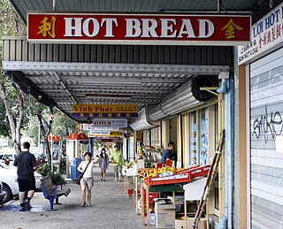
Inala is a south-western suburb in the City of Brisbane, Queensland, Australia. In the 2021 census, Inala had a population of 15,273 people.

<span class="mw-page-title-main">Chapel Hill, Queensland</span> Suburb of Brisbane, Queensland, Australia

Chapel Hill is a western suburb in the City of Brisbane, Queensland, Australia. In the 2021 census, Chapel Hill had a population of 10,511 people.

<span class="mw-page-title-main">Alderley, Queensland</span> Suburb of Brisbane, Queensland, Australia

Alderley is a northern suburb in the City of Brisbane, Queensland, Australia. In the 2021 census, Alderley had a population of 6,748 people.

<span class="mw-page-title-main">Oxley, Queensland</span> Suburb of Brisbane, Queensland, Australia

Oxley is a south-western suburb in the City of Brisbane, Queensland, Australia. In the 2021 census, Oxley had a population of 9,100 people.

<span class="mw-page-title-main">Darra, Queensland</span> Suburb of Brisbane, Queensland, Australia

Darra is a south-western suburb in the City of Brisbane, Queensland, Australia. In the 2016 census, Darra had a population of 4,343 people.

<span class="mw-page-title-main">Gaythorne, Queensland</span> Suburb of Brisbane, Queensland, Australia

Gaythorne is a suburb in the City of Brisbane, Queensland, Australia. In the 2021 census, Gaythorne had a population of 3,158 people.

<span class="mw-page-title-main">Forest Lake, Queensland</span> Suburb of Brisbane, Queensland, Australia

Forest Lake is an outer south-western suburb of the City of Brisbane, Queensland, Australia. In the 2021 census, Forest Lake had a population of 22,676 people.

<span class="mw-page-title-main">Corinda, Queensland</span> Suburb of Brisbane, Queensland, Australia

Corinda is a suburb in the City of Brisbane, Queensland, Australia. In the 2021 census, Corinda had a population of 5,555 people.

<span class="mw-page-title-main">Bridgeman Downs, Queensland</span> Suburb of Brisbane, Queensland, Australia

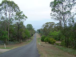
Bridgeman Downs is a northern suburb in the City of Brisbane, Queensland, Australia. It is located 15.2 kilometres (9.4 mi) from the city centre and borders City of Moreton Bay to the west.

<span class="mw-page-title-main">Willawong, Queensland</span> Suburb of Brisbane, Queensland, Australia

Willawong is an outer southern suburb in the City of Brisbane, Queensland, Australia. In the 2021 census, Willawong had a population of 145 people.

<span class="mw-page-title-main">Ellen Grove, Queensland</span> Suburb of Brisbane, Queensland, Australia

Ellen Grove is an outer south-western suburb in the City of Brisbane, Queensland, Australia. In the 2021 census, Ellen Grove had a population of 3,586 people.

<span class="mw-page-title-main">Durack, Queensland</span> Suburb of Brisbane, Queensland, Australia

Durack is an outer south-western suburb in the City of Brisbane, Queensland, Australia. In the 2016 census, Durack had a population of 7,487 people.

<span class="mw-page-title-main">Seventeen Mile Rocks, Queensland</span> Suburb of Brisbane, Queensland, Australia

Seventeen Mile Rocks is a suburb in the City of Brisbane, Queensland, Australia. In the 2021 census, Seventeen Mile Rocks had a population of 2,699 people.

<span class="mw-page-title-main">Pallara, Queensland</span> Suburb of Brisbane, Queensland, Australia

Pallara is an outer southern suburb in the City of Brisbane, Queensland, Australia. In the 2021 census, Pallara had a population of 3,861 people.

<span class="mw-page-title-main">Richlands, Queensland</span> Suburb of Brisbane, Queensland, Australia

Richlands is an outer south-western suburb in the City of Brisbane, Queensland, Australia. In the 2021 census, Richlands had a population of 5,621 people.

<span class="mw-page-title-main">Everton Hills, Queensland</span> Suburb of Moreton Bay, Queensland, Australia

Everton Hills is a suburb in the City of Moreton Bay, Queensland, Australia. In the 2021 census, Everton Hills had a population of 6,673 people.

Ringtail Creek is a rural locality in the Shire of Noosa, Queensland, Australia. In the 2021 census, Ringtail Creek had a population of 203 people.

<span class="mw-page-title-main">Bundamba, Queensland</span> Suburb of Ipswich, Queensland, Australia

Bundamba is a suburb of Ipswich in the City of Ipswich, Queensland, Australia. In the 2021 census, Bundamba had a population of 6,542 people.

<span class="mw-page-title-main">Wulkuraka, Queensland</span> Suburb of Ipswich, Queensland, Australia

Wulkuraka is a western suburb of Ipswich in the City of Ipswich, Queensland, Australia. In the 2016 census, Wulkuraka had a population of 1,234 people.

<span class="mw-page-title-main">Gailes, Queensland</span> Suburb of Ipswich, Queensland, Australia

Gailes is a suburb of Ipswich in the City of Ipswich, Queensland, Australia. In the 2016 census Gailes had a population of 1,828 people.

References

  1. 1 2 3 Australian Bureau of Statistics (28 June 2022). "Doolandella (SAL)". 2021 Census QuickStats. Retrieved 28 February 2023. OOjs UI icon edit-ltr-progressive.svg
  2. "Forest Lake Ward". Brisbane City Council. Archived from the original on 12 March 2017. Retrieved 12 March 2017.
  3. "Doolandella – suburb in City of Brisbane (entry 46544)". Queensland Place Names. Queensland Government . Retrieved 10 June 2019.
  4. Google (27 October 2023). "Brisbane GPO to Doolandella" (Map). Google Maps . Google. Retrieved 27 October 2023.
  5. 1 2 3 "Queensland Globe". State of Queensland . Retrieved 27 October 2023.
  6. 1 2 Mynott, Wicki (2009). 150 years: Richlands, Inala & neighbouring suburbs in Brisbane's South West. Richlands, Inala & Suburbs History Group. p. 78.
  7. Australian Bureau of Statistics (31 October 2012). "Doolandella (SSC)". 2011 Census QuickStats. Retrieved 27 October 2023. OOjs UI icon edit-ltr-progressive.svg
  8. Australian Bureau of Statistics (27 June 2017). "Doolandella (SSC)". 2016 Census QuickStats. Retrieved 20 October 2018. OOjs UI icon edit-ltr-progressive.svg
  9. "Layers: Locality; Schools and school catchments". Queensland Globe. Queensland Government . Retrieved 26 October 2023.
  10. 1 2 3 4 5 6 "Land for public recreation - Queensland". Queensland Open Data. Queensland Government. 20 November 2020. Archived from the original on 22 November 2020. Retrieved 22 November 2020.