Seven Hills, Queensland

Last updated

Map all coordinates using: OpenStreetMap
Seven Hills
Brisbane,  Queensland
Seven Hills Bushland Reserve (7117680399).jpg
Seven Hills Bushland Reserve
Australia Queensland location map.svg
Red pog.svg
Seven Hills
Coordinates 27°28′45″S153°04′30″E / 27.4791°S 153.075°E / -27.4791; 153.075 (Seven Hills (centre of suburb))
Population2,732 (SAL 2021) [1]
Postcode(s) 4170
Area1.6 km2 (0.6 sq mi)
Time zone AEST (UTC+10:00)
Location7.8 km (5 mi) E of Brisbane GPO
LGA(s) City of Brisbane
(Morningside Ward) [2]
State electorate(s)
Federal division(s) Griffith
Suburbs around Seven Hills:
Morningside Morningside Cannon Hill
Norman Park Seven Hills Carina
Norman Park Norman Park Camp Hill

Seven Hills is a suburb in the City of Brisbane, Queensland, Australia. [3] In the 2021 census, Seven Hills had a population of 2,732 people. [4]

Contents

Geography

Seven Hills is located 7.8 kilometres (4.8 mi) by road east of the Brisbane GPO. [5] It borders Camp Hill, Carina, Cannon Hill, Morningside, and Norman Park. [6]

As the name suggests, there are seven hills and the suburb and the hills themselves take their names from the Seven Hills of Rome. [3] The seven hills are:

All are within the current boundaries of the suburb, except for Esquiline Hill which is in the neighbouring suburb of Camp Hill on Tranter Avenue. [6] Also there is another hill in the suburb of Seven Hills, Lilian Hill ( 27°28′51″S153°04′44″E / 27.4809°S 153.0789°E / -27.4809; 153.0789 (Lilian Hill) ) which is not named after one of the Seven Hills of Rome. [14]

History

The name of the area first appeared in local maps in 1891 and 1895, when it was in the possession of landowners David Ham, John James Kingsbury (Ham's son-in-law) and Acheson Overend. The name was taken from the "Seven Hills Estate Co", a mining company whose own name reflected the terrain of the Creswick area north of Ballarat and of which Ham was a prominent shareholder. [15] The 1925 sub-division plan submitted by new owner and land developer Robert George Oates, incorporated Roman street names.[ citation needed ]

Seven Hills Presbyterian Church, at the time of opening, 1951 Seven Hills Presbyterian Church, at the time of opening, 1951.jpg
Seven Hills Presbyterian Church, at the time of opening, 1951

Between 1912 and 1926, the southern edge of the suburb was serviced by the Belmont Tramway which connected with the Queensland Government Railway at Norman Park. Initially the service was operated by the Belmont Shire Council until it was suspended in 1924.[ citation needed ] The service was reinstated by the Brisbane City Council in 1925 following the amalgamation of the local government authorities, but was again suspended in 1926.[ citation needed ] The tracks, which followed the present Oateson Skyline Drive and Ferguson Road and continued to Belmont along Old Cleveland Road, remained in place until 1934.[ citation needed ]

The Seven Hills Presbyterian Church opened on 1 July 1951 at 2 Servius Street ( 27°28′57″S153°04′32″E / 27.48251°S 153.07562°E / -27.48251; 153.07562 (Seven Hills Presbyterian Church (former)) ). [16] It was a timber building, capable of seating 200 people. In 1972, the church building was relocated to Carina. [17]

In 1953, the Brisbane City Council commenced a trolley-bus service, which connected the suburb with Fortitude Valley via Stanley Street, terminating just off Oateson Skyline Drive. The trolley-bus service ceased operation on 13 March 1969, when diesel buses took over the service.[ citation needed ]

Seven Hills State School, 1960 Seven Hills State School, Brisbane, August 1960 01.jpg
Seven Hills State School, 1960

Seven Hills State School opened on 25 January 1960 with an initial enrolment of 84 students rising to 141 students by the end of the first year. [18] [19] [20]

On 1 June 2001, Seven Hills was gazetted as a suburb by the Queensland Government, following a push by local residents to have it recognised independently of Norman Park. [21]

A Southbank Institute of Technology campus was operational in the suburb until 2010. The site has since become the Clearview Urban Village.

Demographics

At the 2011 census, Seven Hills had a population of 2,028 people, of whom 50% were female and 50% were male. [22] The median age of the population was 35; 2 years below the Australian median. 80.6% of people living in Seven Hills were born in Australia, with the next most common countries of birth being England (3.6%), New Zealand (3.6%), South Africa (0.8%), India (0.6%), and the United States (0.6%). 90.3% of people spoke English as their first language, while the other most common responses were Japanese (0.6%), Mandarin (0.6%), Spanish (0.5%), Tagalog (0.4%), and German (0.4%). [22]

In the 2016 census, Seven Hills had a population of 2,211 people. [23]

In the 2021 census, Seven Hills had a population of 2,732 people. [4]

Education

Seven Hill State School, 2023 Seven Hill State School, 2023 01.jpg
Seven Hill State School, 2023

Seven Hills State School is a government primary (Prep-6) school for boys and girls at 152 D'Arcy Road ( 27°28′46″S153°04′29″E / 27.4794°S 153.0747°E / -27.4794; 153.0747 (Seven Hills State School) ). [24] [25] In 2018, the school had an enrolment of 522 students with 38 teachers (33 full-time equivalent) and 25 non-teaching staff (14 full-time equivalent). [26] It includes a special education program. [24]

There are no secondary schools in Seven Hills. The nearest government secondary schools are Balmoral State High School in Balmoral to the north, Whites Hill State College in neighbouring Camp Hill to the south-east, and Coorparoo Secondary College in Coorparoo to the south-west. [27]

Public transport

There has been no railway station in Seven Hills since the closure of the Belmont Tramway in 1926, but Norman Park and Morningside stations are within walking distance of the western side of the suburb. Three radial bus corridors serve the suburb. Two express bus routes alternate to provide a connection between the Brisbane central business district and Cannon Hill Shopping Centre bus station along a corridor that passes through Seven Hills. One all-stops bus route passes centrally through Seven Hills on a route connecting Fortitude Valley and Carindale Shopping Centre. A peak route and an all-stops route connect Fortitude Valley and Cannon Hill Shopping Centre, passing along the southern border of Seven Hills.[ citation needed ]

Cycling and walking

The main thoroughfare of Oateson Skyline Drive includes bicycle lanes, which continue southward along Wiles Street, Camp Hill and provide connectivity with the citywide bicycle network.[ citation needed ]

There is a network of narrow, and generally steep heritage walking paths located within public easements between residential properties. The smaller local streets and the major roads mostly have paved footpaths on one or both sides. Oateson Skyline Drive is median-divided and contains kerb extensions that promote safe pedestrian crossing. Aside from a small number of local parks, the major recreational walking attraction is the 52 Hectare Seven Hills Bushland Reserve located on the north east side of the suburb. The reserve contains a signed network of tracks for walking and fire access.[ citation needed ]

Related Research Articles

<span class="mw-page-title-main">Quirinal Hill</span> One of the seven hills of Rome, Italy

The Quirinal Hill is one of the Seven Hills of Rome, at the north-east of the city center. It is the location of the official residence of the Italian head of state, who resides in the Quirinal Palace; by metonymy "the Quirinal" has come to stand for the Italian president. The Quirinal Palace has an extension of 1.2 million square feet.

<span class="mw-page-title-main">Seven hills of Rome</span> Geographical heart of Rome, Italy, within the walls of the city

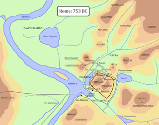
The seven hills of Rome east of the river Tiber form the geographical heart of Rome, within the walls of the city.

<span class="mw-page-title-main">Aventine Hill</span> One of the seven hills of Rome, Italy

The Aventine Hill is one of the Seven Hills on which ancient Rome was built. It belongs to Ripa, the modern twelfth rione, or ward, of Rome.

The Caelian Hill is one of the famous seven hills of Rome.

<span class="mw-page-title-main">Viminal Hill</span> One of the seven hills of Rome, Italy

The Viminal Hill is the smallest of the famous Seven Hills of Rome. A finger-shape cusp pointing toward central Rome between the Quirinal Hill to the northwest and the Esquiline Hill to the southeast, it is home to the Teatro dell'Opera and the Termini Railway Station.

<span class="mw-page-title-main">Janiculum</span> Hill in western Rome, Italy

The Janiculum, occasionally known as the Janiculan Hill, is a hill in western Rome, Italy. Although it is the second-tallest hill in the contemporary city of Rome, the Janiculum does not figure among the proverbial Seven Hills of Rome, being west of the Tiber and outside the boundaries of the ancient city.

<span class="mw-page-title-main">St Lucia, Queensland</span> Suburb of Brisbane, Queensland, Australia

St Lucia is a riverside suburb in the City of Brisbane, Queensland, Australia. In the 2016 census St Lucia had a population of 12,574 people. The University of Queensland is the main attraction of St Lucia, with the university, and residential colleges covering a large proportion of the suburb. St Lucia is home to a diverse range of people and families. Typically, the student population of St Lucia is high, especially in dwellings in the immediate vicinity of the university, but the suburb is also home to wealthy professionals and families.

<span class="mw-page-title-main">West End, Queensland</span> Suburb of Brisbane, Queensland, Australia

West End is an inner southern suburb in the City of Brisbane, Queensland, Australia. In the 2016 census, West End had a population of 9,474 people.

<span class="mw-page-title-main">Carina, Queensland</span> Suburb of Brisbane, Queensland, Australia

Carina is a suburb in the City of Brisbane, Queensland, Australia. In the 2016 census, Carina had a population of 11,019 people.

<span class="mw-page-title-main">14 regions of Augustan Rome</span> Administrative subdivisions of ancient Rome

In 7 BC, Augustus divided the city of Rome into 14 administrative regions. These replaced the four regiones—or "quarters"—traditionally attributed to Servius Tullius, sixth king of Rome. They were further divided into official neighborhoods.

<span class="mw-page-title-main">Camp Hill, Queensland</span> Suburb of Brisbane, Queensland, Australia

Camp Hill is a suburb in the City of Brisbane, Queensland, Australia. In the 2021 census, Camp Hill had a population of 12 145 people.

<span class="mw-page-title-main">Pincian Hill</span> Hill in Rome, Italy

The Pincian Hill is a hill in the northeast quadrant of the historical centre of Rome. The hill lies to the north of the Quirinal, overlooking the Campus Martius. It was outside the original boundaries of the ancient city of Rome, and was not one of the Seven hills of Rome, but it lies within the wall built by Roman Emperor Aurelian between 270 and 273.

<span class="mw-page-title-main">Spring Hill, Queensland</span> Suburb of Brisbane, Queensland, Australia

Spring Hill is an inner northern suburb in the City of Brisbane, Queensland, Australia. In the 2016 census, Spring Hill had a population of 5,974 people.

<span class="mw-page-title-main">Hamilton, Queensland</span> Suburb of Brisbane, Queensland, Australia

Hamilton is an affluent riverside mixed-use suburb in the north-east of the City of Brisbane, Queensland, Australia. Hamilton is located along the north bank of the Brisbane River. In the 2021 census, Hamilton had a population of 8,922 people.

<span class="mw-page-title-main">Lytton, Queensland</span> Suburb of Brisbane, Queensland, Australia

Lytton is an outer riverside suburb in the City of Brisbane, Queensland, Australia. In the 2016 census, Lytton had a population of 6 people.

<span class="mw-page-title-main">Carina Heights, Queensland</span> Suburb of Brisbane, Queensland, Australia

Carina Heights is both a hill and a suburb in the City of Brisbane, Queensland, Australia. In the 2016 census, Carina Heights had a population of 6,732 people.

<span class="mw-page-title-main">Oppian Hill</span> Landmark of ancient Rome

The Oppian Hill is the southern spur of the Esquiline Hill, one of the Seven hills of Rome, Italy. It is separated from the Cispius on the north by the valley of the Suburra, and from the Caelian Hill on the south by the valley of the Colosseum. The Oppius and the Cispius together form the Esquiline plateau just inside the line of the Servian Wall.

<span class="mw-page-title-main">Velian Hill</span> Landmark of ancient Rome

The Velia — or Velian Hill or Velian Ridge — is a saddle or spur stretching out from the middle of the north side of the Palatine Hill towards the Oppian Hill in Rome.

<span class="mw-page-title-main">Municipio I</span> Municipio of Rome in Lazio, Italy

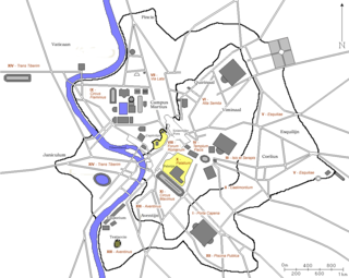
Municipio I is an administrative subdivision of the municipality of Rome, encompassing the centre of the city.

Acqua may refer to:

References

  1. Australian Bureau of Statistics (28 June 2022). "Seven Hills (Qld) (suburb and locality)". Australian Census 2021 QuickStats. Retrieved 28 June 2022.  OOjs UI icon edit-ltr-progressive.svg
  2. "Morningside Ward". Brisbane City Council. Archived from the original on 17 April 2017. Retrieved 12 March 2017.
  3. 1 2 "Seven Hills – suburb in City of Brisbane (entry 43020)". Queensland Place Names. Queensland Government . Retrieved 11 October 2020.
  4. 1 2 Australian Bureau of Statistics (28 June 2022). "Seven Hills (SAL)". 2021 Census QuickStats. Retrieved 28 February 2023. OOjs UI icon edit-ltr-progressive.svg
  5. "Brisbane GPO to Seven Hills". Google Maps. Archived from the original on 28 May 2022. Retrieved 19 October 2020.
  6. 1 2 "Queensland Globe". State of Queensland . Retrieved 18 October 2020.
  7. "Palatine Hill – hill in City of Brisbane (entry 25828)". Queensland Place Names. Queensland Government . Retrieved 11 October 2020.
  8. "Capitoline Hill – hill in City of Brisbane (entry 6152)". Queensland Place Names. Queensland Government . Retrieved 11 October 2020.
  9. "Quirinal Hill – hill in City of Brisbane (entry 27848)". Queensland Place Names. Queensland Government . Retrieved 11 October 2020.
  10. "Aventine Hill – hill in City of Brisbane (entry 1038)". Queensland Place Names. Queensland Government . Retrieved 11 October 2020.
  11. "Caelian Hill – hill in City of Brisbane (entry 5662)". Queensland Place Names. Queensland Government . Retrieved 11 October 2020.
  12. "Viminal Hill – hill in City of Brisbane (entry 36048)". Queensland Place Names. Queensland Government . Retrieved 11 October 2020.
  13. "Esquiline Hill – hill in City of Brisbane (entry 11871)". Queensland Place Names. Queensland Government . Retrieved 11 October 2020.
  14. "Lilian Hill – hill in City of Brisbane (entry 19306)". Queensland Place Names. Queensland Government . Retrieved 11 October 2020.
  15. Jolly, Eris (2016). Seven Hills of Brisbane (2 ed.). Queensland: N.E. & E.M. Jolly. p. 75. ISBN   978-0958114301.
  16. "New church hall". The Courier-mail . No. 4552. Queensland, Australia. 30 June 1951. p. 7. Archived from the original on 15 November 2023. Retrieved 15 November 2023 via National Library of Australia.
  17. "Seven Hills Presbyterian Church | Seven Hills". Queensland Religious Places Database. Archived from the original on 15 November 2023. Retrieved 15 November 2023.
  18. Queensland Family History Society (2010), Queensland schools past and present (Version 1.01 ed.), Queensland Family History Society, ISBN   978-1-921171-26-0
  19. "Agency ID 10942, Seven Hills State School". Queensland State Archives . Retrieved 15 November 2023.
  20. "History". Seven Hills State School. 9 March 2020. Archived from the original on 26 October 2023. Retrieved 14 November 2023.
  21. Jolly, Eris (2016). Seven Hills of Brisbane (2 ed.). Queensland: N.E. & E.M. Jolly. p. 73. ISBN   978-0958114301.
  22. 1 2 Australian Bureau of Statistics (31 October 2012). "Seven Hills, Qld (State Suburb)". 2011 Census QuickStats. Retrieved 23 October 2013. OOjs UI icon edit-ltr-progressive.svg
  23. Australian Bureau of Statistics (27 June 2017). "Seven Hills (SSC)". 2016 Census QuickStats. Retrieved 20 October 2018. OOjs UI icon edit-ltr-progressive.svg
  24. 1 2 "State and non-state school details". Queensland Government. 9 July 2018. Archived from the original on 21 November 2018. Retrieved 21 November 2018.
  25. "Seven Hills State School". Seven Hills State School. 16 August 2022. Archived from the original on 27 February 2021. Retrieved 14 November 2023.
  26. "ACARA School Profile 2018". Australian Curriculum, Assessment and Reporting Authority. Archived from the original on 27 August 2020. Retrieved 28 January 2020.
  27. "Layers: Locality; Schools and school catchments". Queensland Globe. Queensland Government. Archived from the original on 19 December 2017. Retrieved 14 November 2023.

Commons-logo.svg Media related to Seven Hills, Queensland at Wikimedia Commons