Parkinson, Queensland

Last updated

Parkinson
Brisbane,  Queensland
Aerial Image Parkinson.jpg
Aerial Image of Parkinson, 2019
Australia Queensland location map.svg
Red pog.svg
Parkinson
Coordinates 27°38′37″S153°01′45″E / 27.6436°S 153.0291°E / -27.6436; 153.0291 (Parkinson (centre of suburb))
Population10,878 (2016 census) [1]
 • Density1,327/km2 (3,436/sq mi)
Postcode(s) 4115
Area8.2 km2 (3.2 sq mi)
Time zone AEST (UTC+10:00)
Location23.0 km (14 mi) S of Brisbane GPO
LGA(s) City of Brisbane
(Calamvale Ward) [2]
State electorate(s) Algester
Federal division(s) Rankin
Suburbs around Parkinson:
Pallara Algester Calamvale
Larapinta Parkinson Drewvale
Forestdale
Hillcrest Browns Plains

Parkinson is an outer southern suburb in the City of Brisbane, Queensland, Australia. [3] In the 2016 census, Parkinson had a population of 10,878 people. [1]

Contents

Geography

"Welcome to Brisbane" sign on the Mount Lindesay Highway, 2014 Brisbane welcome Parkinson Beaudesert Rd.jpg
"Welcome to Brisbane" sign on the Mount Lindesay Highway, 2014

Parkinson is 23.0 kilometres (14.3 mi) by road south of the Brisbane GPO and borders Logan City.[ citation needed ]

The eastern boundary of Parkinson is marked by the Mount Lindesay Highway. The western boundary is aligned with the Sydney–Brisbane rail corridor. The Logan Motorway bisects the suburb. The northern half is mostly residential in nature with some parkland. The south remains uncleared with some industrial development emerging in the southeast corner. This corner of Parkinson is the southernmost part of the City of Brisbane.[ citation needed ]

History

The suburb was named after railway engineer Henry Parkinson on 12 June 1972 by the Queensland Place Names Board. [4] [3]

The suburb was predominantly bushland for many years, with urban development beginning in the mid 1990s. [3] By 2003, most of the northern areas of the suburb were developed into low density residential with further developments continuing in the western portion of the suburb. These final residential developments were completed in 2008. An industrial estate was developed in the south eastern corner of the suburb in 2009.[ citation needed ]

On 13 October 2011, Parkinson experienced an intense local thunderstorm with damaging winds, large hail and heavy rainfall. This thunderstorm was unusual compared to other storms which commonly occur in the area, due to the significant amount of hail accumulation which occurred throughout the suburb. This storm caused local flash flooding, roofs and ceilings to collapse, damaged cars and power outages. Some accumulations of ice from the storm had not melted 24 hours after the event. [5]

Demographics

In the 2011 census, the population of Parkinson was 9,539, 50.2% female and 49.8% male. [6] The median age of the Parkinson population was 34 years, 3 years below the Australian median. 62.5% of people living in Parkinson were born in Australia, compared to the national average of 69.8%; the next most common countries of birth were New Zealand 5.5%, England 4.4%, South Africa 2.6%, China 2%, India 1.9%. 74.1% of people spoke only English at home; the next most common languages were 3.7% Mandarin, 3% Cantonese, 1.4% Hindi, 1.3% Spanish, 1.2% Punjabi. [6]

In the 2016 census, Parkinson had a population of 10,878 people. [1]

Education

Ohana College is a private secondary (7-12) school for boys and girls at 61 Sandstone Street ( 27°39′20″S153°02′12″E / 27.6556°S 153.0368°E / -27.6556; 153.0368 (The Spot Academy) ). [7] It provides education specifically tailored for children who are at risk of disengaging from school. [8]

Australian Technology and Agricultural College – Parkinson is a private secondary (10-12) campus for boys and girls of Australian Technology and Agricultural College at North Maclean at 61 Sandstone Place ( 27°39′20″S153°02′12″E / 27.6555°S 153.0366°E / -27.6555; 153.0366 (Australian Technology and Agricultural College – Parkinson) ). [7] [9] Its focus is employability skills for children of school-leaving age targeting the trades and agriculture sectors. [10]

There are no government schools in Parkinson. The nearest government primary schools are to the north Algester State School in Algester, Calamvale Community College in Calamvale to the north-east, Stretton State College in Stretton to the east and Browns Plains State School in Browns Plains to the south-west. The nearest government secondary schools are Calamvale Community College in Calamvale to the north-east, Stretton State College in Stretton to the east and Browns Plains High State School to the south-west. [11]

Related Research Articles

<span class="mw-page-title-main">Calamvale, Queensland</span> Suburb of Brisbane, Queensland, Australia

Calamvale is a southern suburb in the City of Brisbane, Queensland, Australia. In the 2021 census, Calamvale had a population of 17,994 people.

<span class="mw-page-title-main">Mansfield, Queensland</span> Suburb of Brisbane, Queensland, Australia

Mansfield is a suburb in the City of Brisbane, Queensland, Australia. In the 2016 census, Mansfield had a population of 8,695 people.

<span class="mw-page-title-main">Wooloowin, Queensland</span> Suburb of Brisbane, Queensland, Australia

Wooloowin is a suburb in the City of Brisbane, Queensland, Australia. In the 2016 census, Wooloowin had a population of 3,938 people.

<span class="mw-page-title-main">Bowen Hills, Queensland</span> Suburb of Brisbane, Queensland, Australia

Bowen Hills is an inner north-eastern suburb in the City of Brisbane, Queensland, Australia. In the 2021 census, Bowen Hills had a population of 4,898 people.

<span class="mw-page-title-main">Acacia Ridge, Queensland</span> Suburb of Brisbane, Queensland, Australia

Acacia Ridge is a southern suburb in the City of Brisbane, Queensland, Australia. In the 2016 census, Acacia Ridge had a population of 7,429 people.

<span class="mw-page-title-main">Algester, Queensland</span> Suburb of Brisbane, Queensland, Australia

Algester is a southern suburb in the City of Brisbane, Queensland, Australia. In the 2016 census, Algester had a population of 8,433 people.

The Division of Moreton is an Australian Electoral Division in Queensland.

<span class="mw-page-title-main">Sunnybank Hills, Queensland</span> Suburb of Brisbane, Queensland, Australia

Sunnybank Hills is an outer southern suburb in the City of Brisbane, Queensland, Australia. In the 2021 census, Sunnybank Hills had a population of 18,085 people.

<span class="mw-page-title-main">Stretton, Queensland</span> Suburb of Brisbane, Queensland, Australia

Stretton is a southern suburb in the City of Brisbane, Queensland, Australia. In the 2016 census, Stretton had a population of 4,334. The suburb is known for its Hollywood-sized mansions on nearby streets off Gowan and Compton Roads.

<span class="mw-page-title-main">Kelvin Grove, Queensland</span> Suburb of Brisbane, Queensland, Australia

Kelvin Grove is an inner northern suburb in the City of Brisbane, Queensland, Australia. In the 2016 census, Kelvin Grove had a population of 7,927 people.

<span class="mw-page-title-main">Electoral district of Algester</span> State electoral district of Queensland, Australia

The electoral district of Algester is an electoral district of the Legislative Assembly of Queensland in south-west Brisbane. It includes the suburbs of Algester, Parkinson, Hillcrest, Boronia Heights, Forestdale, Larapinta, Heathwood, Forest Lake, Doolandella and Pallara, as well as the Greenbank Military Range. It borders the electoral districts of Sunnybank, Stretton, Logan, Lockyer, Bundamba and Inala.

<span class="mw-page-title-main">Carindale, Queensland</span> Suburb of Brisbane, Queensland, Australia

Carindale is a suburb of the City of Brisbane, Queensland, Australia. It is located 13.1 kilometres (8.1 mi) by road south-east of the Brisbane GPO, and borders Belmont, Carina, Carina Heights, Mackenzie, Mansfield, Mount Gravatt East, and Tingalpa. In the 2021 census, Carindale had a population of 16,535 people.

<span class="mw-page-title-main">Eight Mile Plains, Queensland</span> Suburb of Brisbane, Queensland, Australia

Eight Mile Plains is an outer southern suburb in the City of Brisbane, Queensland, Australia. In the 2016 census, Eight Mile Plains had a population of 15,322 people.

<span class="mw-page-title-main">Karawatha, Queensland</span> Suburb of Brisbane, Queensland, Australia

Karawatha is an outer southern suburb in the City of Brisbane, Queensland, Australia. In the 2016 census, Karawatha had a population of 19 people.

<span class="mw-page-title-main">Willawong, Queensland</span> Suburb of Brisbane, Queensland, Australia

Willawong is an outer southern suburb in the City of Brisbane, Queensland, Australia. In the 2016 census, Willawong had a population of 177 people.

<span class="mw-page-title-main">Coopers Plains, Queensland</span> Suburb of Brisbane, Queensland, Australia

Coopers Plains is a southern suburb in the City of Brisbane, Queensland, Australia. In the 2016 census, Coopers Plains had a population of 5,483 people.

<span class="mw-page-title-main">Drewvale, Queensland</span> Suburb of Brisbane, Queensland, Australia

Drewvale is an outer suburb of the City of Brisbane, Queensland, Australia. In the 2016 census, Drewvale had a population of 4,779 people.

<span class="mw-page-title-main">Pallara, Queensland</span> Suburb of Brisbane, Queensland, Australia

Pallara is an outer southern suburb in the City of Brisbane, Queensland, Australia. In the 2021 census, Pallara had a population of 3,861 people.

<span class="mw-page-title-main">Electoral district of Stretton</span> State electoral district of Queensland, Australia

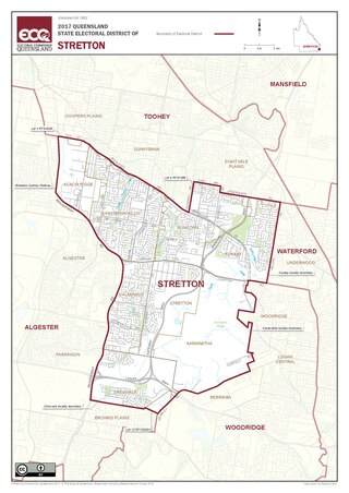
Stretton is an electoral district of the Legislative Assembly in the Australian state of Queensland.

<span class="mw-page-title-main">Calamvale Ward</span>

The Calamvale Ward is a Brisbane City Council ward covering Calamvale, Algester, Drewvale, Heathwood, Parkinson, Stretton, Larapinta, Karawatha, and part of Forest Lake. The ward has been represented by Angela Owen of the Liberal National Party since its creation in 2016. Calamvale replaced Parkinson Ward, which itself replaced Acacia Ridge Ward.

References

  1. 1 2 3 Australian Bureau of Statistics (27 June 2017). "Parkinson (SSC)". 2016 Census QuickStats. Retrieved 20 October 2018. OOjs UI icon edit-ltr-progressive.svg
  2. "Calamvale Ward". Brisbane City Council. Archived from the original on 4 February 2017. Retrieved 12 March 2017.
  3. 1 2 3 "Parkinson – suburb in City of Brisbane (entry 47597)". Queensland Place Names. Queensland Government . Retrieved 26 January 2020.
  4. "Parkinson". Queensland Places. Centre for the Government of Queensland, University of Queensland. Archived from the original on 21 March 2015. Retrieved 17 May 2015.
  5. "Hail storms lash southeast Queensland, killing one and causing flash flooding, havoc on roads". The Courier Mail. 14 October 2011. Archived from the original on 22 May 2022. Retrieved 12 October 2021.
  6. 1 2 Australian Bureau of Statistics (31 October 2012). "Parkinson (Brisbane City) (State Suburb)". 2011 Census QuickStats. Retrieved 28 February 2008. OOjs UI icon edit-ltr-progressive.svg
  7. 1 2 "State and non-state school details". Queensland Government. 9 July 2018. Archived from the original on 21 November 2018. Retrieved 21 November 2018.
  8. "The Spot Academy". The Spot Academcy. Archived from the original on 20 April 2020. Retrieved 21 November 2018.
  9. "Australian Technology and Agricultural College – Parkinson". Archived from the original on 31 October 2018. Retrieved 21 November 2018.
  10. "Mission & Vision". Australian Technology and Agricultural College. Archived from the original on 20 April 2020. Retrieved 20 April 2020.
  11. "Queensland Globe". State of Queensland . Retrieved 20 April 2020.