As at 2008, Zillmere was approximately 60% residential and 40% industrial.[5]
History
The Turrbal people occupied the region north of Brisbane River, including the area covered by Zillmere.[citation needed]
With European settlement, the area came to be known as Zillman's Waterholes, named after Johann Leopold Zillmann (1813–1892), a Lutheran missionary who served at the mission station nearby at Nundah. In January 1872, the Brisbane Courier described Zillman's Waterholes as being situated between Cabbage Tree Creek and Downfall Creek. It was settled with twenty-seven small farmers residing on the land. At the time there were "two chapels, a brickyard and pottery". The settlers grew pineapples, pigs and other small crops.[6]
Zillman's Waterholes State School opened on 22 January 1877. On 8 March 1888, it was renamed Zillmere State School.[8][9]
The Zillman's Waterholes congregation of the Church of Christ formed in 1882, worshipping in the Zillmere German Baptist chapel until they opened their own timber chapel in May 1894.[10][11][12]
After the North Coast Railway Line was extended to Petrie in 1888, the railway station servicing the area was named Zillmere. By the time the first housing estate was marketed in 1897, the area was also being called Zillmere.
St Matthais's Anglican Church was opened in 1895. It was built from timber. In 1964, it was demolished to build a new church.[14] The current St Matthias' Anglican Church was built in 1965. It was built in brick to seat 200 people.[15][16]
A slaughterhouse and curing works was established in 1898 by J.C. Hutton Pty Ltd to slaughter and process pigs from regional farms.[17]
Zillmere in the 1950s showing State Housing Commission Projects and migrant barracks
In June 1917, 140 building sites and 3 substantial houses of "Show Ground Estate Zillmere" were auctioned by G. H. Blocksidge & Ferguson Auctioneers. A map advertising the auction states the Estate was 3 minutes walk from Zillmere Railway Station.[18][19]
In May 1920, 90 subdivided allotments of "Pioneer Estate" were advertised to be auctioned by Isles Love & Co. Auctioneers. A map advertising the auction states the estate was close to Zillmere railway station and fronting Sandgate Road.[20]
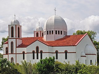
On Sunday 25 June 1933, ArchbishopJames Duhig laid the foundation stone for St Dympna's Catholic Church.[21] Duhig returned on Sunday 17 September 1933 to officially open the church.[22][23] This church is now within the suburb boundaries of Aspley.[23]
During the 1950s, the Housing Commission[24] reclaimed farmland to construct prefabricated houses imported from France. This established Zillmere as a suburban centre. Migrant barracks near Church Road were used to resettle post-war European immigrants until they were destroyed by fire in the mid-1950s.[citation needed]
Northpine Christian College opened in Zillmere in 1953 as a primary school, but the school building was destroyed in a fire in February 1978, resulting in its relocation to Dakabin.[28]
St Flannan's Catholic School opened within the church building on 29 March 1954. The school was operated by the Holy Spirit Sisters with Sisters Delores, Coreen, Elaine and Lorraine teaching the 132 children (91 girls and 41 boys) who enrolled. St Flannan's Catholic Church and School were officially dedicated by ArchbishopJames Duhig in November 1954.[29][30] It was built from timber.[31] For the first four years, the school operated within the church without partitions between the classes, until the first purpose-built school buildings were constructed.[8][32]
Zillmere North State School opened on 29 January 1957. Circa 1995, it was renamed Taigum State School as it is now within the suburb boundaries of neighbouring Taigum.[8]
In the 2011 census, Zillmere had a population of 8,105 people, 51.2% female and 48.8% male. The median age of the Zillmere population was 34 years, 3 years below the Australian median. 67.1% of people living in Zillmere were born in Australia, compared to the national average of 69.8%; the next most common countries of birth were New Zealand 4.8%, India 3.3%, U.K. 2.8%, Philippines 1.7%, Italy 0.7%. 77.5% of people spoke only English at home; the next most common languages were 1.4% Punjabi, 1.1% Samoan, 0.9% Tagalog, 0.8% Karen, 0.8% Cantonese.[39]
In the 2016 census, Zillmere had a population of 8,967 people.[40]
In the 2021 census, Zillmere had a population of 9,323 people.[1]
Heritage listings
There are a number of heritage-listed sites in the suburb, including:
110 Church Road: former St John's Lutheran Church (also known as Christadelphian Church Hall)[41]
The word Zillmere can be broken into two parts Zill and mere. The first part of the conjugation is the first part of Zillmann meaning Sail maker in old German dialects. Spelling variations of this family name include: Zyll, Zyl, Zeil, Ziel, Zyller, Zyllmann, Zillmann, Zylhoffer. The word mere is recorded in Old English, corresponding to Old Saxon meri, Old Low Franconian *meri (Dutch meer), Old High German mari / meri (German Meer), Goth. mari-, marei, Old Norse marr (Swedish mar-, French mare). They derive from reconstituted Germanic *mari, itself from Indo-European *mori, the same root as marsh and moor. The Indo-European root gave also birth to similar words in the other European languages: Latin mare 'sea' (Italian mar", French mer), Old Celtic *mori 'sea' (Gaulish mori-, more, Irish muir, Welsh môr, Breton mor), Old Slavic morje.[52][53] Therefore, Zillmere is the conjugation for Zillman's Waterholes, which were in turn named after early German pioneer Leopold Zillman.[4]
There are no secondary schools in Zillmere. The nearest government secondary school is Aspley State High School in neighbouring Aspley to the west.[58]
The Brisbane City CouncilLibrary service operate the Zillmere Public Library. The library is located on the corner of Jennings Street and Zillmere Road.[59]
Zillmere is also home to a local Parkrun which is run every Saturday morning at the North Star Football club grounds.[67]
Related Research Articles
Sandgate is a northern coastal suburb in the City of Brisbane, Queensland, Australia. In the 2021 census, Sandgate had a population of 4,926 people.
Aspley is a suburb in the City of Brisbane, Queensland, Australia. In the 2021 census, Aspley had a population of 12,871 people.
Geebung is a suburb in the City of Brisbane, Queensland, Australia. In the 2021 census, Geebung had a population of 4,850 people.
Chermside is a suburb in the City of Brisbane, Queensland, Australia. The suburb is situated 9.8 kilometres (6.1 mi) by road north of the Brisbane CBD. It is home to a large Westfield shopping centre. In the 2021 census, Chermside had a population of 11,426 people.
West End is an inner southern suburb in the City of Brisbane, Queensland, Australia. In the 2021 census, West End had a population of 14,730 people.
Chermside West is a suburb in the City of Brisbane, Queensland, Australia. In the 2021 census, Chermside West had a population of 6,965 people. Parts of Chermside West were formerly known as Craigslea.
Holland Park is a southern suburb in the City of Brisbane, Queensland, Australia. In the 2021 census, Holland Park had a population of 8,671 people.
Rocklea is a southern suburb in the City of Brisbane, Queensland, Australia. In the 2021 census, Rocklea had a population of 1,672 people.
Camp Hill is a suburb in the City of Brisbane, Queensland, Australia. In the 2021 census, Camp Hill had a population of 12,254 people.
Boondall is a northern suburb in the City of Brisbane, Queensland, Australia. In the 2021 census, Boondall had a population of 9,603 people.
Wynnum is a coastal suburb in the City of Brisbane, Queensland, Australia. The suburb is a popular destination in Brisbane due to its coastline, jetty and tidal wading pool. In the 2021 census, Wynnum had a population of 14,036 people. Wynnum and the adjoining suburb Manly were once known as twin towns.
Petrie Terrace is an inner suburb in the City of Brisbane, Queensland, Australia. In the 2021 census, Petrie Terrace had a population of 1,168 people.
Hendra is a suburb of the City of Brisbane, Queensland, Australia. In the 2021 census, Hendra had a population of 4,914 people.
Banyo is a northern suburb in the City of Brisbane, Queensland, Australia. In the 2021 census, Banyo had a population of 6,105 people.
Taigum is a northern suburb in the City of Brisbane, Queensland, Australia. In the 2021 census, Taigum had a population of 7,801 people.
Northgate is a suburb in the City of Brisbane, Queensland, Australia. In the 2021 census, Northgate had a population of 4,876 people.
Virginia is a suburb in the City of Brisbane, Queensland, Australia. In the 2021 census, Virginia had a population of 2,395 people.
Nudgee is a north-eastern suburb in the City of Brisbane, Queensland, Australia. In the 2021 census, Nudgee had a population of 4,377 people.
Deagon is an outer northern suburb in the City of Brisbane, Queensland, Australia. In the 2021 census, Deagon had a population of 3,773 people.
Alberton is a rural locality in the City of Gold Coast, Queensland, Australia. In the 2021 census, Alberton had a population of 547 people.
↑ "ZILLMAN'S WATERHOLES". The Brisbane Courier. Vol.XXVI, no.4, 464. Queensland, Australia. 20 January 1872. p.6. Archived from the original on 21 March 2022. Retrieved 17 December 2021– via National Library of Australia.
1 2 Blake, Thom. "St John's Lutheran Church". Queensland religious places database. Archived from the original on 17 March 2022. Retrieved 22 September 2022.
↑ "History". Zillmere State School. 5 February 2020. Archived from the original on 6 March 2022. Retrieved 21 March 2022.
↑ Haigh, George; Churches of Christ in Queensland (1983), Churches of Christ in Queensland: 100 years venturing in faith, Historical Committee, Conference of Churches of Christ in Queensland, p.107, ISBN978-0-909116-38-5
1 2 Blake, Thom. "Zillmere Church of Christ". Queensland religious places database. Archived from the original on 17 March 2022. Retrieved 22 September 2022.
↑ "About Us". ZILLMERE CHURCH. Archived from the original on 25 September 2022. Retrieved 25 September 2022.
↑ "Archbishop Duhig's Views". Queensland Times. Vol.LXXVIII, no.14, 546. Queensland, Australia. 26 June 1933. p.8. Archived from the original on 16 December 2021. Retrieved 17 December 2021– via National Library of Australia.
↑ "FINE GROWTH". The Courier-mail. No.19. Queensland, Australia. 18 September 1933. p.18. Archived from the original on 16 December 2021. Retrieved 17 December 2021– via National Library of Australia.
↑ Blake, Thom. "Zillmere Salvation Army". Queensland religious places database. Archived from the original on 23 March 2022. Retrieved 22 September 2022.
↑ "Our History". Northpine Christian College. Archived from the original on 19 April 2021. Retrieved 11 December 2021.
↑ "Saw city expansion". The Courier-mail. Queensland, Australia. 29 November 1954. p.7. Archived from the original on 25 September 2022. Retrieved 25 September 2022– via National Library of Australia.
↑ "History". St Flannan's Catholic School. Archived from the original on 4 March 2022. Retrieved 21 March 2022.
↑ Blake, Thom. "Zillmere Presbyterian Church". Queensland religious places database. Archived from the original on 25 September 2022. Retrieved 22 September 2022.
This page is based on this Wikipedia article Text is available under the CC BY-SA 4.0 license; additional terms may apply. Images, videos and audio are available under their respective licenses.