Belmont, Queensland

Last updated

Belmont
Brisbane,  Queensland
Stanbrough Road Belmont.jpg
Stanbrough Road, 2014
Australia Queensland location map.svg
Red pog.svg
Belmont
Belmont, Queensland
Coordinates 27°30′21″S153°08′07″E / 27.5058°S 153.1352°E / -27.5058; 153.1352 (Belmont (centre of suburb))
Population4,374 (2016 census) [1]
 • Density437.4/km2 (1,133/sq mi)
Established1894
Postcode(s) 4153 [2]
Area10.0 km2 (3.9 sq mi)
Time zone AEST (UTC+10:00)
Location13.0 km (8 mi) ESE of Brisbane GPO
LGA(s) City of Brisbane
(Chandler Ward; [3] Doboy Ward) [4]
State electorate(s) Chatsworth
Federal division(s) Bonner
Suburbs around Belmont:
Carina Tingalpa Wakerley
Carindale Belmont Gumdale
Carindale Mackenzie Chandler

Belmont is an outer suburb in the City of Brisbane, Queensland, Australia. [5] In the 2016 census, Belmont had a population of 4,374 people. [1]

Contents

Geography

While much of the suburb remains as undeveloped blocks of bush mixed with large rural properties, some areas have built-up residential estates.[ citation needed ]

Two of Brisbane's main roads, the Gateway Motorway above and Old Cleveland Road underneath, cross at a large intersection in Belmont. Belmont has become an affluent suburb with large estates sitting on acres of land. Homes can range from around 3,500 square feet (330 m2) to 10,000 square feet (930 m2) and over.[ citation needed ]

Mount Petrie is in the south of the suburb ( 27°31′30″S153°08′07″E / 27.5249°S 153.1353°E / -27.5249; 153.1353 (Mount Petrie) ) and rises to 169 metres (554 ft) above sea level. [6] [7]

History

The local indigenous people hunted and camped within the creeks and hills of Belmont, both before and after white settlement of the area. A corroboree ground existed on banks of Bulimba Creek and mineral springs near Mount Petrie were a popular camping spot for the Aboriginal people.[ citation needed ]

Andrew Petrie had reported that fine timber existed in the area.[ citation needed ] Mount Petrie is named after him. [7]

The suburb takes its name from Belmont House, built circa 1860 by Colonel August Bernecker. [8] The name is derived from the French Bellemont meaning beautiful mountain. [5] August Charles Frederick Bernecker gave the name Belmont to his new estate outside of Brisbane and this name spread to the rest of the area. [9]

The Hoop Pine brought timber cutters to the area in the 1850s and by the 1860s and 1870s the cleared land near the creeks and the rich soils from the cleared forests were used to grow sugar cane. As sugar production declined in southern Queensland, farmers moved to growing pineapples, bananas and small crops including tomatoes, potatoes and grapes. Dairies and fodder farms were also located in the area.[ citation needed ]

Belmont State School opened on 5 June 1876. [10] [11] It is now within the suburb boundaries of Carindale. [12] San Sisto Secondary College opened in Belmont on 1 February 1961; it is now within the suburb boundaries of Carina [13]

The Grassdale Land Company Limited formed on 8 January 1885 to acquire the property known as Grassdale Paddocks, in the parish of Tingalpa, with registered shareholders holding 80 shares of 250 pounds each. [14] This area is spread across the Brisbane suburbs of Belmont, Chandler and Gumdale. The company offered the land for auction in the Grassdale Estate later in 1885. [15] The allotments were situated along Grassdale Road, London Road, Boston Road, Old Cleveland Road, Archer Street and four unnamed roads (later called Belmont Road, Stanborough Road, Tilley Road and New Cleveland Road). Prior to the sale extensive publicity was published in the Brisbane newspapers, calling for "the attention of the investor, capitalist, farmer, merchant, artizan [sic], and mechanic, and is only one hour's drive from Brisbane, and as it has been decided to run the Cleveland Railway through the Estate, it will be brought within a few minutes' ride of the heart of the city". [16] The results of the public auction on 28 November 1885 were reported in the Telegraph newspaper with "forty-two lots were disposed of, comprising an area of 144 acres..." [17] The Grassdale Land Company Limited later produced a plan of divisions of unsold land into 45 lots, listing the size and value of the lots at the time. [18]

The local government area Belmont Division was split from the Bulimba Division in 1894 and by 1901 this became the Belmont Shire. Belmont Shire was a larger area than Belmont today with parts now included in the suburb of Carindale and other suburbs. [13]

In August 1948, the Belmont tram line extension was opened. [13]

From 25 May 1912, the Belmont Shire Council operated the Belmont Tramway, a 3-foot 6 inches (1,067 mm) gauge steam tramway from Norman Park railway station to a terminus near the present State School. [19] The line closed following the amalgamation of Shire into the City of Greater Brisbane in 1925.

Demographics

In the 2011 census, Belmont recorded a population of 4,594 people. [20] The population was 50.5% female and 49.5% male. [1] The median age of the Belmont population was 38 years of age. 72.6% of people living in Belmont were born in Australia, compared to the national average of 66.7%; the next most common countries of birth were New Zealand 5.2%, England 2.9%, China 1.7%, South Africa 1.3%, India 1.2%. 79.7% of people spoke only English at home; the next most popular languages were 2.3% Mandarin, 1.7% Greek, 1.4% Spanish, 1.2% Cantonese, 1.1% Italian. [20]

In the 2016 census, Belmont had a population of 4,374 people. [1]

Education

There are no schools within Belmont. [21] Despite the name, Belmont State School is now within the current boundaries of Carindale. [22]

The nearest government primary schools are Tingalpa State School in neighbouring Tingalpa to the north, Gumdale State School in neighbouring Gumdale to the north-east and Belmont State School in neighbouring Carindale to the west. The nearest government secondary schools are Brisbane Bayside State College in Wynnum West to the north-east, Whites Hill State College in Camp Hill to the west, and Mansfield State High School in Mansfield to the south-west. [21]

Amenities

The Belmont Rifle Range ( 27°30′37″S153°08′01″E / 27.5103°S 153.1335°E / -27.5103; 153.1335 (Belmont Rifle Range) ) hosts a number of sport shooting clubs. [23] It was the venue for shooting events for the 1982 Commonwealth Games and 2018 Commonwealth Games, [24] [25] and site of the 2011 World Long Range Championships. To the south of the rifle range is Mount Petrie.

Parks

There are a number of parks in the suburb, including:

See also

Related Research Articles

<span class="mw-page-title-main">Mount Cotton, Queensland</span> Locale in Queensland, Australia

Mount Cotton is a rural locality in the City of Redland, Queensland, Australia. In the 2016 census, Mount Cotton had a population of 6,835 people.

<span class="mw-page-title-main">Bulimba Creek</span> River in Queensland, Australia

Bulimba Creek, originally known as Doboy Creek or Doughboy Creek, is a perennial stream that is a tributary of the Brisbane River, located in suburban Brisbane in the South East region of Queensland, Australia.

<span class="mw-page-title-main">Capalaba, Queensland</span> Suburb of Redland City, Queensland, Australia

Capalaba is an urban locality in the City of Redland, Queensland, Australia. In the 2021 census, Capalaba had a population of 18,002 people.

<span class="mw-page-title-main">Tingalpa, Queensland</span> Suburb of Brisbane, Queensland, Australia

Tingalpa is a suburb in the City of Brisbane, Queensland, Australia. In the 2016 census, Tingalpa had a population of 8,290 people.

<span class="mw-page-title-main">Carina, Queensland</span> Suburb of Brisbane, Queensland, Australia

Carina is a suburb in the City of Brisbane, Queensland, Australia. In the 2016 census, Carina had a population of 11,019 people.

<span class="mw-page-title-main">New Farm, Queensland</span> Suburb of Brisbane, Queensland, Australia

New Farm is an inner northern riverside suburb in the City of Brisbane, Queensland, Australia. In the 2021 census, New Farm had a population of 12,454 people.

<span class="mw-page-title-main">Rocklea, Queensland</span> Suburb of Brisbane, Queensland, Australia

Rocklea is a suburb in the City of Brisbane, Queensland, Australia. In the 2016 census, Rocklea had a population of 1,595 people.

<span class="mw-page-title-main">Camp Hill, Queensland</span> Suburb of Brisbane, Queensland, Australia

Camp Hill is a suburb in the City of Brisbane, Queensland, Australia. In the 2021 census, Camp Hill had a population of 12 145 people.

<span class="mw-page-title-main">Carindale, Queensland</span> Suburb of Brisbane, Queensland, Australia

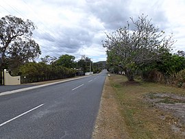
Carindale is a suburb of the City of Brisbane, Queensland, Australia. It is located 13.1 kilometres (8.1 mi) by road south-east of the Brisbane GPO, and borders Belmont, Carina, Carina Heights, Mackenzie, Mansfield, Mount Gravatt East, and Tingalpa. In the 2021 census, Carindale had a population of 16,535 people.

<span class="mw-page-title-main">Seven Hills, Queensland</span> Suburb of Brisbane, Queensland, Australia

Seven Hills is a suburb in the City of Brisbane, Queensland, Australia. In the 2021 census, Seven Hills had a population of 2,732 people.

<span class="mw-page-title-main">Mackenzie, Queensland</span> Suburb of City of Brisbane, Queensland, Australia

Mackenzie is a south-eastern suburb in the City of Brisbane, Queensland, Australia. In the 2016 census, Mackenzie had a population of 2,094 people.

<span class="mw-page-title-main">Petrie Terrace, Queensland</span> Suburb of Brisbane, Queensland, Australia

Petrie Terrace is an inner suburb in the City of Brisbane, Queensland, Australia. In the 2016 census, Petrie Terrace had a population of 1,124 people.

<span class="mw-page-title-main">Burbank, Queensland</span> Suburb of Brisbane, Queensland, Australia

Burbank is a greenbelt suburb in the City of Brisbane, Queensland, Australia. In the 2016 census, Burbank had a population of 1,050 people.

<span class="mw-page-title-main">Thorneside, Queensland</span> Suburb of Redland City, Queensland, Australia

Thorneside is a coastal urban locality in the City of Redland, Queensland, Australia. In the 2016 census, Thorneside had a population of 3,761 people.

<span class="mw-page-title-main">Chandler, Queensland</span> Suburb of Brisbane, Queensland, Australia

Chandler is an outer south-eastern suburb in the City of Brisbane, Queensland, Australia. In the 2016 census, Chandler had a population of 1,442 people.

<span class="mw-page-title-main">Gumdale, Queensland</span> Suburb of Brisbane, Queensland, Australia

Gumdale is an outer suburb of the City of Brisbane, Queensland, Australia. In the 2016 census, Gumdale had a population of 2,118 people.

<span class="mw-page-title-main">Hemmant, Queensland</span> Suburb of Brisbane, Queensland, Australia

Hemmant is a suburb of the City of Brisbane, Queensland, Australia. In the 2016 census, Hemmant had a population of 2,385 people.

<span class="mw-page-title-main">Ransome, Queensland</span> Suburb of Brisbane, Queensland, Australia

Ransome is an outer coastal suburb in the City of Brisbane, Queensland, Australia. In the 2016 census, Ransome had a population of 405 people.

<span class="mw-page-title-main">Carina Heights, Queensland</span> Suburb of Brisbane, Queensland, Australia

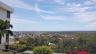
Carina Heights is both a hill and a suburb in the City of Brisbane, Queensland, Australia. In the 2016 census, Carina Heights had a population of 6,732 people.

<span class="mw-page-title-main">Shire of Belmont</span> Former local government area in Queensland

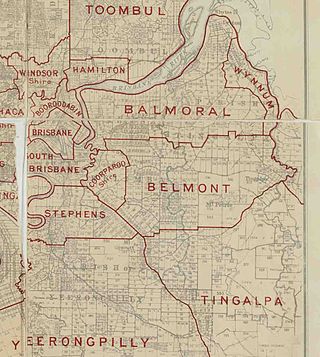
The Shire of Belmont is a former local government area of Queensland, Australia, located in eastern Brisbane including the current suburb of Belmont.

References

  1. 1 2 3 4 Australian Bureau of Statistics (27 June 2017). "Belmont (SSC)". 2016 Census QuickStats. Retrieved 20 October 2018. OOjs UI icon edit-ltr-progressive.svg
  2. "Find a postcode". Australia Post. Archived from the original on 24 August 2011. Retrieved 4 January 2014.
  3. "Chandler Ward". Brisbane City Council. Archived from the original on 4 February 2017. Retrieved 12 March 2017.
  4. "Doboy Ward". Brisbane City Council. Archived from the original on 14 June 2018. Retrieved 12 March 2017.
  5. 1 2 "Belmont – suburb in City of Brisbane (entry 49637)". Queensland Place Names. Queensland Government . Retrieved 26 December 2020.
  6. "Mountain peaks and capes – Queensland". Queensland Open Data. Queensland Government. 12 November 2020. Archived from the original on 25 November 2020. Retrieved 25 November 2020.
  7. 1 2 "Mount Petrie – mountain in Brisbane City (entry 26541)". Queensland Place Names. Queensland Government . Retrieved 25 November 2020.
  8. "Station, Farm, and Garden". The Queenslander . Vol. IX, no. 49. Queensland, Australia. 9 January 1875. p. 5. Archived from the original on 31 May 2022. Retrieved 15 April 2021 via National Library of Australia.
  9. "Belmont (entry 42561)". Queensland Place Names. Queensland Government . Retrieved 16 April 2014.
  10. Queensland schools past and present. Version 1.01. Queensland Family History Society. 2010. ISBN   978-1-921171-26-0.
  11. "Our school". Belmont State School. 8 April 2020. Archived from the original on 29 March 2022. Retrieved 31 May 2022.
  12. "Queensland Globe". State of Queensland . Retrieved 31 May 2022.
  13. 1 2 3 "Belmont". State Library of Queensland. 12 November 2008. Retrieved 31 August 2023.
  14. "The Brisbane Courier". The Brisbane Courier . Vol. XXXIX, no. 8, 426. Queensland, Australia. 12 January 1885. p. 4. Archived from the original on 21 May 2022. Retrieved 30 July 2019 via National Library of Australia.
  15. "Grassdale Estate 2nd section" (c. 1880) [Map]. Collections. State Library of Queensland.
  16. "Advertising". Queensland Figaro And Punch . Vol. VI, no. 150. Queensland, Australia. 21 November 1885. p. 39. Archived from the original on 21 May 2022. Retrieved 30 July 2019 via National Library of Australia.
  17. "Commercial". The Telegraph . No. 4, 125. Queensland, Australia. 30 November 1885. p. 4. Archived from the original on 21 May 2022. Retrieved 30 July 2019 via National Library of Australia.
  18. "Plan of divisions of unsold land into 45 lots [between Old and New Cleveland Roads]" [Map]. Collections. State Library of Queensland.
  19. Australian Railway Historical Society Bulletin, April 1959 pp49-52
  20. 1 2 Australian Bureau of Statistics (31 October 2012). "Belmont, Qld (State Suburb)". 2011 Census QuickStats. Retrieved 10 October 2013. OOjs UI icon edit-ltr-progressive.svg
  21. 1 2 "Queensland Globe". State of Queensland . Retrieved 15 April 2021.
  22. "Belmont State School". Belmont State School. 8 April 2020. Archived from the original on 15 April 2021. Retrieved 15 April 2021.
  23. "About Us". Belmont Range. Archived from the original on 16 April 2014. Retrieved 15 April 2014.
  24. "GC2018 aims to leave lasting legacy for Queensland sporting shooters". Ministerial Media Statements. Retrieved 31 August 2023.
  25. "Belmont Shooting Complex Brisbane". Belmont Shooting Complex Brisbane. Retrieved 31 August 2023.
  26. 1 2 3 4 5 6 7 8 9 10 11 12 13 14 15 "Land for public recreation – Queensland". Queensland Open Data. Queensland Government. 20 November 2020. Archived from the original on 22 November 2020. Retrieved 22 November 2020.