St Lucia is a riverside suburb in the City of Brisbane, Queensland, Australia.[3] The University of Queensland is the main attraction of St Lucia, with the university and its residential colleges covering a large proportion of the suburb. According to the 2021 census, St Lucia had a population of 12,220 people.[1]
St Lucia is located 7.3 kilometres (4.5mi) by road southwest of the Brisbane GPO.[4] The suburb sits on a peninsula, bounded on the north, east and south by the median in a bend of the Brisbane River.[5] The eastern third of the suburb is occupied by the main campus of the University of Queensland. The flatter area on the northern side is primarily medium to high density residential, including some high-rise apartments on the riverfront. The more hilly area in the centre and south is mainly low-density, family-occupied residential. The south-west is occupied by the St Lucia Golf Links.
The area was originally part of Indooroopilly and later became a part of Toowong. Initially known as Indooroopilly Pocket, it was briefly called Toowong South before a portion of the area was separated and named as Lang Farm.
Sugar plantations were established in the area in the 1860s. In 1982, William Alexander Wilson, who was born in St Lucia in the West Indies, purchased the Coldridge Plantation and renamed it St Lucia Sugar Plantation. The plantation was subdivided for housing in 1883, and the name was transferred to the subdivision.[14]
Toowong Mixed State School opened on 10 October 1870. It was renamed Indooroopilly State School in 1879, and then Indooroopilly Pocket State School in 1888. In October 1904, it was renamed Ironside State School after the neighbouring estate of John Dunmore Lang.[15][16]
Demographics
According to the 2021 census, St Lucia had a population of 12,220 people, with a gender distribution of 49.3% male and 50.7% female. This gender distribution closely mirrors the national average.[1]
The median age in St Lucia was 25 years, significantly younger than the Australian median of 38 years. Children under 15 years comprised 10.7% of the population, while those aged 65 and over made up 10.9%. Notably, 38.2% of St Lucia’s population was aged between 15 and 24 years, compared to 12.4% nationally.[1]
In terms of birthplace, 54.5% of St Lucia residents were born in Australia, compared to 66.9% nationally. The next most common countries of birth were China (7.4%), England (3.0%), India (2.8%), Malaysia (2.6%), and New Zealand (1.8%).[1]
Regarding language, 63.1% of people spoke only English at home, compared to 72.0% nationally. Other most commonly spoken languages included Mandarin (10.1%), Cantonese (1.7%), Spanish (1.5%), Bengali (1.3%), and Vietnamese (1.2%).[1]
When it came to religion, the most common response was "no religion" (47.8%), compared to 38.4% nationally. Other most common religions were Catholicism (14.4%), Anglicanism (7.7%), and Islam (4.7%).[1]
In the 2016 census, St Lucia had a population of 12,574 people.[17]
In the 2011 census, St Lucia had a population of 11,195 people.[18]
Although never heritage-listed, one of St Lucia's most iconic homes was the so-called "The Pink Palace" at 272 Swann Road until it was demolished in 2016.[24][25]
St Lucia hosts the main campus of the University of Queensland, a public research university. The campus spans much of this riverside inner suburb. As of 2024, the University has 7,504 full-time equivalent staff members, and in 2023, the total number of students was 55,424.[31]
Amenities
Several small shopping precincts are located throughout the suburb, but it is primarily residential. The main precinct is a strip of stores along Hawken Drive. This strip includes a local IGA Supermarket, various international restaurants, a medical centre, dentist office, and a post office/news agency. Friday nights are particularly popular for dining out, as many residents enjoy eating at these restaurants.[32][33]
St Lucia is home to several places of worship, including St Lucia Uniting Church (7 Hawken Drive),[34] St Thomas Aquinas Catholic Church (87 Central Avenue),[35] St Lucia Evangelical Church, part of the Chinese Christian Church Brisbane (83 Ryans Road),[36] and Christ Church St Lucia, part of the Anglican Church of Southern Queensland (9 Ninth Avenue).[37] The University of Queensland have a multi-faith chaplaincy service. It offers an inclusive space for students, staff, and the wider University of Queensland community from various faiths.[38]
St Lucia Golf Links, St Lucia
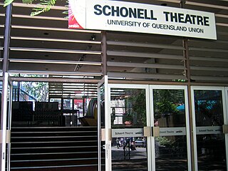
The Schonell Theatre hosts many performances that the members of the public can attend by purchasing tickets.[39] The theatre, built in 1970 and refurbished in 2005, is owned and managed by the University of Queensland Union (UQU). In 2019, the theatre was planned for demolition as part of the UQU Complex redevelopment plan. However, in 2022, the demolition plans were abandoned due to a lack of community support.[40][41]
The Avalon Theatre, built in the 1920s, has served the St Lucia community as a church hall, community hall, and cinema. The University of Queensland acquired the property in February 1963. By 1975, the building was repurposed as a teaching space.[42] Although it was closed in 2004 due to its age,[43] the theatre was restored and reopened in July 2024, now offering space for students, staffs, and eventually clubs, societies, and the wider community.[44]
There are 15 parks in St Lucia, many with seating facilities, playground, and picnic area. Carawa Street Park has a dog off-leash area.[45] These parks are maintained by the Brisbane City Council.[46]
Sports
St Lucia Golf Links is an 18-hole pay-and-play public golf course located at the corner of Indooroopilly Road and Carawa Street. The golf course is one of Brisbane's oldest and has hosted several Queensland Open and PGA tournaments. The course layout accommodates golfers of all skill levels.[47]
St Lucia Bowls Club, situated at 9 Carr Street near the University of Queensland, was established in 1947.[48] The club features two bowling greens and offers a variety of men's, women's, and mixed competitions. Additionally, it participates in several inter-club events, including District Pennants.[49]
Toowong Rowing Club, established in 1889, was originally based in Toowong. After multiple relocations due to floods, it finally settled at 37 Keith Street, St Lucia, in 1976. The club boasts a diverse membership, including juniors, high-performance athletes, veterans, honorary life members, recreational rowers, and social members.[50]
The University of Queensland provides public access to its swimming pools, tennis courts, and other amenities, although some facilities require a fee.[51][52]
Events
Every Saturday morning at 7 a.m., the free St Lucia 5km parkrun takes place near the University of Queensland, opposite the UQ Aquatics Centre on Sir William Macgregor Drive.[53]
Transport
Guyatt Park Ferry Terminal, St LuciaEleanor Schonell Bridge
The University of Queensland is a public research university located primarily in Brisbane, the capital city of the Australian state of Queensland. Founded in 1909 by the Queensland parliament, UQ is one of the six sandstone universities, an informal designation of the oldest university in each state. UQ is also a founding member of edX, Australia's leading Group of Eight and the international research-intensive Association of Pacific Rim Universities.
Toowong is a riverside suburb in the City of Brisbane, Queensland, Australia. In the 2021 census, Toowong had a population of 12,556 people with a median weekly household income of $1,927.
Chapel Hill is a western suburb in the City of Brisbane, Queensland, Australia. In the 2021 census, Chapel Hill had a population of 10,511 people.
Dutton Park is an inner southern suburb in the City of Brisbane, Queensland, Australia. In the 2021 census, Dutton Park had a population of 2,134 people.
Jindalee is a south-western residential suburb in the City of Brisbane, Queensland, Australia. In the 2021 census, Jindalee had a population of 5,320 people.
Taringa is a suburb in the City of Brisbane, Queensland, Australia. In the 2021 census, Taringa had a population of 8,732 people.
Indooroopilly is a riverside suburb 7.8 kilometres (4.8 mi) south-west of the Brisbane CBD, Queensland, Australia. In the 2021 census, Indooroopilly had a population of 13,622 people.
Brookfield is a rural residential suburb in the City of Brisbane, Queensland, Australia. In the 2021 census, Brookfield had a population of 3,640 people.
The Eleanor Schonell Bridge, better known as the Green Bridge, is a 390-metre (1,280 ft)-long cable-stayed bridge which crosses the Brisbane River between Dutton Park and the University of Queensland's St Lucia campus, connecting the UQ Lakes and Dutton Park Place busway stations. Its deck is 185 metres long, 20 metres wide and about 18 metres above the river's surface. The bridge was opened on 17 December 2006, and is the first bridge in Australia exclusively designed for buses, cyclists and pedestrians. The bridge cost $55.5 million to construct.
Chelmer is a south-western suburb in the City of Brisbane, Queensland, Australia. In the 2021 census, Chelmer had a population of 3,325 people.
The Schonell Cinema & Live Theatre is a venue for theatre, special events and cinema screenings in Brisbane, Australia. It consists of Theatre One: a 420-seat, single auditorium theatre capable of hosting musical performances, plays and lectures and Cinema 2, a 175-seat cinema suitable for exclusive screenings, presentations and small performances.
UQ St Lucia ferry wharf is located on the southern side of the Brisbane River serving the Brisbane suburb of St Lucia in Queensland, Australia. It is served by RiverCity Ferries' CityCat services.
Auchenflower is an inner western riverside suburb of the City of Brisbane, Queensland, Australia. In the 2021 census, Auchenflower had a population of 6,053 people.
Red Hill is an inner northern suburb in the City of Brisbane, Queensland, Australia. In the 2021 census, Red Hill had a population of 5,834 people.
Graceville is a suburb in the City of Brisbane, Queensland, Australia. In the 2021 census, Graceville had a population of 4,764 people.
Hamilton is an affluent riverside mixed-use suburb in the north-east of the City of Brisbane, Queensland, Australia. Hamilton is located along the north bank of the Brisbane River. In the 2021 census, Hamilton had a population of 8,922 people.
Jamboree Heights is a south-western suburb in the City of Brisbane, Queensland, Australia. In the 2021 census, Jamboree Heights had a population of 3,141 people.
Riverhills is a south-western suburb in the City of Brisbane, Queensland, Australia. It is one of the Centenary suburbs. In the 2021 census, Riverhills had a population of 4,121 people.
The Shire of Taringa is a former local government area of Queensland, Australia, located in western Brisbane. Its administrative centre was Taringa. It existed from 1890 to 1925.
Ironside State School is a heritage-listed state school at 378 Swann Road, St Lucia, City of Brisbane, Queensland, Australia. It was built from 1935 to 1959. It was added to the Queensland Heritage Register on 27 July 2018.
This page is based on this Wikipedia article Text is available under the CC BY-SA 4.0 license; additional terms may apply. Images, videos and audio are available under their respective licenses.