Sherwood, Queensland

Last updated

Map all coordinates using: OpenStreetMap  
Sherwood
Brisbane,  Queensland
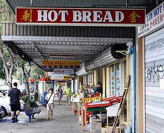
Sherwood Queensland.jpg
Sherwood Central shops on Sherwood Road
Australia Queensland location map.svg
Red pog.svg
Sherwood
Coordinates 27°31′53″S152°58′59″E / 27.5314°S 152.9830°E / -27.5314; 152.9830 (Sherwood (centre of suburb))
Population5,313 (2016 census) [1]
 • Density2,210/km2 (5,730/sq mi)
Postcode(s) 4075
Area2.4 km2 (0.9 sq mi)
Time zone AEST (UTC+10:00)
Location11.4 km (7 mi) SW of Brisbane GPO
LGA(s) City of Brisbane
(Tennyson Ward) [2]
State electorate(s)
Federal division(s) Moreton
Suburbs around Sherwood:
Fig Tree Pocket Graceville Tennyson
Fig Tree Pocket Sherwood Rocklea
Fig Tree Pocket Corinda Rocklea

Sherwood is a suburb in the City of Brisbane, Queensland, Australia. [3] In the 2016 census, Sherwood had a population of 5,313 people. [1]

Geography

Sherwood is 8.3 kilometres (5.2 mi) south west of the Brisbane CBD [5] and bounded by the median of the Brisbane River towards the west. [6]

Oxley Road is the main thoroughfare through the suburb, entering from the north (Graceville) and exiting to the south (Corinda). The Ipswich railway line runs parallel to and west of Oxley Avenue, with the suburb served by Sherwood railway station ( 27°31′52″S152°58′46″E / 27.5310°S 152.9795°E / -27.5310; 152.9795 (Sherwood railway station) ). [7]

The suburb is mostly low and medium-density housing with a retail strip centred along Sherwood Road.[ citation needed ]

History

West Oxley State School opened on 25 March 1867. It was renamed Sherwood State School in 1878. [8] [9] The first head teacher was Major William Jenyns Boyd. He was born in Paris in 1842 and migrated to Australia in 1862. In 1868, Oliver Radcliffe was the first name on the roll as a pupil teacher. [10] He became a teacher, a headmaster and then a school inspector. By his retirement in 1932, he was the Chief Inspector for the Queensland Education Department. He personally inspected schools from Coolangatta to Thursday Island and from Rockhampton to the border with South Australia. [11]

In 1879, the local government area of Yeerongpilly Division was created. In 1891 parts of Yeerongpilly Division were excised to create Sherwood Division becoming a Shire in 1903 which contained the suburb of Sherwood. In 1925, the Shire of Sherwood was amalgamated into the City of Brisbane. [12]

On 24 October 1885, auctioneer John F. Buckland offered 268 suburban blocks (mostly 16 perches) in the Township of Sherwood Estate. Most of the blocks were in the area bounded by Oxley Road to the west, Sherwood Road to the north and the Corinda–Yeerongpilly railway line to the south-east. The remaining blocks were south of the railway line on Railway Terrace. [13] [14] However, only about 40 blocks were sold. [15] On 23 June 1888 auctioneer John F. Buckland offered the remaining 200 suburban blocks in the Township of Sherwood Estate. [13] [16]

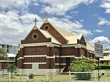
Sherwood Methodist Church was built in 1914. It was designed by Walter Taylor and built from concrete. Following the amalgamation that created the Uniting Church in Australia in 1977, it became known as Sherwood Uniting Church. [17] A Sunday School hall was opened on Saturday 29 June 1918. [18]

On 17 March 1928, Herbert Hoare in conjunction with auctioneer Norman C. Cosssart offered 8 suburban sites in the Sherwood Station Estate, which was bounded by Dewar Terrace to the west, Station Street (now Marlborough Street) to the north and Honour Avenue to the west (and north of Lilly Street). The land was formerly the home of judge Pope Alexander Cooper who died in 1923. [19] [20]

Sherwood was badly flooded in February 1931, January 2011 [21] and February 2022. [22] [23]

Demographics

In the 2016 census, Sherwood had a population of 5,313 people, 52.9% female and 47.1% male. [1] The median age of the Sherwood population was 35 years, three years below the Australian median. 71.2% of people living in Sherwood were born in Australia, similar to the national average of 66.7%. The other top responses for country of birth were England 5.0%, New Zealand 2.5%, India 1.9%, South Korea 0.9%, China (excluding SARs and Taiwan) 0.8%. 82.3% of people spoke only English at home; other languages include 1.3% Mandarin, 1.0% Korean, 0.8% Spanish, 0.7% Persian, 0.7% Hindi. [1]

Heritage listings

Sherwood Arboretum wetlands, 2014 Sherwood Arboretum wetlands.jpg
Sherwood Arboretum wetlands, 2014

Sherwood has a number of heritage-listed sites, including:

Education

Sherwood State School is a government primary (Prep-6) school for boys and girls at 464 Oxley Road ( 27°31′53″S152°59′00″E / 27.5315°S 152.9832°E / -27.5315; 152.9832 (Sherwood State School) ). [44] [45] In 2018, the school had an enrolment of 586 students with 41 teachers (34 full-time equivalent) and 31 non-teaching staff (17 full-time equivalent). [46] The school has preserved many of its historic timber buildings. [34]

There is no secondary school in Sherwood. The nearest government secondary school is Corinda State High School in neighbouring Corinda to the south. [47]

Amenities

Sherwood Road and shops Sherwood Queensland 2.jpg
Sherwood Road and shops

There are a number of cafes, both a BWS and Liquorland liquor store, a fitness center, a Bank of Queensland branch, op shops, and a Woolworths supermarket.

There are a number of churches in Sherwood, including:

Morning fog at Thomas Street Park Morning fog at Thomas Street Park, Sherwood, Queensland 02.jpg
Morning fog at Thomas Street Park

Sherwood contains a few parks in different parts of the suburb. The Sherwood Arboretum is on the western side of the suburb, bordering the Brisbane River. Hives park borders the Ipswich line on the southern end of the suburb, and contains a Girl Guides building. Thomas Street Park and Strickland Terrace Park is on the eastern end of the suburb, bordering the Oxley Creek. The Stewart Franklin Park is a small park on the southern border of the suburb, next to the Tennyson line.

The Sherwood Sharks swimming club uses the Sherwood State School Pool.

Transport

Sherwood railway station, 2017 Platforms at Sherwood railway station, Brisbane 01.jpg
Sherwood railway station, 2017

The suburb is serviced by the Sherwood railway station which links Ipswich and the Springfield Central lines to the Brisbane central business district. Bus services along Oxley Road link the Centenary suburbs to Indooroopilly and the Great Circle Line service passes through the suburb.

Related Research Articles

<span class="mw-page-title-main">Wooloowin, Queensland</span> Suburb of Brisbane, Queensland, Australia

Wooloowin is a suburb in the City of Brisbane, Queensland, Australia. In the 2016 census, Wooloowin had a population of 3,938 people.

<span class="mw-page-title-main">Inala, Queensland</span> Suburb of Brisbane, Queensland, Australia

Inala is a suburb in the City of Brisbane, Queensland, Australia. In the 2016 census, Inala had a population of 14,849 people.

<span class="mw-page-title-main">Toowong</span> Suburb of Brisbane, Queensland, Australia

Toowong is a riverside suburb in the City of Brisbane, Queensland, Australia. In the 2021 census, Toowong had a population of 12,556 people. It is predominantly a middle-class area (67.8%), with a median weekly household income of $1,930.

<span class="mw-page-title-main">Oxley, Queensland</span> Suburb of Brisbane, Queensland, Australia

Oxley is a south-western suburb in the City of Brisbane, Queensland, Australia. In the 2016 census, Oxley had a population of 8,336 people.

<span class="mw-page-title-main">Darra, Queensland</span> Suburb of Brisbane, Queensland, Australia

Darra is a south-western suburb in the City of Brisbane, Queensland, Australia. In the 2016 census, Darra had a population of 4,343 people.

<span class="mw-page-title-main">Taringa, Queensland</span> Suburb of Brisbane, Queensland, Australia

Taringa is a suburb in the City of Brisbane, Queensland, Australia. In the 2016 census, Taringa had a population of 8,376 people.

<span class="mw-page-title-main">Wynnum, Queensland</span> Suburb of Brisbane, Queensland, Australia

Wynnum is a coastal suburb in the City of Brisbane, Queensland, Australia. In the 2016 census, Wynnum had a population of 12,915 people. The suburb is a popular destination in Brisbane due to its coastline, jetty and tidal wading pool.

<span class="mw-page-title-main">Indooroopilly, Queensland</span> Suburb of Brisbane, Queensland, Australia

Indooroopilly is a riverside suburb 7 km west of the Brisbane CBD, Queensland, Australia. In the 2016 census, Indooroopilly had a population of 12,242 people.

<span class="mw-page-title-main">Brookfield, Queensland</span> Suburb of Brisbane, Queensland, Australia

Brookfield is a rural residential suburb in the City of Brisbane, Queensland, Australia. In the 2016 census, Brookfield had a population of 3,524 people.

<span class="mw-page-title-main">Brighton, Queensland</span> Suburb of Brisbane, Queensland, Australia

Brighton is a coastal northern suburb of Brisbane, in the state of Queensland, in Australia. In the 2016 census, Brighton had a population of 9,479 people.

<span class="mw-page-title-main">Chelmer, Queensland</span> Suburb of Brisbane, Queensland, Australia

Chelmer is a south-western suburb in the City of Brisbane, Queensland, Australia. In the 2016 census, Chelmer had a population of 2,998 people.

<span class="mw-page-title-main">Corinda, Queensland</span> Suburb of Brisbane, Queensland, Australia

Corinda is a suburb in the City of Brisbane, Queensland, Australia. In the 2016 census, Corinda had a population of 5,064 people.

<span class="mw-page-title-main">Yeronga, Queensland</span> Suburb of Brisbane, Queensland, Australia

Yeronga is a southern riverside suburb in the City of Brisbane, Queensland, Australia. In the 2016 census, Yeronga had a population of 6,535 people.

<span class="mw-page-title-main">Wacol, Queensland</span> Suburb of Brisbane, Queensland, Australia

Wacol is a suburb in the City of Brisbane, Queensland, Australia. In the 2016 census, Wacol had a population of 3,761 people.

<span class="mw-page-title-main">Graceville, Queensland</span> Suburb of Brisbane, Queensland, Australia

Graceville is a suburb in the City of Brisbane, Queensland, Australia. In the 2016 census, Graceville had a population of 4,634 people.

<span class="mw-page-title-main">Jamboree Heights, Queensland</span> Suburb of Brisbane, Queensland, Australia

Jamboree Heights is a south-western suburb in the City of Brisbane, Queensland, Australia. In the 2016 census, Jamboree Heights had a population of 3,093 people.

<span class="mw-page-title-main">Seventeen Mile Rocks, Queensland</span> Suburb of Brisbane, Queensland, Australia

Seventeen Mile Rocks is a suburb in the City of Brisbane, Queensland, Australia. In the 2016 census, Seventeen Mile Rocks had a population of 2,720 people.

<span class="mw-page-title-main">Richlands, Queensland</span> Suburb of Brisbane, Queensland, Australia

Richlands is an outer south-western suburb in the City of Brisbane, Queensland, Australia. In the 2016 census, Richlands had a population of 3,598 people.

<span class="mw-page-title-main">Booval, Queensland</span> Suburb of Ipswich, Queensland, Australia

Booval is a suburb of Ipswich in the City of Ipswich, Queensland, Australia. In the 2016 census Booval had a population of 2,622 people.

<span class="mw-page-title-main">Shire of Sherwood</span> Former local government area of Queensland

The Shire of Sherwood is a former local government area of Queensland, Australia, located in south-western Brisbane in and around the suburb of Sherwood.

References

  1. 1 2 3 4 Australian Bureau of Statistics (27 June 2017). "Sherwood (SSC)". 2016 Census QuickStats. Retrieved 20 October 2018. OOjs UI icon edit-ltr-progressive.svg
  2. "Tennyson Ward". Brisbane City Council. Archived from the original on 4 March 2017. Retrieved 19 March 2017.
  3. 1 2 "Sherwood – suburb in City of Brisbane (entry 43029)". Queensland Place Names. Queensland Government . Retrieved 12 February 2022.
  4. "Brisbane City (suburb) (entry 46580)". Queensland Place Names. Queensland Government . Retrieved 27 July 2014.
  5. Distance calculated based on coordinates given in [3] and [4]
  6. "Queensland Globe; Layer:Boundaries". Archived from the original on 19 December 2017. Retrieved 11 February 2022.
  7. "Railway stations and sidings - Queensland". Queensland Open Data. Queensland Government. 2 October 2020. Archived from the original on 5 October 2020. Retrieved 5 October 2020.
  8. Queensland Family History Society (2010), Queensland schools past and present (Version 1.01 ed.), Queensland Family History Society, ISBN   978-1-921171-26-0
  9. "Sherwood State School: History". Department of Education, Training and Employment. Archived from the original on 23 December 2014. Retrieved 23 December 2014.
  10. "History". Sherwood State School. 21 November 2019. Archived from the original on 16 April 2021. Retrieved 11 February 2022.
  11. "HAPPY RETIREMENT". The Brisbane Courier . Qld.: National Library of Australia. 6 February 1932. p. 16. Archived from the original on 11 February 2022. Retrieved 12 October 2013.
  12. Fones, Ralph (1 January 1993). "Suburban conservatism in the Sherwood Shire 1891-1920". UQ eSpace. Archived from the original on 2 March 2020. Retrieved 2 March 2020.
  13. 1 2 "The township of Sherwood Estate" (1885) [Map]. Collections. State Library of Queensland.
  14. "Classified Advertising". The Brisbane Courier . Vol. XL, no. 8, 668. Queensland, Australia. 24 October 1885. p. 8. Archived from the original on 11 February 2022. Retrieved 26 November 2019 via National Library of Australia.
  15. "Commercial". The Telegraph . No. 4, 105. Queensland, Australia. 6 November 1885. p. 2. Archived from the original on 11 February 2022. Retrieved 26 November 2019 via National Library of Australia.
  16. "Classified Advertising". The Brisbane Courier . Vol. XLV, no. 9, 498. Queensland, Australia. 23 June 1888. p. 10. Archived from the original on 11 February 2022. Retrieved 26 November 2019 via National Library of Australia.
  17. Blake, Thom. "Sherwood Methodist Church". Queensland religious places database. Retrieved 22 September 2022.
  18. "New Methodist School Hall". The Brisbane Courier . No. 18, 861. Queensland, Australia. 1 July 1918. p. 6. Retrieved 25 September 2022 via National Library of Australia.
  19. "Advertising". The Telegraph . No. 17, 250. Queensland, Australia. 16 March 1928. p. 20. Archived from the original on 11 February 2022. Retrieved 26 November 2019 via National Library of Australia.
  20. "Sherwood Station Estate being subs 1-13 of resubs c & d of sub 2 of resubs 5 & 6 of resubs 3 & 4 of sub 3 of por. 94 & 94a Parish of Oxley" (1927) [Map]. Collections. State Library of Queensland.
  21. "Queensland and Brisbane 2010/11 Floods". knowledge.aidr.org.au. Australian Government. 16 March 2012. Archived from the original on 6 June 2023. Retrieved 23 June 2023.
  22. "2021-22 Southern Queensland Floods | Queensland Reconstruction Authority". Queensland Government . 29 July 2022. Archived from the original on 29 May 2023. Retrieved 23 June 2023.
  23. "Queensland flood summary 1930 - 1939". Australian Bureau of Meteorology . Archived from the original on 24 February 2021. Retrieved 1 March 2022.
  24. "John Herbert Memorial Vista". Brisbane Heritage Register. Brisbane City Council . Retrieved 9 March 2020.
  25. "22 Ettie Street, Sherwood". Brisbane Heritage Register. Brisbane City Council . Retrieved 9 March 2020.
  26. "Hazelmere". Brisbane Heritage Register. Brisbane City Council . Retrieved 9 March 2020.
  27. "40 Hazelmere Parade Sherwood". Brisbane Heritage Register. Brisbane City Council . Retrieved 9 March 2020.
  28. "47 Hazelmere Parade, Sherwood". Brisbane Heritage Register. Brisbane City Council . Retrieved 9 March 2020.
  29. "62 Kitchener Street, Sherwood". Brisbane Heritage Register. Brisbane City Council . Retrieved 9 March 2020.
  30. "Lahey's Corinda Sawmill". Brisbane Heritage Register. Brisbane City Council . Retrieved 9 March 2020.
  31. "Dunalister". Brisbane Heritage Register. Brisbane City Council . Retrieved 9 March 2020.
  32. "56 Lilly Street, Sherwood". Brisbane Heritage Register. Brisbane City Council . Retrieved 9 March 2020.
  33. "31 Linda Street, Sherwood". Brisbane Heritage Register. Brisbane City Council . Retrieved 9 March 2020.
  34. 1 2 "650032". Queensland Heritage Register . Queensland Heritage Council. Retrieved 10 February 2018.
  35. "St Matthew's Anglican Church". Brisbane Heritage Register. Brisbane City Council . Retrieved 9 March 2020.
  36. "Sherwood Presbyterian Church (former)". Brisbane Heritage Register. Brisbane City Council . Retrieved 9 March 2020.
  37. "Shop & Residence". Brisbane Heritage Register. Brisbane City Council . Retrieved 9 March 2020.
  38. "Almaden". Brisbane Heritage Register. Brisbane City Council . Retrieved 9 March 2020.
  39. "Berry & MacFarlane Monument (entry 600292)". Queensland Heritage Register . Queensland Heritage Council. Retrieved 19 June 2013.
  40. "Sherwood Anglican Cemetery". Brisbane Heritage Register. Brisbane City Council . Retrieved 9 March 2020.
  41. "Uniting Church". Brisbane Heritage Register. Brisbane City Council . Retrieved 9 March 2020.
  42. "Hives Park (includes park, scout & guide huts & kindergarten)". Brisbane Heritage Register. Brisbane City Council . Retrieved 9 March 2020.
  43. "Sherwood Arboretum (including the John Herbert Memorial Vista) (entry 602456)". Queensland Heritage Register . Queensland Heritage Council. Retrieved 19 June 2013.
  44. "State and non-state school details". Queensland Government. 9 July 2018. Archived from the original on 21 November 2018. Retrieved 21 November 2018.
  45. "Sherwood State School". Sherwood State School. 21 November 2019. Archived from the original on 20 April 2013. Retrieved 11 February 2022.
  46. "ACARA School Profile 2018". Australian Curriculum, Assessment and Reporting Authority. Archived from the original on 27 August 2020. Retrieved 28 January 2020.
  47. "Queensland Globe". State of Queensland . Retrieved 1 March 2022.
  48. "HOME". sherwoodanglican. Archived from the original on 31 August 2018. Retrieved 1 March 2022.
  49. "Sherwood Uniting Church". Churches Australia. Archived from the original on 1 March 2022. Retrieved 1 March 2022.
  50. "Sherwood Uniting Church". Sherwood Uniting Church. Archived from the original on 21 October 2021. Retrieved 1 March 2022.
  51. "Sherwood Uniting Church: 1914-2014" (PDF). Sherwood Uniting Church. Archived (PDF) from the original on 10 March 2021. Retrieved 1 March 2022.
  52. "Home | Sherwood Methodist Church". Sherwood Methodist. Archived from the original on 18 April 2021. Retrieved 1 March 2022.
  53. "Chinese Methodist Church". Churches Australia. Archived from the original on 1 March 2022. Retrieved 1 March 2022.
  54. "Romanian Seventh-Day Adventist Church". Churches Australia. Archived from the original on 21 October 2020. Retrieved 1 March 2022.

Further reading