Local government areas of Queensland

Last updated

Map of LGAs as of 2014. Queensland LGAs labelled.svg
Map of LGAs as of 2014.

This is a list of local government areas (LGAs) in Queensland, Australia, sorted by region. For the history and responsibilities of local government in that state, see Local government in Queensland. For former local government areas in Queensland, see List of former local government areas of Queensland.

Contents

LGAs sorted by region

NameCouncil
seat
RegionYear
estab.
Area [1]
(km2)
Population [2] NotesMap
(2021)(2022)
City of Brisbane Brisbane South East Queensland 19241,3431,264,0241,284,698Capital city of Queensland

Administers the central portion of the South East Queensland agglomeration
The City of Brisbane was created from the 30 October 1924 amalgamation of:

SEQ-Councils-Brisbane.png
City of Gold Coast Surfers Paradise South East Queensland 19481,334633,764647,824The Local Government (Albert, Beaudesert and Gold Coast) Regulation 1994 was gazetted on 16 December 1994, resulting in the amalgamation of the Shire of Albert into City of Gold Coast at the 1995 local government elections. SEQ-Councils-GoldCoast.png
City of Ipswich Ipswich South East Queensland 18601,094233,302242,884 SEQ-Councils-Ipswich.png
Lockyer Valley Region Gatton South East Queensland 20082,26941,76242,663The Lockyer Valley Region was created from the 15 March 2008 amalgamation of: Lockyer valley LGA Qld 2008.png
Logan City Logan Central South East Queensland 1978958350,740363,301On 15 March 2008, Logan City expanded the northern part of the Shire of Beaudesert into its territory SEQ-Councils-Logan.png
City of Moreton Bay Caboolture South East Queensland 20082,042484,428497,154The Moreton Bay Regional Council was created from the amalgamation on 15 March 2008 of Councils for:

On 21 July 2023 the Council officially changed its name to City of Moreton Bay.

Moreton bay LGA Qld 2008.png
Shire of Noosa Tewantin South East Queensland 201487056,87357,397Re-established in 2014 after being de-amalgamated from Sunshine Coast Region Noosa LGA Qld.png
Redland City Cleveland South East Queensland 1949537161,730163,866 SEQ-Councils-Redland.png
Scenic Rim Region Beaudesert South East Queensland 20084,24343,59544,374The Scenic Rim Region was created from the 15 March 2008 amalgamation of: Scenic rim LGA Qld 2008.png
Somerset Region Esk South East Queensland 20085,37325,39125,733The Somerset Region was created from the 15 March 2008 amalgamation of: Somerset LGA Qld 2008.png
Sunshine Coast Region Nambour South East Queensland 20082,254346,648356,059The Sunshine Coast Region was created from the 15 March 2008 amalgamation of:

Later, the Shire of Noosa was de-amalgamated from Sunshine Coast Region on 1 January 2014.

Sunshine coast LGA Qld 2008.png
Shire of Banana Biloela Wide Bay-Burnett 187928,55014,66314,794On 15 March 2008, the Shire of Banana expanded Division 1 of the Shire of Taroom into its territory Banana LGA Qld 2008.png
Bundaberg Region Bundaberg Wide Bay-Burnett 20086,431100,118102,189The Bundaberg Region was created from the 15 March 2008 amalgamation of: Bundaberg Regional LGA Qld.png
Aboriginal Shire of Cherbourg Cherbourg Wide Bay-Burnett 1986321,2121,227
Fraser Coast Region Hervey Bay Wide Bay-Burnett 20087,105112,078115,173The Fraser Coast Region was created from the 15 March 2008 amalgamation of: Fraser coast LGA Qld 2008.png
Gympie Region Gympie Wide Bay-Burnett 20086,88453,85155,170The Gympie Region was created from the 15 March 2008 amalgamation of: Gympie LGA Qld 2008.png
North Burnett Region Gayndah Wide Bay-Burnett 200819,67010,14410,220The North Burnett Region was created from the 15 March 2008 amalgamation of: North burnett LGA Qld 2008.png
South Burnett Region Kingaroy Wide Bay-Burnett 20088,38233,32533,831The South Burnett Region was created from the 15 March 2008 amalgamation of: South burnett LGA Qld 2008.png
Goondiwindi Region Goondiwindi Darling Downs 200819,25810,40410,449The Goondiwindi Region was created from the 15 March 2008 amalgamation of: Goondiwindi LGA Qld 2008.png
Southern Downs Region Warwick Darling Downs 20087,10836,64137,040The Southern Downs Region was created from the 15 March 2008 amalgamation of: Southern downs LGA Qld 2008.png
Toowoomba Region Toowoomba Darling Downs 200812,957175,316178,590The Toowoomba Region was created from the 15 March 2008 amalgamation of: Toowoomba LGA Qld 2008.png
Western Downs Region Dalby Darling Downs 200837,93734,36034,584The Dalby Region was created from the 15 March 2008 amalgamation of:

Later it was renamed Western Downs Region in August 2009.

Dalby LGA Qld 2008.png
Central Highlands Region Emerald Central Queensland 200859,83528,31128,583The Central Highlands Region was created from the 15 March 2008 amalgamation of: Central highlands LGA Qld 2008.png
Gladstone Region Gladstone Central Queensland 200810,48464,30465,431The Gladstone Region was created from the 15 March 2008 amalgamation of: Gladstone LGA Qld 2008.png
Isaac Region Moranbah Central Queensland 200858,70822,42622,770The Isaac Region was created from the 15 March 2008 amalgamation of: Isaac LGA Qld 2008.png
Shire of Livingstone Yeppoon Central Queensland 201411,75839,88140,952Re-established in 2014 after being de-amalgamated from Rockhampton Region Livingstone LGA Qld.png
Rockhampton Region Rockhampton Central Queensland 20086,57082,90483,723The Rockhampton Region was created from the 15 March 2008 amalgamation of:

Later, the Shire of Livingstone was being de-amalgamated from Rockhampton Region on 1 January 2014.

Rockhampton LGA Qld 2008.png
Aboriginal Shire of Woorabinda Woorabinda Central Queensland 19863911,0411,060
Shire of Burdekin Ayr North Queensland 18885,04416,84216,890 Burdekin LGA Qld 2008.png
Charters Towers Region Charters Towers North Queensland 200868,38211,92312,004The Charters Towers Region was created from the 15 March 2008 amalgamation of: Charters towers LGA Qld 2008.png
Shire of Hinchinbrook Ingham North Queensland 18792,80710,99211,090 Hinchinbrook LGA Qld 2008.png
Mackay Region Mackay North Queensland 20087,613123,183125,162The Mackay Region was created from the 15 March 2008 amalgamation of: Mackay LGA Qld 2008.png
Aboriginal Shire of Palm Island Palm Island North Queensland 1986722,1802,197 Palm island LGA Qld.png
City of Townsville Townsville North Queensland 20083,731195,515198,577The new City of Townsville was created from the 15 March 2008 amalgamation of: Townsville LGA Qld 2008.png
Whitsunday Region Bowen North Queensland 200823,81937,66038,580The Whitsunday Region was created from the 15 March 2008 amalgamation of: Whitsunday LGA Qld 2008.png
Shire of Aurukun Aurukun Far North Queensland 19787,4241,1311,131 Aurukun LGA Qld.png
Cairns Region Cairns Far North Queensland 20081,689169,312172,272The Cairns Region was created from the 15 March 2008 amalgamation of:

Later, the Shire of Douglas was being de-amalgamated from Cairns Region on 1 January 2014.

Cairns regional LGA Qld.png
Cassowary Coast Region Innisfail Far North Queensland 20084,68829,52529,651The Cassowary Coast Region was created from the 15 March 2008 amalgamation of: Cassowary coast LGA Qld.png
Shire of Cook Cooktown Far North Queensland 1919105,7194,6314,679 Cook LGA Qld.png
Shire of Douglas Mossman Far North Queensland 20142,42812,44512,693Re-established in 2014 after being de-amalgamated from Cairns Region Douglas LGA Qld.png
Aboriginal Shire of Hope Vale Hope Vale Far North Queensland 19861,1129991,006
Aboriginal Shire of Kowanyama Kowanyama Far North Queensland 19872,5551,1081,143 Kowanyama LGA Qld.png
Aboriginal Shire of Lockhart River Lockhart River Far North Queensland 19873,576653659
Aboriginal Shire of Mapoon Mapoon Far North Queensland 2002537442452
Shire of Mareeba Mareeba Far North Queensland 201453,49123,17423,372Re-established in 2014 after being de-amalgamated from Tablelands Region Mareeba LGA Qld.png
Aboriginal Shire of Napranum Napranum Far North Queensland 19892,004907910
Northern Peninsula Area Region Bamaga Far North Queensland 20081,0522,8862,896
Aboriginal Shire of Pormpuraaw Pormpuraaw Far North Queensland 19874,395632633 Pormpuraaw LGA Qld.png
Tablelands Region Malanda Far North Queensland 200811,29326,48826,844The Tablelands Region was created from the 15 March 2008 amalgamation of:

Later, the Shire of Mareeba was being de-amalgamated from Tablelands Region on 1 January 2014.

Tablelands LGA Qld 2008.png
Shire of Torres Thursday Island Far North Queensland 19748843,5333,527
Torres Strait Island Region Thursday Island Far North Queensland 20084904,3004,295
Weipa Town Weipa Far North Queensland 196310.84,1764,216Administered under own Act by Rio Tinto Group
Aboriginal Shire of Wujal Wujal Wujal Wujal Far North Queensland 198712284286
Aboriginal Shire of Yarrabah Yarrabah Far North Queensland 19861592,5982,624 Yarrabah LGA Qld.png
Shire of Burke Burketown North West Queensland 188539,684430432 Burke LGA Qld.png
Shire of Carpentaria Normanton North West Queensland 188364,1212,1592,177 Carpentaria LGA Qld.png
Shire of Cloncurry Cloncurry North West Queensland 188447,9713,7053,793 Cloncurry LGA Qld.png
Shire of Croydon Croydon North West Queensland 188729,498269269 Croydon LGA Qld.png
Aboriginal Shire of Doomadgee Doomadgee North West Queensland 19871,8281,4351,445 Doomadgee LGA Qld.png
Shire of Etheridge Georgetown North West Queensland 188239,199724724 Etheridge LGA Qld.png
Shire of Flinders Hughenden North West Queensland 188241,2001,5211,540 Flinders LGA Qld.png
Shire of McKinlay Julia Creek North West Queensland 189140,737838848 Mckinlay LGA Qld.png
Shire of Mornington Gununa North West Queensland 19781,2481,0611,067
City of Mount Isa Mount Isa North West Queensland 191443,71319,22619,092 Mount isa LGA Qld.png
Shire of Richmond Richmond North West Queensland 191026,581769778 Richmond LGA Qld.png
Barcaldine Region Barcaldine Central West Queensland 200853,3832,8632,864The Barcaldine Region was created from the 15 March 2008 amalgamation of: Barcaldine Regional Council LGA Qld.png
Shire of Barcoo Jundah Central West Queensland 188561,830312318 Barcoo LGA Qld.png
Blackall-Tambo Region Blackall Central West Queensland 200830,5371,9201,935The Blackall-Tambo Region was created from the 15 March 2008 amalgamation of: Blackall-Tambo LGA Qld.png
Shire of Boulia Boulia Central West Queensland 188760,906470477 Boulia LGA Qld.png
Shire of Diamantina Bedourie Central West Queensland 187994,731270268 Diamantina LGA Qld.png
Longreach Region Longreach Central West Queensland 200840,5723,6933,726The Longreach Region was created from the 15 March 2008 amalgamation of: Longreach LGA Qld 2008.png
Shire of Winton Winton Central West Queensland 188653,8141,1321,133 Winton LGA Qld.png
Shire of Balonne St George South West Queensland 188331,1044,3794,362 Balonne LGA Qld.png
Shire of Bulloo Thargomindah South West Queensland 188073,724342343 Bulloo LGA Qld.png
Maranoa Region Roma South West Queensland 200858,70512,96013,106The Roma Region was created from the 15 March 2008 amalgamation of:

Later it was renamed Maranoa Region in June 2009.

Roma LGA Qld 2008.png
Shire of Murweh Charleville South West Queensland 187940,7004,0103,970 Murweh LGA Qld.png
Shire of Paroo Cunnamulla South West Queensland 187947,6131,7081,722 Paroo LGA Qld.png
Shire of Quilpie Quilpie South West Queensland 193067,415702705 Quilpie LGA Qld.png

See also

Related Research Articles

<span class="mw-page-title-main">Shire of Richmond</span> Local government area in Queensland, Australia

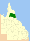
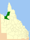
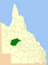
The Shire of Richmond is a local government area in north western Queensland, Australia.

<span class="mw-page-title-main">Shire of Douglas</span> Local government area in Queensland, Australia

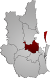
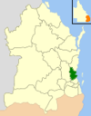
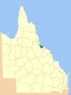
The Shire of Douglas is a local government area in Far North Queensland. It is located on the coast north of the city of Cairns. The shire, administered from the town of Mossman, covers an area of 2,428 square kilometres (937.5 sq mi), and existed as a local government entity from 1880 until 2008, when it was amalgamated with the City of Cairns to become the Cairns Region. Following a poll in 2013, the Shire of Douglas was re-established on 1 January 2014.

<span class="mw-page-title-main">Shire of Etheridge</span> Local government area in Queensland, Australia

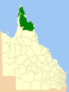
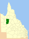
The Shire of Etheridge is a local government area in Far North Queensland, Australia in what is known as the Savannah Gulf region. Its economy is based on cattle grazing and mining.

<span class="mw-page-title-main">Shire of Croydon</span> Local government area in Queensland, Australia

The Shire of Croydon is a local government area in western Queensland, Australia. The shire, administered from the town of Croydon, covers an area of 29,498 square kilometres (11,389.2 sq mi). The council consists of a mayor plus four councillors, each of whom represents the entire Shire.

<span class="mw-page-title-main">Shire of Torres</span> Local government area in Queensland, Australia

The Shire of Torres is a local government area located in Far North Queensland, Australia, covering large sections of the Torres Strait Islands and the northern tip of Cape York Peninsula north of 11°S latitude. It holds two distinctions—it is the northernmost Local Government Area in Australia, and is the only one to abut an international border – it is at one point just 73 kilometres (45 mi) from Papua New Guinea. It is administered from Thursday Island.

<span class="mw-page-title-main">City of Moreton Bay</span> Local government area in Australia

The City of Moreton Bay, known until July 2023 as the Moreton Bay Region, is a local government area in the north of the Brisbane metropolitan city in South East Queensland, Australia. Established in 2008, it replaced three established local government areas, the City of Redcliffe and the Shires of Pine Rivers and Caboolture.

<span class="mw-page-title-main">South Burnett Region</span> Local government area in Queensland, Australia

The South Burnett Region is a local government area in the South Burnett district of Queensland, Australia.

<span class="mw-page-title-main">Maranoa Region</span> Local government area in Queensland, Australia

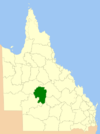
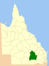
Maranoa Region is a local government area in South West Queensland, Australia. The town of Roma is the administrative headquarters of the region.

<span class="mw-page-title-main">Isaac Region</span> Local government area in Queensland, Australia

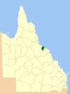
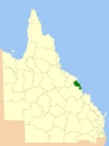
The Isaac Region is a local government area located in Central Queensland, Queensland, Australia created in March 2008 as a result of the report of the Local Government Reform Commission released in July 2007.

<span class="mw-page-title-main">Barcaldine Region</span> Local government area in Queensland, Australia

The Barcaldine Region is a local government area in Central West Queensland, Australia. Established in 2008, it was preceded by three previous local government areas which had existed for over a century.

<span class="mw-page-title-main">Central Highlands Region</span> Local government area in Queensland, Australia

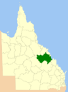
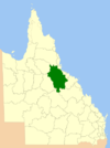
Central Highlands Region is a local government area in Queensland, Australia. In the 2021 census, the Central Highlands Region had a population of 27,836 people.

<span class="mw-page-title-main">Cassowary Coast Region</span> Local government area in Queensland, Australia

The Cassowary Coast Region is a local government area in the Far North Queensland region of Queensland, Australia, south of Cairns and centred on the towns of Innisfail, Cardwell and Tully. It was created in 2008 from a merger of the Shire of Cardwell and the Shire of Johnstone.

<span class="mw-page-title-main">Bundaberg Region</span> Local government area in Queensland, Australia

The Bundaberg Region is a local government area in the Wide Bay–Burnett region of Queensland, Australia, about 360 kilometres (220 mi) north of Brisbane, the state capital. It is centred on the city of Bundaberg, and also contains a significant rural area surrounding the city. It was created in 2008 from a merger of the City of Bundaberg with the Shires of Burnett, Isis and Kolan.

<span class="mw-page-title-main">Charters Towers Region</span> Local government area in Queensland, Australia

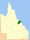
The Charters Towers Region is a local government area in North Queensland, Australia southwest of, and inland from the city of Townsville, based in Charters Towers. Established in 2008, it was preceded by two previous local government areas which dated back to the 1870s.

<span class="mw-page-title-main">Goondiwindi Region</span> Local government area in Queensland, Australia

The Goondiwindi Region is a local government area located in the Darling Downs region of Queensland, Australia along the state's border with New South Wales. Established in 2008, it was preceded by three previous local government areas which dated back to the 19th century.

<span class="mw-page-title-main">Gympie Region</span> Local government area in Queensland, Australia

The Gympie Region is a local government area in the Wide Bay–Burnett region of Queensland, Australia, about 170 kilometres (110 mi) north of Brisbane, the state capital. It is between the Sunshine Coast and Hervey Bay and centred on the town of Gympie. It was created in 2008 from a merger of the Shires of Cooloola and Kilkivan and part of the Shire of Tiaro.

<span class="mw-page-title-main">Scenic Rim Region</span> Local government area in Queensland, Australia

The Scenic Rim Region is a local government area (LGA) in the West Moreton region of South East Queensland, Australia, and is located approximately 80 kilometres due south of Brisbane. Established in 2008, it was preceded by several previous local government areas with histories extending back to the early 1900s and beyond. The main town of the region is Beaudesert.

<span class="mw-page-title-main">Cairns Region</span> Local government area of Queensland, Australia

The Cairns Region is a local government area in Far North Queensland, Queensland, Australia, centred on the regional city of Cairns. It was established in 2008 by the amalgamation of the City of Cairns and the Shires of Douglas and Mulgrave. However, following public protest and a referendum in 2013, on 1 January 2014, the Shire of Douglas was de-amalgamated from the Cairns Region and re-established as a separate local government authority.

<span class="mw-page-title-main">Northern Peninsula Area Region</span> Local government area in Queensland, Australia

The Northern Peninsula Area Region is a local government area in Far North Queensland, Australia, covering areas on the northwestern coast of Cape York Peninsula. It was created in March 2008 out of three Aboriginal Shires and two autonomous Island Councils during a period of statewide local government reform.

<span class="mw-page-title-main">Wujal Wujal Aboriginal Shire</span> Local government area in Queensland, Australia

The Wujal Wujal Aboriginal Shire is a local government area in Far North Queensland, Australia. It is managed as a Deed of Grant in Trust under the Local Government Act 2004.

References

  1. "3218.0 – Regional Population Growth, Australia, 2017-18: Population Estimates by Local Government Area (ASGS 2018), 2017 to 2018". Australian Bureau of Statistics. Australian Bureau of Statistics. 27 March 2019. Retrieved 25 October 2019. Estimated resident population, 30 June 2018.
  2. "Regional population, 2021-22 financial year | Australian Bureau of Statistics". www.abs.gov.au. 31 August 2023. Retrieved 31 October 2024.
  3. "Agency ID 11054, Gympie Regional Council". Queensland State Archives . Retrieved 9 September 2013.