Shire of Duaringa

Last updated

Shire of Duaringa
Queensland
Duaringa LGA Qld.png
Location within Queensland
Population6,744 (2006 census) [1]
 • Density0.37053/km2 (0.95967/sq mi)
Area18,201 km2 (7,027.4 sq mi)
Council seat Duaringa
Region Capricornia
Duaringa Logo.png
Website Shire of Duaringa
LGAs around Shire of Duaringa:
Broadsound Broadsound Livingstone
Emerald Shire of Duaringa Fitzroy
Bauhinia Taroom Banana

The Shire of Duaringa was a local government area in the Capricornia region of Queensland, Australia. Duaringa Shire covered an area of 18,201 square kilometres and had a population of 6,744 according to the 2006 census. [1] On 15 March 2008 the shires of Duaringa, Emerald, Bauhinia and Peak Downs were amalgamated to form the Central Highlands Region.

Contents

History

Map of Duaringa Division and adjacent local government areas, March 1902 Duaringa Division, March 1902.jpg
Map of Duaringa Division and adjacent local government areas, March 1902

Banana Division was created on 11 November 1879 as one of 74 divisions around Queensland under the Divisional Boards Act 1879. [2] On 20 April 1881 part of Banana Division was separated to create Duaringa Division. [3]

On 4 January 1884, there was an adjustment of boundaries between Bauhinia Division's subdivisions Nos. 2 and 3 and the Duaringa Division. [4] [5] Soon after, on 20 March 1884, there was a further adjustment of boundaries between Bauhinia Division's subdivisions Nos. 1 and 3 and Duaringa Division. [6] [7]

On 3 March 1892, part of subdivision 2 of the Broadsound Division was transferred to subdivision 3 of the Gogango Division, while another part of subdivision 2 of the Broadsound Division was transferred to the Duaringa Division. [8]

With the passage of the Local Authorities Act 1902, Banana Division became Shire on Banana on 31 March 1903.

On 15 March 2008 the Shires of Duaringa, Emerald, Bauhinia and Peak Downs were amalgamated to form the Central Highlands Region. [9]

Towns and localities

The Shire of Duaringa included the following settlements:

Towns:

Township:

Others

The Aboriginal Shire of Woorabinda is located in five separate locations inside the former Shire of Duaringa - three of them wholly surrounded by Duaringa, and two on the border with Fitzroy Shire.

Economy

Duaringa is a local centre for the region's farmers, who cultivate sorghum and wheat, and graze beef cattle. Mining is another major industry within the Shire, due to the vast coal deposits around Blackwater.

Chairmen

Related Research Articles

Shire of Livingstone Local government area in Queensland, Australia

The Shire of Livingstone is a local government area located in the Capricornia region of Central Queensland, Queensland, Australia, to the immediate north and east of the regional city of Rockhampton. The shire, administered from the coastal town of Yeppoon, covers an area of 11,758 square kilometres (4,539.8 sq mi), and existed as a local government entity from 1879 until 2008, when it amalgamated with several other councils to become the Rockhampton Region. The Shire was re-established on 1 January 2014 following a successful de-amalgamation referendum in 2013.

Shire of Peak Downs Local government area in Queensland, Australia

The Shire of Peak Downs was a local government area in the Central Highlands of Queensland, Australia, 320 km west of both Rockhampton and Mackay. On 15 March 2008 the shires of Duaringa, Emerald, Bauhinia and Peak Downs were amalgamated to form the Central Highlands Region.

Shire of Broadsound Local government area in Queensland, Australia

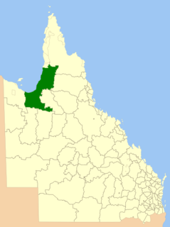
Shire of Broadsound was a local government area in the Capricornia region of Queensland, Australia. The Shire, administered from the town of St Lawrence, covered an area of 18,546.0 square kilometres (7,160.7 sq mi), and existed as a local government entity from 1879 until 2008, when it was amalgamated with the Shires of Belyando and Nebo to form the Isaac Region.

Shire of Emerald Local government area in Queensland, Australia

The Shire of Emerald is a former local government area in the Central Highlands region of Queensland, Australia. On 15 March 2008 the shires of Duaringa, Emerald, Bauhinia and Peak Downs were amalgamated to form the Central Highlands Region. Its administrative centre is based around Emerald.

Shire of Bauhinia Local government area in Queensland, Australia

The Shire of Bauhinia was a local government area in Central Queensland, Queensland, Australia. The Shire, administered from the town of Springsure, covered an area of 23,649.6 square kilometres (9,131.2 sq mi), and existed as a local government entity from 1879 until 2008, when it was amalgamated with the Shires of Duaringa, Emerald and Peak Downs to form the Central Highlands Region.

Shire of Cloncurry Local government area in Queensland, Australia

The Shire of Cloncurry is a local government area in North West Queensland, Australia. It covers an area of 47,971 square kilometres (18,521.7 sq mi), and has existed as a local government entity since 1884. The major town and administrative centre of the shire is Cloncurry.

Shire of Belyando Local government area in Queensland, Australia

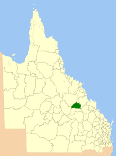
The Shire of Belyando was a local government area in Central Queensland, Australia. The Shire, administered from the town of Clermont, covered an area of 30,281.3 square kilometres (11,691.7 sq mi), and existed as a local government entity from 1879 until 2008, when it was amalgamated with the Shires of Broadsound and Nebo to form the Isaac Region.

Shire of Nebo Local government area in Queensland, Australia

The Shire of Nebo was a local government area in Central Queensland, Queensland, Australia, about 80 kilometres (50 mi) south-west of the regional city of Mackay. The Shire, administered from the town of Nebo, covered an area of 10,034.6 square kilometres (3,874.4 sq mi), and existed as a local government entity from 1883 until 2008, when it was amalgamated with the Shires of Belyando and Broadsound to form the Isaac Region.

Shire of Carpentaria Local government area in Queensland, Australia

The Shire of Carpentaria is a local government area in Far North Queensland, Australia on the Gulf of Carpentaria, for which it is named.

Shire of Boonah Local government area in Queensland, Australia

The Shire of Boonah was a local government area in South East Queensland, Australia, about 80 kilometres (50 mi) southwest of Brisbane. The shire covered an area of 1,921.6 square kilometres (741.9 sq mi), and existed from 1880 until its merger with parts of the Shire of Beaudesert and City of Ipswich to form the Scenic Rim Region on 15 March 2008.

Shire of Atherton Local government area in Queensland, Australia

The Shire of Atherton was a local government area of Queensland. It was located on the Atherton Tableland, a plateau forming part of the Great Dividing Range west of the city of Cairns. The shire, administered from the town of Atherton, covered an area of 623.1 square kilometres (240.6 sq mi), and existed as a local government entity from 1881 until 2008, when it amalgamated with several other councils in the Tableland area to become the Tablelands Region.

Shire of Hinchinbrook Local government area in Queensland, Australia

The Shire of Hinchinbrook is a local government area in North Queensland, Queensland, Australia. The shire, administered from the town of Ingham, covers an area of 2,807 square kilometres (1,083.8 sq mi), and has existed since its creation on 11 November 1879 as one of 74 divisions around Queensland under the Divisional Boards Act 1879.

Beaudesert Shire Local government area in Queensland, Australia

The Shire of Beaudesert was a local government area located in South East Queensland, Australia, stretching from the New South Wales border, along the Gold Coast hinterland to the urban fringes of the cities of Brisbane and Ipswich. The Shire covered an area of 2,854.3 square kilometres (1,102.1 sq mi), and existed from 1879 until its abolition on 15 March 2008, following which it was split between Logan City and the new Scenic Rim Region.

Shire of Rosenthal Local government area in Queensland, Australia

The Shire of Rosenthal was a local government area south and west of the regional centre of Warwick in the Darling Downs region of Queensland. The shire, administered from Rosenthal Heights, a Warwick suburb, covered an area of 1,984.1 square kilometres (766.1 sq mi), and existed as a local government entity from 1886 until 1994, when it was dissolved and amalgamated with City of Warwick, Shire of Allora and Shire of Glengallan to form the Shire of Warwick.

Shire of Belmont

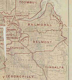
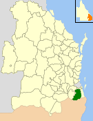
The Shire of Belmont is a former local government area of Queensland, Australia, located in eastern Brisbane including the current suburb of Belmont.

Shire of Coomera

The Shire of Coomera was a local government area in South East Queensland, Australia. The shire, administered from Coomera, existed as a local government entity from 1879 until 1949.

Shire of Nerang

The Shire of Nerang was a local government area in South East Queensland, Australia. The shire existed as a local government entity from 1879 until 1949.

Town of Southport

The Town of Southport was a local government area in South East Queensland, Australia.

Shire of Mutdapilly

The Shire of Mutdapilly is a former local government area in the south-east of Queensland, Australia. The name comes from the Mutdapilly locality, but the locality was never the administrative centre of the shire.

References

  1. 1 2 Australian Bureau of Statistics (25 October 2007). "Duaringa (S) (Local Government Area)". 2006 Census QuickStats. Retrieved 7 January 2017.
  2. "Proclamation [Nogoa Division]". Queensland Government Gazette . 11 November 1879. p. 25:1004.
  3. "Proclamation [Banana & Duaringa Divisions]". Queensland Government Gazette . 23 April 1881. p. 28:1068-1069.
  4. "Proclamation [Bauhinia Division amended]". Queensland Government Gazette . 5 January 1884. p. 34:19.
  5. "Proclamation [Duaringa Division amended]". Queensland Government Gazette . 5 January 1884. p. 34:20-21.
  6. "Proclamation [Bauhinia Division amended]". Queensland Government Gazette . 22 March 1884. p. 34:893.
  7. "Proclamation [Duaringa Division amended]". Queensland Government Gazette . 22 March 1884. p. 34:894.
  8. "Order in Council [Broadsound, Gogango and Duaringa Divisions]". Queensland Government Gazette . 5 March 1892. p. 55:920.
  9. "Agency ID 11030, Central Highlands Regional Council". Queensland State Archives . Retrieved 8 September 2013.
  10. 1 2 3 4 5 6 7 8 9 10 11 12 13 14 15 16 17 Turner, Denise | Duaringa Shire : 100 years of local government, 1881-1981 | published in 1981 | published by Duaringa Shire Council | ISBN   978-0-9593293-0-8
  11. "Duaringa Divisional Board". The Daily Northern Argus . 1 (2319). Queensland, Australia. 26 September 1892. p. 5. Retrieved 2 November 2016 via National Library of Australia.
  12. "DUARINGA DIVISIONAL BOARD". Morning Bulletin . XLVIII (9689). Queensland, Australia. 13 May 1895. p. 6. Retrieved 2 November 2016 via National Library of Australia.
  13. "QUEENSLAND NEWS". Morning Bulletin . LXI (10, 520). Queensland, Australia. 4 April 1898. p. 5. Retrieved 2 November 2016 via National Library of Australia.
  14. Pugh, Theophilus Parsons (1927). Pugh's Almanac for 1927 . Retrieved 13 June 2014.
  15. "COUNTRY WOMEN". Morning Bulletin (21, 141). Queensland, Australia. 27 April 1934. p. 14. Retrieved 2 November 2016 via National Library of Australia.
  16. "PARK, William Kerrod". It's An Honour. Australian Government. Archived from the original on 6 January 2019. Retrieved 6 January 2019.
  17. Former mayor denies agreement for Duaringa Shire to build 'Australian-themed playground' in Japan, Matthew Killoran, The Sunday Mail, 24 May 2015. Retrieved 18 December 2016.
  18. Duaringa mayor sworn in today, ABC News, 7 April 2004. Retrieved 18 December 2016.

Coordinates: 23°43′03.64″S149°40′11″E / 23.7176778°S 149.66972°E / -23.7176778; 149.66972