
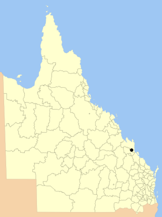
The Town of Croydon was a local government area for the governance of Croydon, Queensland, Australia. It existed from 1892 to 1908.
The Town of Croydon was a local government area for the governance of Croydon, Queensland, Australia. It existed from 1892 to 1908.
The Borough of Croydon was established in 1868 as a municipal council for Croydon. [1]
With the passing of the Local Authorities Act 1902, on 31 March 1903 the Borough of Croydon became the Town of Croydon.
On 19 December 1908, the Town of Croydon was absorbed into the surrounding Shire of Croydon. [2]

The Croydon Town Hall was believed to be built about 1892 as a town hall. It is located on the northern side of Samwell Street, right to the right of the intersection with Temple Street. In the 1960s the town hall became the headquarters of the Croydon Shire Council until 1991 when the shire built new offices of the other side of Samwell Street. The building was listed on the Queensland Heritage Register on 11 June 1996. [3]
The mayors of the Town of Croydon were: [4]

The Town of Windsor is a former local government area of Queensland, Australia, located in northern Brisbane.

Normanton is an outback town and coastal locality in the Shire of Carpentaria, Queensland, Australia. At the 2021 census, the locality of Normanton had a population of 1,391 people, and the town of Normanton had a population of 1,326 people.

Croydon is an outback town and locality within the Shire of Croydon in Queensland, Australia. It is a terminus for the Normanton to Croydon railway line, which operates the Gulflander tourist train. In the 2021 census, the locality of Croydon had a population of 215 people.

The Shire of Pine Rivers was a local government area about 20 kilometres (12 mi) north of Brisbane in the Moreton Bay region of South East Queensland, Australia. The shire covered an area of 771 square kilometres (297.7 sq mi), and existed as a local government entity from 1888 until 2008, when it amalgamated with councils further north and east to form the Moreton Bay Region, renamed in July 2023 as the City of Moreton Bay.

The Shire of Barcaldine was a local government area located in central Queensland and headquartered in the town of Barcaldine. It covered an area of 8,448.4 square kilometres (3,261.9 sq mi), and existed as a local government entity from 1892 until 2008, when it amalgamated with the Shires of Aramac and Jericho to form the Barcaldine Region.

The Shire of Dalrymple was a local government area located in North Queensland, Australia, and surrounded but did not include the town of Charters Towers, at which its council and administrative centre was based. It covered an area of 68,324.5 square kilometres (26,380.2 sq mi), and existed as a local government entity from 1879 until 2008, when it amalgamated with the separate City of Charters Towers to form the Charters Towers Region.

The Shire of Croydon is a local government area in western Queensland, Australia. The shire, administered from the town of Croydon, covers an area of 29,498 square kilometres (11,389.2 sq mi). The council consists of a mayor plus four councillors, each of whom represents the entire Shire.

The Shire of Cardwell was a local government area of Queensland. It was located on the Coral Sea coast about halfway between the cities of Cairns and Townsville. The shire, administered from the town of Tully, covered an area of 3,062.2 square kilometres (1,182.3 sq mi), and existed as a local government entity from 1884 until 2008, when it amalgamated with the Shire of Johnstone to form the Cassowary Coast Region.
The City of Rockhampton was a local government area in the Central Queensland region of Queensland, Australia, encompassing most of the suburban area of the regional city of Rockhampton. The city covered an area of 188.7 square kilometres (72.9 sq mi), and has existed as a local government entity in various forms from 1860 until 2008, when it amalgamated with several other councils in the surrounding area to become the Rockhampton Region.

The City of Mackay was a local government area located in the Central Queensland region of Queensland, Australia, encompassing the regional city of Mackay and the surrounding region. The City was created as a municipal borough in 1869, and prior to amalgamation with the Shire of Pioneer in 1994, the City was limited to the central suburbs on the south shore of the Pioneer River. From 1994 until 2008, the City covered an area of 2,897.5 square kilometres (1,118.7 sq mi). In 2008, it amalgamated with the Shires of Mirani and Sarina to become the Mackay Regional Council.
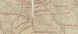
The Shire of Stephens was a local government area in the inner southern suburbs of Brisbane, Queensland, Australia. The shire, administered from Annerley, covered an area of 9 square miles (23 km2), and existed as a local government entity from 1886 until 1925, when it was amalgamated into the City of Brisbane under the City of Brisbane Act 1924.

The Shire of Toombul was a local government area of Queensland, Australia, located in northern Brisbane from 1883 to 1925.

The City of Gympie is a former local government area in the south-east of Queensland, Australia, responsible for governing Gympie.
The Town of Cooktown is the former local government area for Cooktown in Far North Queensland, Australia. It existed from 1876 to 1932.
The Shire of Widgee is a former local government area in the Wide Bay–Burnett area of Queensland, Australia. It was located in the rural areas around the town of Gympie but did not include the town itself, which was always in a separate local government area. The administrative offices of the Shire of Widgee were located in Gympie.

Cardwell Divisional Board Hall is a heritage-listed former town hall at 51 Victoria Street, Cardwell, Cassowary Coast Region, Queensland, Australia. It is also known as the Cardwell Shire Chambers, Cardwell Shire Hall, JC Hubinger Memorial Museum, JC Hubinger Museum, and JC Hubinger Memorial Hall. The hall and its World War I honour roll were added to the Queensland Heritage Register on 21 March 2013.

Croydon Court House is a heritage-listed former courthouse at Samwell Street, Croydon, Shire of Croydon, Queensland, Australia. It was designed by Colonial Architect's Office and built in 1887. It was added to the Queensland Heritage Register on 21 October 1992.

Croydon Police Station is a heritage-listed former police station at Samwell Street, Croydon, Shire of Croydon, Queensland, Australia. It was built in 1899. It is also known as Former Police Station and Residence. It was added to the Queensland Heritage Register on 23 July 1999.
Croydon Shire Hall is a heritage-listed town hall at Samwell Street, Croydon, Shire of Croydon, Queensland, Australia. It was built c. 1892. It is also known as Croydon Shire Office and Croydon Town Hall. It was added to the Queensland Heritage Register on 11 June 1996.

Croydon Hospital Ward is a heritage-listed former hospital at Sircom Street, Croydon, Shire of Croydon, Queensland, Australia. It was built in 1894. It is also known as Croydon State Emergency Services Building. It was added to the Queensland Heritage Register on 21 October 1992.