
Surat is a rural town and locality in the Maranoa Region, Queensland, Australia. In the 2016 census, the locality had a population of 407 people.

The Shire of Livingstone is a local government area located in the Capricornia region of Central Queensland, Queensland, Australia, to the immediate north and east of the regional city of Rockhampton. The shire, administered from the coastal town of Yeppoon, covers an area of 11,758 square kilometres (4,539.8 sq mi), and existed as a local government entity from 1879 until 2008, when it amalgamated with several other councils to become the Rockhampton Region. The Shire was re-established on 1 January 2014 following a successful de-amalgamation referendum in 2013.

The Shire of Perry was a local government area in the northern catchment of the Burnett River, Queensland, Australia. The Shire covered an area of 2,357.7 square kilometres (910.3 sq mi), and existed as a local government area from 1880 until 2008, when it amalgamated with several other shires to form the North Burnett Region.

The Shire of Aramac was a local government area located in central Queensland about 1,100 kilometres (684 mi) north west of the state capital, Brisbane, between the towns of Barcaldine and Winton. It covered an area of 23,364.1 square kilometres (9,020.9 sq mi), and existed as a local government entity from 1879 until 2008, when it amalgamated with the Shires of Barcaldine and Jericho to form the Barcaldine Region.

The Shire of Calliope was a local government area in the Capricornia region of Queensland, Australia. It was centred on the town of Calliope.

The Shire of Miriam Vale was a local government area near Gladstone in Queensland, Australia. The administrative centre was the town of Miriam Vale.

Shire of Broadsound was a local government area in the Capricornia region of Queensland, Australia. The Shire, administered from the town of St Lawrence, covered an area of 18,546.0 square kilometres (7,160.7 sq mi), and existed as a local government entity from 1879 until 2008, when it was amalgamated with the Shires of Belyando and Nebo to form the Isaac Region.

The Shire of Taroom was a local government area in the Darling Downs region of Queensland, Australia, along the Leichhardt Highway to the north of Miles. The shire covered an area of 18,644.5 square kilometres (7,198.7 sq mi), and existed as a local government area from 1879 until 2008, when it was dissolved and split between the new Western Downs Region and the Shire of Banana.

The Shire of Murilla was a local government area located in the Darling Downs region of Queensland, Australia. The shire, administered from the town of Miles, covered an area of 6,075.8 square kilometres (2,345.9 sq mi), and existed as a local government entity from 1879 until 2008, when it amalgamated with the Town of Dalby and the Shires of Chinchilla, Tara and Wambo and the southern part of Taroom to form the Western Downs Region.
The Shire of Wambo was a local government area in the Darling Downs region of Queensland, Australia. The shire completely surrounded but did not include the town of Dalby — which had its own municipal government. It covered an area of 5,709.7 square kilometres (2,204.5 sq mi), and existed as a local government entity from 1879 until 2008, when it amalgamated with the Town of Dalby and the Shires of Chinchilla, Murilla and Tara and the southern part of Taroom to form the Western Downs Region.

The Shire of Bendemere was a local government area in the Maranoa region of Queensland, Australia, and existed from 1911 until 2008 when it amalgamated into Maranoa Region. The Shire, administered from the town of Yuleba, covered an area of 3,926.8 square kilometres (1,516.1 sq mi), and existed as a local government entity from 1911 until 2008, when it was amalgamated with the Town of Roma and the Shires of Booringa, Bungil and Warroo to form the Maranoa Region.
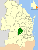
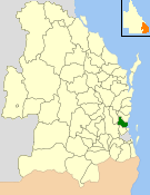
The Shire of Bungil was a local government area in the Maranoa region of Queensland, Australia. It existed from 1880 to 2008.

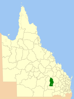
The Shire of Booringa was a local government area in the Maranoa region of Queensland, Australia. The largest town and home of the shire administration was Mitchell. It existed from 1879 to 2008. The shire is now part of the Maranoa Region.

The Shire of Barcaldine was a local government area located in central Queensland and headquartered in the town of Barcaldine. It covered an area of 8,448.4 square kilometres (3,261.9 sq mi), and existed as a local government entity from 1892 until 2008, when it amalgamated with the Shires of Aramac and Jericho to form the Barcaldine Region.
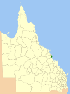
The Shire of Sarina was a local government area located in the Central Queensland region of Queensland, Australia. The shire, administered from the town of Sarina, covered an area of 1,444.3 square kilometres (557.6 sq mi), and existed as a local government entity from 1912 until 2008, when it amalgamated with the City of Mackay and the Shire of Mirani to form the Mackay Region.

The Shire of Boonah was a local government area in South East Queensland, Australia, about 80 kilometres (50 mi) southwest of Brisbane. The shire covered an area of 1,921.6 square kilometres (741.9 sq mi), and existed from 1880 until its merger with parts of the Shire of Beaudesert and City of Ipswich to form the Scenic Rim Region on 15 March 2008.

The Town of Roma was a local government area in the western Downs region of Queensland, Australia. The Town of Roma covered the urban area of Roma and was completely surrounded by the neighbouring Shire of Bungil. Today it is part of the Maranoa Region. At the 2011 census the Town had a population of 6,906
The Shire of Caboolture was a local government area located in the Australian state of Queensland on the northern urban fringe of the capital, Brisbane, and south of the Sunshine Coast. The Shire covered an area of 1,224.4 square kilometres (472.7 sq mi), of which approximately one-quarter was urban, and existed as a local government entity from 1879 until 2008, when it amalgamated with the City of Redcliffe and Shire of Pine Rivers to form the Moreton Bay Region.

Maranoa Region is a local government area in South West Queensland, Australia. The town of Roma is the administrative headquarters of the region.

The Shire of Pioneer was a local government area surrounding the city of Mackay and including all but its innermost suburbs. The shire, administered from Mackay itself, covered an area of 2,820.1 square kilometres (1,088.8 sq mi), and existed as a local government entity from 1879 until 1994, when it was dissolved and amalgamated with City of Mackay.


