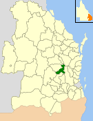
The Shire of Enoggera is a former local government area of Queensland, Australia, located in north-western Brisbane.
The Shire of Enoggera is a former local government area of Queensland, Australia, located in north-western Brisbane.
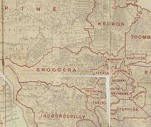
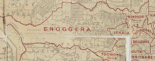
Ithaca Division was one of the original divisions created on 11 November 1879 under the Divisional Boards Act 1879. It comprised 3 subdivisions. By 1886, the residents of subdivision 1 were petitioning to separate and become the Shire of Windsor, [1] resulting in the establishment of the Shire of Windsor on 11 February 1887. [2] Meanwhile, the residents of subdivision 2 were petitioning to separate and become the Shire of Ithaca, [3] resulting in the creation of the Shire of Ithaca on 18 August 1887. [4]
The now much-depleted Ithaca Division then requested to be renamed the Enoggera Division [5] and this occurred on 28 March 1888. [6]
The Local Authorities Act 1902 replaced divisions with shires and towns. As a result, on 31 March 1903, the Enoggera Division became the Shire of Enoggera. [6] [7]
On 1 October 1925, the shire was amalgamated into the City of Brisbane. [7]

The chairmen of the division and shire were: [8]

The Town of Windsor is a former local government area of Queensland, Australia, located in northern Brisbane.

The Gap is a north-western suburb in the City of Brisbane, Queensland, Australia. In the 2021 census, The Gap had a population of 17,318 people.

Ashgrove is a suburb in the City of Brisbane, Queensland, Australia. In the 2021 census, Ashgrove had a population of 13,716 people.

Red Hill is an inner northern suburb in the City of Brisbane, Queensland, Australia. In the 2016 census, Red Hill had a population of 5,560 people.

Enoggera is a north-western suburb in the City of Brisbane, Queensland, Australia. It is home to the Gallipoli Barracks.
The Shire of Nanango was a local government area located in the South Burnett region of Queensland, Australia, about 100 kilometres (62 mi) northwest of the capital, Brisbane. The Shire covered an area of 1,738.4 square kilometres (671.2 sq mi), and existed as a local government entity from 1879 until 2008, when it amalgamated with several other councils in the South Burnett area to become the South Burnett Regional Council.

The Shire of Kilkivan was a local government area about 180 kilometres (112 mi) north-northwest of Brisbane, the state capital of Queensland, Australia. The shire covered an area of 3,263.4 square kilometres (1,260.0 sq mi), and existed from 1886 until its merger with several other local government areas to form the Gympie Region on 15 March 2008.

The Shire of Tiaro was a local government area in the Wide Bay–Burnett region of Queensland, Australia, between the regional cities of Gympie and Hervey Bay about 220 kilometres (137 mi) north of the state capital, Brisbane. The shire covered an area of 2,185.3 square kilometres (843.7 sq mi), and existed as a local government area from 1879 until 2008, when it was dissolved and split between two new local government areas, the Gympie Region and the Fraser Coast Region.

The Shire of Boonah was a local government area in South East Queensland, Australia, about 80 kilometres (50 mi) southwest of Brisbane. The shire covered an area of 1,921.6 square kilometres (741.9 sq mi), and existed from 1880 until its merger with parts of the Shire of Beaudesert and City of Ipswich to form the Scenic Rim Region on 15 March 2008.
The Town of Ithaca is a former local government area of Queensland, Australia, located in inner western Brisbane.
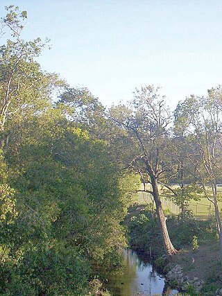
Enoggera Creek is a creek which flows through the City of Brisbane in South-East Queensland, Australia.
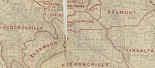
The Shire of Stephens was a local government area in the inner southern suburbs of Brisbane, Queensland, Australia. The shire, administered from Annerley, covered an area of 9 square miles (23 km2), and existed as a local government entity from 1886 until 1925, when it was amalgamated into the City of Brisbane under the City of Brisbane Act 1924.
The Ithaca Division is a former local government area of Queensland, Australia, located in north-western Brisbane.
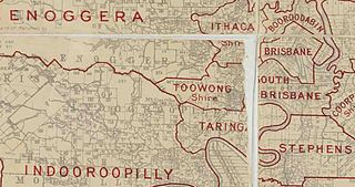
The Town of Toowong is a former local government area of Queensland, Australia, located in western Brisbane in the area around the current suburb of Toowong.

The Shire of Moggill is a former local government area of Queensland, Australia, located in western Brisbane.

The Shire of Taringa is a former local government area of Queensland, Australia, located in western Brisbane. Its administrative centre was Taringa. It existed from 1890 to 1925.

The Shire of Nerang was a local government area in South East Queensland, Australia. The shire existed as a local government entity from 1879 until 1949.

The Shire of Mutdapilly is a former local government area in the south-east of Queensland, Australia. The name comes from the Mutdapilly locality, but the locality was never the administrative centre of the shire.

The Ithaca Town Council Chambers is a heritage-listed former town hall of the former local government area of the Town of Ithaca, and now a community centre in Paddington, City of Brisbane, Queensland, Australia. Located at 99 Enoggera Terrace, Red Hill, it was designed by Atkinson and McLay and built in 1910 by Charles Thomas Hall and Francis Joseph Mayer. It is also known as Ithaca Library and Red Hill Kindergarten. It was added to the Queensland Heritage Register on 24 March 2000.
The Shire of Widgee is a former local government area in the Wide Bay–Burnett area of Queensland, Australia. It was located in the rural areas around the town of Gympie but did not include the town itself, which was always in a separate local government area. The administrative offices of the Shire of Widgee were located in Gympie.