Towns and localities

The Shire of Albert included the following settlements:
Gold Coast suburbs: | Northern Albert region: | Western Albert region:
|
1 - not to be confused with Willowvale of the Southern Downs Region
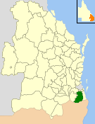
| Shire of Albert Queensland | |||||||||||||||
|---|---|---|---|---|---|---|---|---|---|---|---|---|---|---|---|
| Population | 143,697 (1991 census) [1] | ||||||||||||||
| • Density | 117.419/km2 (304.113/sq mi) | ||||||||||||||
| Established | 1948 | ||||||||||||||
| Area | 1,223.8 km2 (472.5 sq mi) | ||||||||||||||
| Council seat | Nerang | ||||||||||||||
| Region | South East Queensland | ||||||||||||||
| |||||||||||||||
The Shire of Albert was a local government area in Queensland, located south of the capital, Brisbane, and taking in areas to the north and west of the Gold Coast. It was named after the Prince Consort of the United Kingdom, and husband of Queen Victoria, Prince Albert. When created in 1948, it was primarily a rural area, but its growth started in earnest in the late 1960s with the development of Logan on Brisbane's southern frontier. After the separate creation of Logan as a shire (later City) in 1978, Albert lost most of its population and became more centred upon the Gold Coast, which experienced a massive period of growth from then until the Shire's amalgamation with the City of Gold Coast in 1995.
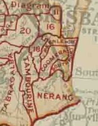
By the late 1870s, the Government of Queensland had become preoccupied with the idea of getting local residents to pay through rates for local services, which had become a massive cost to the colony and were undermaintained in many areas. The McIlwraith government initiated the Divisional Boards Act 1879 which created a system of elected divisional boards covering most of Queensland. It was assented by the Governor on 2 October 1879, and on 11 November 1879, the Governor gazetted a list of 74 divisions which would come into existence. Four of these—Nerang, Coomera, Beenleigh and Waterford—were in the Gold Coast region. Town dwellers had different needs to the rural landholders so Southport ratepayers lobbied the Queensland Government to create a separate Divisional Board so that rates monies raised by Southport landholders could be spent on town improvements. This resulted in the Southport Divisional Board on 14 July 1883.
On 31 March 1903, following the enactment of the Local Authorities Act 1902, the divisions became shires. On 12 June 1914, the Coolangatta was created from part of the Shire of Nerang, and on 12 April 1918, Southport became a Town.
On 9 December 1948, as part of a major reorganisation of local government in South East Queensland, an Order in Council replacing ten former local government areas between the City of Brisbane and the New South Wales border with only four. [2] [3] The former ten were:
The four resulting local government areas were:
The Order came into effect on 10 June 1949, when the first elections were held.
The northern part of the Shire expanded rapidly from the late 1960s onwards with the development of the Logan area, which had become a southeastern suburban growth corridor for Brisbane. A report produced in 1970 was the Albert Shire's first attempt at town planning. [5] The first approved plan wasn't released until 1973. [5] On 8 June 1978, the Shire of Logan was separately incorporated, and Albert lost 110.0 km2 (42.5 sq mi) of its area and 54,650 people in the change—almost three-quarters of its population. The effect of this change was to transform Albert into a purely Gold Coast-area council. With the astronomic growth levels experienced by the Gold Coast area from the late 1970s onwards, the new Albert grew from 18,753 at the 1976 census to 143,697 in 1991.
On 19 March 1992, the Electoral and Administrative Review Commission, created two years earlier, produced its report External Boundaries of Local Authorities, and recommended a number of changes to local government boundaries and the amalgamation of some local governments. [6] Although their recommendations only included boundary adjustments between City of Gold Coast and Albert Shire, the outcome following much public debate was a decision by the Queensland Government to absorb Albert Shire into Gold Coast City. The Local Government (Albert, Beaudesert and Gold Coast) Regulation 1994 was gazetted on 16 December 1994, resulting in the amalgamation of the Shire of Albert into Gold Coast City at the 1995 local government elections.
The Shire of Albert included the following settlements:
Gold Coast suburbs: | Northern Albert region: | Western Albert region:
|
1 - not to be confused with Willowvale of the Southern Downs Region
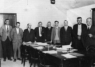
The following served as chairmen of the Shire of Albert: [7]
| Chairman | Term |
|---|---|
| Eric Gaven | 1949–1950 |
| Frank Oxenford | 1950–1952 |
| Alex Clark | 1952–1958 |
| Russ Hinze | 1958–1967 |
| Hugh Dunstan Muntz | 1967–1982 |
| Bill Laver | 1982–1994 |
| Ray Stevens | 1994–1995 |
In 1993, the Local Government Act Number 70 was introduced; it included that all heads of local government councils should be known as mayors and all other elected representatives were to be known as councillors. [8]
The population of the Albert region is only offered from the 1947 census onwards. The 1949 Queensland Year Book (p. 42) notes the following populations.
| Local Authority | Area (sq.mi.) | 1933 | 1947 |
|---|---|---|---|
| Beenleigh | 100 | 2,322 | 2,421 |
| Coomera | 118 | 1,152 | 1,114 |
| Nerang | 245 | 3,730 | 4,029 |
| Waterford | 135 | 1,052 | 1,004 |
| Total | 598 | 8,256 | 8,568 |
The 1950 Year Book, which uses the new boundaries, gives an area of 511 sq mi (1,323 km2) and a population of 7,261 (a difference of 1,307 people) for the Shire of Albert.
| Year | Population | Annual growth (%) |
|---|---|---|
| 1947 | 7,261 | N/A |
| 1954 | 8,714 | 2.64 |
| 1961 | 10,669 | 2.93 |
| 1966 | 13,782 | 5.25 |
| 1971 | 29,360 | 16.33 |
| 1976 | 72,062 | 19.67 |
Following the 1976 census, most of Albert's population were transferred to the new Logan local government area.
| Year | Population | Annual growth (%) |
|---|---|---|
| 1976 | 18,753 | N/A |
| 1981 | 54,870 | 23.95 |
| 1986 | 92,766 | 11.07 |
| 1991 | 143,697 | 9.15 |

The Logan River is a perennial river located in the Scenic Rim, Logan and Gold Coast local government areas of the South East region of Queensland, Australia. The 184-kilometre (114 mi)-long river is one of the dominant waterways in South East Queensland that drains the southern ranges of the Scenic Rim and empties into Moreton Bay after navigating the City of Logan, a major suburban centre located south of Brisbane. The catchment is dominated by urban and agricultural land use. Near the river mouth are mangrove forests and a number of aquaculture farms.

Logan City is a local government area situated within the south of the Brisbane metropolitan area in South East Queensland, Australia. Situated between the City of Brisbane to the north and the City of Gold Coast to the south, the City also borders the Scenic Rim Region, the City of Ipswich, and Redland City LGAs. Logan City is divided into 70 suburbs and 12 divisions; a councillor is elected to each of the latter. The area had a population of 326,615 in June 2018.
Albert was a Legislative Assembly electorate in the state of Queensland which existed from 1887 to 1949 and 1959 to 2017.

The Albert River is a perennial river located in the South East region of Queensland, Australia. Its catchment lies within the Gold Coast and Scenic Rim Region local government areas and covers an area of 782 square kilometres (302 sq mi). The river provides potable water for the town of Beaudesert.

The City of Gold Coast is the local government area spanning the Gold Coast, Queensland, Australia and surrounding areas. With a population of 606,774 it is the second most populous local government area in Australia. Its council maintains a staff of over 2,500. It was established in 1948, but has existed in its present form since 2008. The LGA is on the New South Wales border, next to Tweed Shire which is a New South Wales shire.
The South Coast railway line was a railway from Brisbane, the capital city of Queensland, Australia. The route via the South Coast to Tweed Heads on the border of Queensland and New South Wales. The line operated from 1889 to 1964. The Gold Coast railway line re-opened in 1996 along a modified alignment in the north and a new route south but does not extend as far south yet as the South Coast line.
The Shire of Beaudesert was a local government area located in South East Queensland, Australia, stretching from the New South Wales border, along the Gold Coast hinterland to the urban fringes of the cities of Brisbane and Ipswich. The Shire covered an area of 2,854.3 square kilometres (1,102.1 sq mi), and existed from 1879 until its abolition on 15 March 2008, following which it was split between Logan City and the new Scenic Rim Region.

The Scenic Rim Region is a local government area in West Moreton region of South East Queensland, Australia. Established in 2008, it was preceded by several previous local government areas with histories extending back to the early 1900s and beyond. The main town of the region is Beaudesert.
The Shire of Tingalpa was a local government area in the south-eastern suburbs of Brisbane, Queensland, Australia. The shire, administered from Mount Cotton, covered an area of 120 square miles (311 km2), and existed as a local government entity from 1879 until 1949.
The Mayor of the City of the Gold Coast is presiding officer and public face of the Gold Coast City Council, the local government body of the Gold Coast, Queensland. The current Mayor is Tom Tate.
The Shire of Beenleigh is a former local government area in the south-east of Queensland, Australia, centred on the town of Beenleigh. It existed from 1879 to 1949.

The Shire of Cleveland is a former local government area in the south-east of Queensland, Australia, centred on the town of Cleveland beside Moreton Bay.
The Shire of Waterford is a former local government area in the south-east of Queensland, Australia, centred on the town of Waterford. It existed between 1879 and 1948.

The Shire of Coomera was a local government area in South East Queensland, Australia. The shire, administered from Coomera, existed as a local government entity from 1879 until 1949.

The Shire of Nerang was a local government area in South East Queensland, Australia. The shire existed as a local government entity from 1879 until 1949.
The Shire of Tamborine was a local government area in South East Queensland, Australia, centred on the village of Tamborine. It existed from 1890 to 1949.

The Town of Southport was a local government area in South East Queensland, Australia.
The Town of Coolangatta was a local government area in South East Queensland, Australia, centred on Coolangatta. It existed from 1914 to 1949.
The Town of South Coast was a local government area in South East Queensland, Australia.

Tamborine is a town in the Scenic Rim Region and a locality split between the Scenic Rim Region and the City of Logan in Queensland, Australia. In the 2016 census the locality of Tamborine had a population of 3,950 people.
Coordinates: 27°59′56.32″S153°20′19.77″E / 27.9989778°S 153.3388250°E