
Coolangatta is a coastal suburb in the City of Gold Coast, Queensland, Australia. It is the Gold Coast's southernmost suburb and it borders New South Wales. In the 2021 census, Coolangatta had a population of 6,491 people.

Burleigh Heads is a suburb in the City of Gold Coast, Queensland, Australia. In the 2021 census, Burleigh Heads had a population of 10,572 people.

Currumbin is a coastal suburb in the City of Gold Coast, Queensland, Australia. In the 2021 census, Currumbin had a population of 3,278 people.

Mudgeeraba is a town and suburb in the City of Gold Coast, Queensland, Australia. In the 2021 census, the suburb of Mudgeeraba had a population of 14,578 people. Mudgeeraba's essential character remains one of a nineteenth-century village.

Palm Beach is a coastal suburb in the City of Gold Coast, Queensland, Australia. In the 2021 census, Palm Beach had a population of 16,349 people.

Ashmore is a suburb of the City of Gold Coast, Queensland, Australia. In the 2021 census, Ashmore had a population of 12,415 people.

Molendinar is a mixed-use suburb in the City of Gold Coast, Queensland, Australia. In the 2021 census, Molendinar had a population of 6,450 people.

Elanora is a suburb of the City of Gold Coast in Queensland, Australia. In the 2021 census, Elanora had a population of 12,539 people.

Arundel is a suburb in the City of Gold Coast, Queensland, Australia. In the 2021 census, Arundel had a population of 11,171 people.

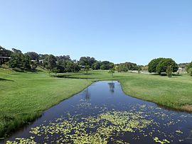
Tallebudgera Creek is a creek in South East Queensland, Australia. Its catchment lies within the Gold Coast local government area and covers an area of 98 square kilometres (38 sq mi). The river is approximately 25 kilometres (16 mi) in length and is known for good fishing.

Clagiraba is a rural locality in the City of Gold Coast, Queensland, Australia. In the 2021 census, Clagiraba had a population of 651 people.

Springbrook is a rural town and locality in the City of Gold Coast, Queensland, Australia. The locality borders New South Wales.
Meridan Plains is a locality on the north-western edge of the Caloundra urban area in the Sunshine Coast Region, Queensland, Australia. Traditionally a rural area, the locality is attracting residential development from the expansion of Caloundra. In the 2021 census, Meridan Plains had a population of 4,589 people.

Buderim is the central suburb of the town of Buderim in the Sunshine Coast Region, Queensland, Australia. In the 2021 census, the suburb of Buderim had a population of 31,430 people.

Gilston is a rural residential locality in the City of Gold Coast, Queensland, Australia. In the 2021 census, Gilston had a population of 2,669 people.

Currumbin Valley is a rural locality in the City of Gold Coast, Queensland, Australia. It borders New South Wales. In the 2021 census, Currumbin Valley had a population of 2,084 people.

Currumbin Waters is a suburb in the City of Gold Coast, Queensland, Australia. It borders New South Wales. In the 2021 census, Currumbin Waters had a population of 9,797 people.

Tallebudgera Valley is an outer locality in the City of Gold Coast, Queensland, Australia. It borders New South Wales. In the 2021 census, Tallebudgera Valley had a population of 1,762 people.

Woongoolba is a coastal rural locality in the northern part of City of Gold Coast, Queensland, Australia. In the 2021 census, Woongoolba had a population of 282 people.

