Queensland is the second largest state in Australia. It contains around 500 separate protected areas. In 2020, it was estimated a total of 14.2 million hectares or 8.25% of Queensland's landmass was protected.

The South Stradbroke Island, colloquially South Straddie, is an island that lies within Moreton Bay in the Australian state of Queensland, south of Brisbane and forms the northern end of Gold Coast. The island is a locality within the City of Gold Coast. In the 2016 census, South Stradbroke had a population of 41 people.
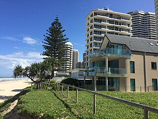
Main Beach is a coastal town and suburb in the City of Gold Coast, Queensland, Australia. In the 2016 census, the suburb of Main Beach had a population of 3,883 people.

Southport is a coastal suburb in the City of Gold Coast in Queensland, Australia. In the 2016 census, Southport had a population of 31,908 people. It contains the Gold Coast central business district.
Harbour Town is a shopping centre concept that incorporates multiple factory outlets in one centre. As of February 2021, there are two locations owned and operated under the Harbour Town brand: Biggera Waters, on Queensland's Gold Coast, and at Adelaide Airport, in South Australia. Harbour Town centres also operated in Perth, Western Australia and Docklands, Victoria before being sold off and rebranded.

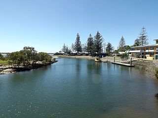
The Gold Coast Seaway or Southport Seaway is the main navigation entrance from the Pacific Ocean into the Gold Coast Broadwater and southern Moreton Bay and is one of Australia's most significant coastal engineering projects. It is located at the northern end of the Southport Spit where the Nerang River enters the Pacific Ocean. The channel was constructed between 1984 and 1986, primarily to facilitate the safe passage of sea-faring vessels. The passage was previously known as the Southport Bar. The mouth of the Nerang River was once located further south in Broadbeach. The main driving force for this movement is the northward drift of sand along the coast.

The Gold Coast Broadwater, also known as Southport Broadwater, Gold Coast Harbour and The Broadwater, is a large shallow estuary of water located in the Gold Coast district of South East Queensland, Australia. The estuary reaches from the locality of Southport in the south, to the southern section of the UNESCO World Heritage Listed Moreton Bay in the north. Separated via the Seaway from the Coral Sea by a thin strip of land called Stradbroke Island, the original body of water was a lagoon created from water deposited from the Nerang River. Part of the Broadwater is contained within the Moreton Bay Marine Park.
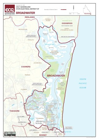
Broadwater is an electoral district of the Legislative Assembly in the Australian state of Queensland. It was created at the 1991 redistribution.

Helensvale is a suburb of the City of Gold Coast in Queensland, Australia. In the 2016 census, Helensvale had a population of 16,862 people.

The Southport Spit is a spit and neighbourhood within the northern end of Main Beach, City of Gold Coast, Queensland, Australia. It is a permanent sand spit that separates the Southport Broadwater from the Pacific Ocean.
Benowa is a suburb in the City of Gold Coast, Queensland, Australia. In the 2016 census, Benowa had a population of 8,741 people.

Coombabah is a suburb in the City of Gold Coast, Queensland, Australia. In the 2016 census, Coombabah had a population of 10,388 people.

Labrador is a coastal suburb in the City of Gold Coast, Queensland, Australia. In the 2016 census, Labrador had a population of 18,261 people.

Parkwood is a suburb in the City of Gold Coast, Queensland, Australia. In the 2016 census, Parkwood had a population of 8,702 people.
The Loders Creek is a stream and tidal creek which flows through the suburbs of the Gold Coast of South East Queensland, Australia. The creek is 8.3 kilometres (5.2 mi) long, and forms part of The Broadwater estuary catchment area.
Runaway Bay is a coastal suburb in the City of Gold Coast, Queensland, Australia. In the 2016 census, Runaway Bay had a population of 9,068 people.

Arundel is a suburb in the City of Gold Coast, Queensland, Australia. In the 2016 census, Arundel had a population of 10,246 people.
The Coombabah Lake Conservation Park is a conservation park that is an Important Wetland in Australia, located in the Gold Coast region of South East Queensland, Australia. Part of the Coomera River catchment, Lake Coombabah is a tidal lake at the mouth of Coombabah Creek. The Coombabah wetlands are significant because they are the most southerly lake and coastal swampland representatives in the bioregion, and because the area provides significant wildlife value and refuge habitat. The conservation area includes tidal marshlands and mangroves along part of the lakes edge. The Melaleuca boardwalk allows viewing of the wildlife. The mangroves are home to frogs, crabs and fish that attract native and migratory birds. There are guided bushwalking and canoeing activities as part of community conservation and environmental workshops to promote local conservation.

Paradise Point is a coastal suburb in the City of Gold Coast, Queensland, Australia. In the 2016 census, Paradise Point had a population of 6,536 people.
Hollywell is a coastal suburb in the City of Gold Coast, Queensland, Australia. In the 2016 census, Hollywell had a population of 2,865 people.


