
The Gold Coast railway line is an interurban railway line operated by Queensland Rail in Queensland, Australia, connecting Brisbane with the Gold Coast.

Southport is a coastal suburb in the City of Gold Coast, Queensland, Australia. In the 2016 census, Southport had a population of 31,908 people. It contains the Gold Coast central business district.
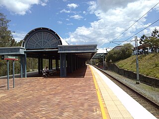
Helensvale railway station is a major public transport interchange in Gold Coast suburb of Helensvale. Helensvale railway station is served by the Queensland Rail Citytrain network Gold Coast line, G:link light rail and Surfside Buslines bus services.

Helensvale is a suburb of the City of Gold Coast in Queensland, Australia. In the 2016 census, Helensvale had a population of 16,862 people.

Coombabah is a suburb in the City of Gold Coast, Queensland, Australia. In the 2016 census, Coombabah had a population of 10,388 people.
Hope Island is a suburb of the City of Gold Coast, Queensland, Australia. The town of Boykambil is within the suburb. The town of Santa Barbara is within the suburb. At the 2016 Census, Hope Island had a population of 11,186. Hope Island is close to both the Gold Coast beaches and Brisbane city.
Oxenford is a suburb in the City of Gold Coast, Queensland, Australia (oFTEN FORGOTTEN N JUST NAMED HELENSVALE,,. In the 2016 census, Oxenford had a population of 11,842 people.

Upper Coomera is a suburb in the City of Gold Coast, Queensland, Australia. Upper Coomera and Coomera have long been the main centre of urban development on the Gold Coast and are considered to be, along with Southport and Robina, one of the Gold Coast's three urban centres. Upper Coomera is a heavily suburbanised suburb consisting of many large residential developments and commercial centres. Despite already being heavily developed and having a large population, Upper Coomera is predicted by both the Queensland Government and Gold Coast City Council to grow and develop at an exponential rate well into the next decade. Upper Coomera is a popular place of residence for dual-city commuters as it is placed roughly halfway between the central commercial districts of Southport and Beenleigh and within reasonable travelling distance to Brisbane CBD.

Runaway Bay is a coastal suburb in the City of Gold Coast, Queensland, Australia. In the 2016 census, Runaway Bay had a population of 9,068 people.

Arundel is a suburb in the City of Gold Coast, Queensland, Australia. In the 2016 census, Arundel had a population of 10,246 people.
Coombabah State High School is a public secondary school located in the northern suburb of Coombabah on the Gold Coast, Queensland, in Australia. It is situated on Pine Ridge Road and is adjacent to the Norco Milk Factory and the Coombabah Sewage Plant.

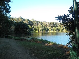
The Coombabah Lake Conservation Park is a conservation park that is an Important Wetland in Australia, located in the Gold Coast region of South East Queensland, Australia. Part of the Coomera River catchment, Lake Coombabah is a tidal lake at the mouth of Coombabah Creek. The Coombabah wetlands are significant because they are the most southerly lake and coastal swampland representatives in the bioregion, and because the area provides significant wildlife value and refuge habitat. The conservation area includes tidal marshlands and mangroves along part of the lakes edge. The Melaleuca boardwalk allows viewing of the wildlife. The mangroves are home to frogs, crabs and fish that attract native and migratory birds. There are guided bushwalking and canoeing activities as part of community conservation and environmental workshops to promote local conservation.
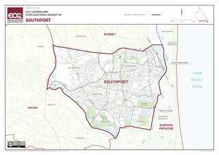
Southport is an electoral district of the Legislative Assembly in the Australian state of Queensland.

The Gold Coast Highway in Queensland, Australia links the coastal suburbs of the Gold Coast such as Miami, Mermaid Beach, Tugun, Bilinga and the Tweed Heads suburb of Tweed Heads West. 39.8 kilometres (24.7 mi) in length, the highway runs from near the Pacific Motorway at Pacific Pines to the Pacific Motorway at Tweed Heads. It passes through the numerous popular tourist areas including Surfers Paradise and Broadbeach, a commercial centre at Southport, residential areas, shopping centres and the Gold Coast (Coolangatta) Airport.
Helensvale High School is a public secondary school located in the suburb of Helensvale on the Gold Coast, Queensland, Australia. It is situated on the corner of Discovery Drive and Helensvale Road. The school first opened in 1990 with Rod Cassidy as the foundation principal. The School motto is One student, one community, many futures.

Cavill Avenue is a street and a pedestrian mall in Surfers Paradise, Gold Coast, Queensland, Australia. It is in the heart of the Surfers Paradise shopping and entertainment district. It was named in honour of the man credited as the founder of Surfers Paradise, James Cavill, known as Jim Cavill.
Hollywell is a coastal suburb in the City of Gold Coast, Queensland, Australia. In the 2016 census, Hollywell had a population of 2,865 people.
Parkwood East light rail station is located off Faldo Court and adjacent to Smith Street Motorway on the eastern portion of Parkwood, a suburb on the Gold Coast. The station is serviced by the Gold Coast G:link light rail system and provides a bus connection. Parkwood East light rail station services the local residential community.

